Waterford, California facts for kids
Quick facts for kids
City of Waterford
|
|
|---|---|
| Motto(s):
Gateway To Recreation
|
|
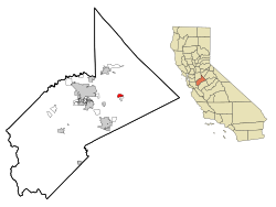
Location in Stanislaus County and the state of California
|
|
| Country | |
| State | |
| County | Stanislaus |
| Established | "Bakersville" in 1857 |
| Incorporated | as "Waterford" on November 7, 1969 |
| Government | |
| • Type | Council-Manager |
| Area | |
| • Total | 2.38 sq mi (6.17 km2) |
| • Land | 2.36 sq mi (6.11 km2) |
| • Water | 0.02 sq mi (0.06 km2) 1.72% |
| Elevation | 171 ft (52 m) |
| Population
(2020)
|
|
| • Total | 9,120 |
| • Density | 3,832/sq mi (1,478.1/km2) |
| Time zone | UTC-8 (PST) |
| • Summer (DST) | UTC-7 (PDT) |
| ZIP code |
95386
|
| Area code(s) | 209 |
| FIPS code | 06-83612 |
| GNIS feature IDs | 1660135, 2412192 |
Waterford is a city in Stanislau County, California. It's the eighth largest city in the county. In 2020, about 9,120 people lived in Waterford. It is part of the larger Modesto area.
Contents
Exploring Waterford's Location
Waterford is located in California at coordinates 37°38′42″N 120°46′3″W / 37.64500°N 120.76750°W. The city covers about 2.4 square miles (6.2 square kilometers). Most of this area is land, with a small part being water.
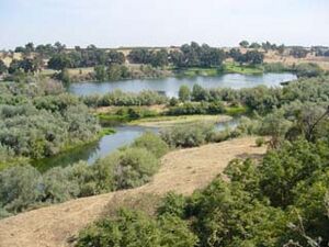
The city was first built near the Tuolumne River. Signs in the city show that Waterford is about 171 feet (52 meters) above sea level.
Waterford's Climate
Waterford has a climate with hot, dry summers and cool, somewhat rainy winters. This is called a Mediterranean climate. Because it's close to the Sierra Nevada foothills, Waterford is usually a little cooler than nearby cities like Modesto.
| Climate data for Waterford, California (1981–2010) | |||||||||||||
|---|---|---|---|---|---|---|---|---|---|---|---|---|---|
| Month | Jan | Feb | Mar | Apr | May | Jun | Jul | Aug | Sep | Oct | Nov | Dec | Year |
| Mean daily maximum °F (°C) | 54.7 (12.6) |
60.9 (16.1) |
65.8 (18.8) |
73.9 (23.3) |
82.4 (28.0) |
89.4 (31.9) |
94.8 (34.9) |
93.4 (34.1) |
88.7 (31.5) |
78.6 (25.9) |
64.8 (18.2) |
54.8 (12.7) |
75.2 (24.0) |
| Mean daily minimum °F (°C) | 37.1 (2.8) |
42.2 (5.7) |
45.2 (7.3) |
48.2 (9.0) |
54.2 (12.3) |
59.1 (15.1) |
62.7 (17.1) |
61.7 (16.5) |
58.4 (14.7) |
51.6 (10.9) |
43.7 (6.5) |
38.7 (3.7) |
50.2 (10.1) |
| Average precipitation inches (mm) | 2.5 (64) |
2.2 (56) |
2.1 (53) |
1.1 (28) |
0.2 (5.1) |
0.0 (0.0) |
0.1 (2.5) |
0.1 (2.5) |
0.3 (7.6) |
0.9 (23) |
2.0 (51) |
1.9 (48) |
13.4 (340.7) |
| Source: NOAA | |||||||||||||
People in Waterford
| Historical population | |||
|---|---|---|---|
| Census | Pop. | %± | |
| 1880 | 63 | — | |
| 1950 | 1,777 | — | |
| 1960 | 1,780 | 0.2% | |
| 1970 | 2,243 | 26.0% | |
| 1980 | 2,683 | 19.6% | |
| 1990 | 4,771 | 77.8% | |
| 2000 | 6,924 | 45.1% | |
| 2010 | 8,456 | 22.1% | |
| 2020 | 9,120 | 7.9% | |
| U.S. Decennial Census | |||
Population in 2010
The 2010 United States Census counted 8,456 people living in Waterford. About 3,570 people per square mile lived in the city. Most residents were White, with a significant number of people identifying as Hispanic or Latino.
There were 2,458 households in Waterford. Over half of these households had children under 18 living in them. The average household had about 3.43 people.
The population included many young people. About 32.9% were under 18 years old. The median age in Waterford was 29.6 years. This means half the people were younger than 29.6 and half were older.
Population in 2000
In the census of 2000, Waterford had 6,923 people. There were 1,991 households. The population density was about 4,338 people per square mile. A large portion of the population, 78.44%, identified as Hispanic or Latino.
Many households had children. About 52.8% of households had children under 18. The average household size was 3.47 people.
The age breakdown showed that 36.4% of people were under 18. The median age was 28 years.
Learning in Waterford
Waterford has its own school system called the Waterford Unified School District.
- Richard Moon Elementary School is for students in kindergarten through third grade. Its mascot is the moon cub, which is a tiger cub.
- Next to Richard Moon Elementary is the Waterford Head Start Program. This program offers preschool options for young children.
- Lucille Whitehead Intermediate School opened in 2008. It shares a campus with Moon School. The school's mascot is the Bobcat.
- Waterford Junior High serves students in 7th and 8th grades. It is the oldest school in the district. Their mascot is the tiger.
- Waterford High School was built in 2001. Around 558 students attend the high school. The WHS mascot is the Wildcat.
Waterford's Past
The area that is now Waterford started to grow in the late 1800s. Back then, it was known as Bakersville. However, mail often got mixed up with another town called Bakersfield, California. So, the smaller town had to change its name.
At that time, there was no bridge over the Tuolumne River. People crossed the river using Roberts Ferry at the "waterfront." Because the area was known for this river crossing, or "ford," the town became known as Waterford.
For many years, a steam train could cross the Tuolumne River on a special bridge. This bridge was taken down in the second half of the 1900s. Today, there are no train tracks running through Waterford, even though some old maps might still show them.
Getting Around Waterford
The city has bus service provided by the Stanislaus Regional Transit Authority.
Waterford has two main highways that cross each other:
- County Route J9 (also called "F Street") goes north to Oakdale and south to Turlock.
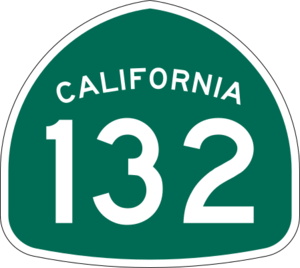
- State Route 132 (also called "Yosemite Blvd.") goes west to Modesto and east towards the Gold Country.
The Hickman-Waterford bridge is also in Waterford. It's the only bridge for about 5 miles (8 kilometers) in either direction that crosses the Tuolumne River after Geer Road.
See also
 In Spanish: Waterford (California) para niños


