Watersmeet, Michigan facts for kids
Quick facts for kids
Watersmeet, Michigan
|
|
|---|---|

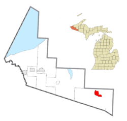
Location within Gogebic County
|
|
| Country | United States |
| State | Michigan |
| County | Gogebic |
| Township | Watersmeet |
| Area | |
| • Total | 9.21 sq mi (23.84 km2) |
| • Land | 9.20 sq mi (23.83 km2) |
| • Water | 0.01 sq mi (0.01 km2) |
| Elevation | 1,598 ft (487 m) |
| Population
(2020)
|
|
| • Total | 408 |
| • Density | 44.35/sq mi (17.12/km2) |
| Time zone | UTC-6 (Central (CST)) |
| • Summer (DST) | UTC-5 (CDT) |
| ZIP code(s) |
49969
|
| Area code(s) | 906 |
| FIPS code | 26-84360 |
| GNIS feature ID | 1622065 |
Watersmeet is a small place in Michigan that doesn't have its own city government. It's known as an unincorporated community. It's also a census-designated place (CDP), which means the government counts the people living there.
In 2010, about 428 people lived in the Watersmeet CDP. The larger area, Watersmeet Township, Michigan, had 1,417 residents. Watersmeet was first planned out in 1884. It started as a stop for the Milwaukee Lake Shore and Western Railroad.
About Watersmeet
Where is Watersmeet?
Watersmeet is located in the northern part of Watersmeet Township, Michigan. This area is in the western part of Michigan's Upper Peninsula. It's a special spot where Duck Creek meets the Middle Branch of the Ontonagon River. This meeting point is called a confluence.
Two major roads, U.S. Route 2 and U.S. Route 45, cross paths at the southern edge of town. U.S. Route 2 goes southeast about 30 miles to Iron River, Michigan. It also goes northwest about 41 miles to Wakefield. U.S. Route 45 heads north about 46 miles to Ontonagon on Lake Superior. It also goes south about 26 miles to Eagle River, Wisconsin. The State Line Trail also runs through the community.
The United States Census Bureau officially defined Watersmeet as a census-designated place in 2010. This means it now has clear boundaries and population numbers. The Watersmeet CDP covers about 9.2 square miles (23.8 square kilometers). Only a tiny part of this area, about 0.06%, is water.
Who Lives in Watersmeet?
This section tells us about the people who live in Watersmeet. It's like taking a snapshot of the community.
| Historical population | |||
|---|---|---|---|
| Census | Pop. | %± | |
| 2020 | 408 | — | |
| U.S. Decennial Census | |||
The 2020 census counted 408 people living in the Watersmeet CDP. This number helps us understand how the population changes over time.
Other Cool Stuff
 In Spanish: Watersmeet (Míchigan) para niños
 | James Van Der Zee |
 | Alma Thomas |
 | Ellis Wilson |
 | Margaret Taylor-Burroughs |


