Wax Lake facts for kids
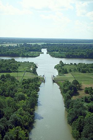
Wax Lake was once a lake in St. Mary Parish, Louisiana. It was changed into a special channel called the Wax Lake outlet. This channel helps move water from the Atchafalaya River directly to the Gulf of Mexico.
Contents
Why the Wax Lake Outlet Was Built
The Wax Lake Outlet, along with other channels like the Charenton Drainage and Navigation Canal, was created for a very important reason. Its main purpose was to help prevent floods in the lower Atchafalaya Basin and in the city of Morgan City. These channels were designed to safely move extra water away, protecting homes and businesses.
Building the Wax Lake Outlet
The Wax Lake outlet is a man-made channel. It was built by the United States Army Corps of Engineers starting in 1942. The goal was to send about 30% of the water from the Atchafalaya River straight to the Gulf of Mexico. This helps lower water levels during floods, especially around Morgan City, Louisiana. This outlet can handle a huge amount of water, up to 440,000 cubic feet per second, during big floods.
How the Outlet Was Constructed
Building the Wax Lake Outlet was a bit unusual. They started by building the bridges first! This included bridges for roads over the flood basin and a special swing bridge for the Southern Pacific Railroad in Baldwin. They also built a large K-truss bridge in Calumet. In total, six bridges were built on dry land between Baldwin and Calumet.
After the bridges were started, the digging began. Workers used special machines to dredge (dig out) the new channel. The Wax Lake Outlet is about 15 miles long and starts at Six Mile Lake (also called Yellow Bayou). Another channel, the Charenton Drainage and Navigation Canal, started digging from Bayou Teche in Baldwin. Both digging projects began in 1941 and were finished by 1942.
Understanding the Wax Lake Delta
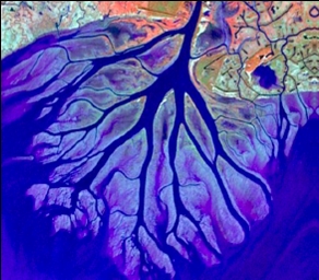
The Wax Lake Delta is a special landform in Louisiana. It's a river delta, which means it's an area of land that forms when a river drops sediment (like mud and sand) as it flows into a larger body of water. This delta grew quickly after the Wax Lake outlet canal was built in 1942. It's located about 20 miles (32 km) southwest of Morgan City, right next to the Atchafalaya delta.
How the Delta Grows
The Wax Lake Delta gets a massive amount of sediment every year – about 34 million tons! Because of this, the original Wax Lake completely filled up with sediment between 1941 and 2005. The delta then grew outwards into the sea by about 8 kilometers (5 miles).
The delta's channels, which are like small rivers, form as sediment builds up. The first branch to the west is called Campground Pass. Further south, there are three main branches: East Pass, Greg Pass, and Main Pass. As water flows, it erodes (wears away) the middle of a channel and deposits the sediment further downstream. This often happens during times of high water flow. This process creates new paths for the water and causes the river to split, forming a pattern that looks a bit like the branches of a tree.
Studying the Delta
Scientists love to study the Wax Lake Delta. This is because it was created entirely during a time when people could watch it form. Also, humans didn't change it much after the canal was built. This makes it a perfect natural laboratory to understand how deltas form.
After Hurricane Katrina, the Wax Lake Delta also became a model for how to regrow deltas in the Mississippi River Delta region. Restoring these natural delta areas helps create new habitats for wildlife and can protect against strong storm surges from storms.
 | Jackie Robinson |
 | Jack Johnson |
 | Althea Gibson |
 | Arthur Ashe |
 | Muhammad Ali |


