Waynesboro, Mississippi facts for kids
Quick facts for kids
Waynesboro, Mississippi
|
|||
|---|---|---|---|

Wayne County Courthouse in Waynesboro
|
|||
|
|||

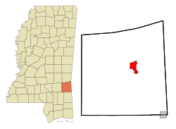
Location of Waynesboro, Mississippi
|
|||
| Country | United States | ||
| State | Mississippi | ||
| County | Wayne | ||
| Area | |||
| • Total | 12.70 sq mi (32.90 km2) | ||
| • Land | 12.69 sq mi (32.87 km2) | ||
| • Water | 0.008 sq mi (0.02 km2) | ||
| Elevation | 190 ft (58 m) | ||
| Population
(2020)
|
|||
| • Total | 4,567 | ||
| • Density | 359.80/sq mi (138.92/km2) | ||
| Time zone | UTC-6 (Central (CST)) | ||
| • Summer (DST) | UTC-5 (CDT) | ||
| ZIP code |
39367
|
||
| Area code(s) | 601 | ||
| FIPS code | 28-78360 | ||
| GNIS feature ID | 0690942 | ||
| Website | http://waynesboroms.us/ | ||
Waynesboro is a city located in Wayne County, Mississippi, in the United States. It is the main town and the county seat of Wayne County. This means it's where the county government offices are located. In 2020, about 4,567 people lived there.
Contents
History of Waynesboro
Early Beginnings
Waynesboro started to grow in 1854. This was when the Mobile and Ohio Railroad built tracks through Wayne County. A train station called Waynesboro Station was built about five miles north of another town called Winchester.
The railroad company then began to sell land around this new station. This helped the future town of Waynesboro to develop. In 1867, Waynesboro became the new county seat, taking over from Winchester.
Growth and Development
A big change happened in Waynesboro during the 1940s. Oil was discovered in Wayne County! This discovery led to a huge boost in the local economy and population.
Many people moved to Waynesboro for work. The city's population more than doubled in just ten years. It grew from 1,445 residents in 1940 to 3,442 residents by 1950.
Waynesboro also has its own radio stations. WABO (AM) started broadcasting in 1954. Later, WABO-FM began its broadcasts in 1973.
Geography of Waynesboro
Waynesboro is located in Mississippi, near the Chickasawhay River. The city covers a total area of about 6.7 square miles (17.4 square kilometers). Most of this area is land, with only a very small part being water.
People of Waynesboro
Population Changes Over Time
The population of Waynesboro has changed quite a bit over the years. Here's how it has grown and changed since 1880:
| Historical population | |||
|---|---|---|---|
| Census | Pop. | %± | |
| 1880 | 156 | — | |
| 1890 | 458 | 193.6% | |
| 1900 | 436 | −4.8% | |
| 1910 | 652 | 49.5% | |
| 1920 | 689 | 5.7% | |
| 1930 | 1,120 | 62.6% | |
| 1940 | 1,445 | 29.0% | |
| 1950 | 3,442 | 138.2% | |
| 1960 | 3,892 | 13.1% | |
| 1970 | 4,368 | 12.2% | |
| 1980 | 5,349 | 22.5% | |
| 1990 | 5,143 | −3.9% | |
| 2000 | 5,197 | 1.0% | |
| 2010 | 5,043 | −3.0% | |
| 2020 | 4,567 | −9.4% | |
| U.S. Decennial Census | |||
Waynesboro in 2020
In 2020, the 2020 United States Census counted 4,567 people living in Waynesboro. There were 1,786 households and 1,219 families in the city.
The people living in Waynesboro come from different backgrounds. Here's a look at the racial makeup of the city:
| Race | Number of People | Percentage |
|---|---|---|
| White | 1,364 | 29.87% |
| Black or African American | 2,888 | 63.24% |
| Native American | 3 | 0.07% |
| Asian | 18 | 0.39% |
| Pacific Islander | 1 | 0.02% |
| Other/Mixed | 85 | 1.86% |
| Hispanic or Latino | 208 | 4.55% |
Waynesboro in 2010
Back in 2010, the city had 5,043 people. About 61.9% were African American, and 35.2% were White. A smaller number of people were Native American, Asian, or Pacific Islander. About 1.9% of the population was Hispanic or Latino.
Education in Waynesboro
Students in Waynesboro attend schools run by the Wayne County School District. For high school, students can go to Wayne County High School, which is a public school. There is also a private school option called Wayne Academy. For college, the county is part of the zone for Jones College.
Notable People from Waynesboro
Many interesting people have come from Waynesboro:
- Three Major League Baseball players were born here: Claude Passeau (born 1909), Paul Busby (born 1918), and Jeff Branson (born 1967).
- Jalin Wood, a beauty queen, was born in Waynesboro. She won Miss Mississippi in 2004 and competed in the Miss America and Miss USA pageants.
- Spencer Johnson played professional football as a defensive tackle for the Minnesota Vikings and Buffalo Bills.
- James Marion West, Sr., a famous oilman, cattle rancher, and lumberman, was born in Waynesboro in 1871.
- Benito Jones is a professional football player for the Detroit Lions.
See also
 In Spanish: Waynesboro (Misisipi) para niños
 | May Edward Chinn |
 | Rebecca Cole |
 | Alexa Canady |
 | Dorothy Lavinia Brown |


