Wenaha River facts for kids
Quick facts for kids Wenaha River |
|
|---|---|

Wenaha River
|
|
|
Location of the mouth of the Wenaha River in Oregon
|
|
| Country | United States |
| State | Oregon |
| County | Wallowa |
| Physical characteristics | |
| Main source | confluence of the river's north and south forks Wenaha–Tucannon Wilderness, Blue Mountains 2,807 ft (856 m) 45°57′03″N 117°47′39″W / 45.95083°N 117.79417°W |
| River mouth | Grande Ronde River Troy 1,601 ft (488 m) 45°56′44″N 117°27′07″W / 45.94556°N 117.45194°W |
| Length | 21.6 mi (34.8 km) |
| Basin features | |
| Basin size | 296 sq mi (770 km2) |
| Type: | Wild, Scenic, Recreational |
| Designated: | October 28, 1988 |
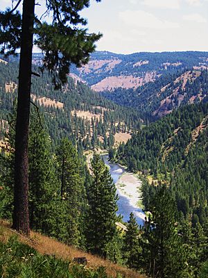
The Wenaha River is a beautiful river in Oregon, a state in the United States. It flows for about 22 miles (35 km) (35 km). This river is special because it's part of the National Wild and Scenic Rivers System. This means it's protected for its natural beauty and importance.
The Wenaha River starts in the Blue Mountains. It flows through a wild area called the Wenaha–Tucannon Wilderness. The river ends when it joins a larger river, the Grande Ronde River, near the small town of Troy. The entire river is located within Wallowa County.
Contents
The River's Journey: Where the Wenaha Flows
The Wenaha River begins when two smaller rivers meet. These are the North Fork Wenaha River and the South Fork Wenaha River. The North Fork starts in Washington state at about 5,700 feet (1,700 m) high. The South Fork also starts at about 5,700 feet (1,700 m) high, but in Oregon.
These two forks join together at about 2,800 feet (850 m) elevation. This meeting point is inside the Wenaha–Tucannon Wilderness. This wilderness area is part of the Umatilla National Forest. From there, the Wenaha River flows mainly east through the Blue Mountains in northeastern Oregon.
Smaller Streams Joining the River
As the Wenaha River flows, many smaller streams, called tributaries, join it. These streams add more water to the river. Some of these tributaries include Beaver Creek, Slick Ear Creek, and Rock Creek. Others are Big Hole Canyon, Butte Creek, Swamp Creek, Weller Creek, Cross Canyon, Fairview Creek, Burnt Canyon, and Crooked Creek.
After Crooked Creek joins, the Wenaha River leaves the wilderness area. It then flows southeast and exits the national forest. Finally, it turns east again and flows into the Grande Ronde River at Troy. This meeting point is about 45 miles (72 km) (72 km) from where the Grande Ronde River joins the Snake River.
Exploring the Wenaha River: Fun Things to Do
The Wenaha River area is a great place for outdoor adventures. There's a long path called the Wenaha River Trail.
Hiking and Backpacking on the Trail
The Wenaha River Trail is about 31 miles (50 km) (50 km) long. It follows the Wenaha River and its South Fork. You can hike or backpack on this trail, depending on the weather. The United States Forest Service says this trail is "more difficult."
The trail starts at about 1,600 feet (490 m) (488 m) elevation near Troy. It goes up to about 4,700 feet (1,400 m) (1433 m) at a place called Timothy Springs. This area is close to the border of Union County.
Fishing in the Wenaha River
Fishing is a popular activity along the Wenaha River. The river is quiet and secluded, making it a peaceful spot. You can find many wild rainbow trout here. These fish usually range from 6 to 18 inches (15 to 46 cm) (15 to 46 cm) long.
Sometimes, you might also see steelhead in the river. Steelhead are a type of rainbow trout that live in the ocean and swim up rivers to lay their eggs. Fishing for steelhead here is limited to protect them.
Another type of fish in the river is the bull trout. These fish are protected, so if you catch one, you must release it back into the water. This is called "catch-and-release" fishing. It helps keep the bull trout population healthy.
 | Anna J. Cooper |
 | Mary McLeod Bethune |
 | Lillie Mae Bradford |


