West Burlington, Iowa facts for kids
Quick facts for kids
West Burlington, Iowa
|
|
|---|---|

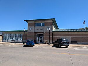
The West Burlington city hall
|
|
| Motto(s):
"A Vibrant, Progressive Community"
|
|

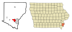
Location of West Burlington, Iowa
|
|
| Country | |
| State | |
| County | Des Moines |
| Area | |
| • Total | 4.84 sq mi (12.53 km2) |
| • Land | 4.84 sq mi (12.53 km2) |
| • Water | 0.00 sq mi (0.00 km2) |
| Elevation | 696 ft (212 m) |
| Population
(2020)
|
|
| • Total | 3,197 |
| • Density | 660.95/sq mi (255.18/km2) |
| Time zone | UTC-6 (Central (CST)) |
| • Summer (DST) | UTC-5 (CDT) |
| ZIP code |
52655
|
| Area code(s) | 319 |
| FIPS code | 19-83685 |
| GNIS feature ID | 0462827 |
| Website | The City of West Burlington, Iowa |
West Burlington is a city in Des Moines County, Iowa, United States. It is very close to Burlington, a city on the Mississippi River. In 2020, about 3,197 people lived there. West Burlington is part of the larger Burlington, Iowa–IL area.
Contents
Exploring West Burlington's Location
West Burlington is located at specific coordinates: 40.820318 degrees North and 91.164492 degrees West. This helps us find it on a map.
The United States Census Bureau says the city covers an area of about 4.95 square miles (12.82 square kilometers). All of this area is land, with no large bodies of water inside the city limits.
West Burlington's Population Over Time
| Historical populations | ||
|---|---|---|
| Year | Pop. | ±% |
| 1890 | 836 | — |
| 1900 | 1,044 | +24.9% |
| 1910 | 1,206 | +15.5% |
| 1920 | 1,212 | +0.5% |
| 1930 | 1,333 | +10.0% |
| 1940 | 1,323 | −0.8% |
| 1950 | 1,614 | +22.0% |
| 1960 | 2,560 | +58.6% |
| 1970 | 3,139 | +22.6% |
| 1980 | 3,371 | +7.4% |
| 1990 | 3,083 | −8.5% |
| 2000 | 3,161 | +2.5% |
| 2010 | 2,968 | −6.1% |
| 2019 | 2,890 | −2.6% |
| 2020 | 3,197 | +10.6% |
| Source: and Iowa Data Center Source: |
||
Population in 2020
According to the census from 2020, West Burlington had 3,197 residents. There were 1,395 households in the city. The city had about 664.9 people living per square mile.
Most people in West Burlington were White (82.6%). Other groups included Black or African American (5.2%), Asian (3.9%), and Native American (0.1%). About 4.8% of the population was Hispanic or Latino.
The average age of people in the city was 42.5 years. About 24.2% of the residents were under 20 years old.
Population in 2010
In the 2010 census, West Burlington had 2,968 people. The population density was about 599.6 people per square mile.
The racial makeup was mostly White (90.7%). Other groups included African American (4.1%) and Asian (1.8%). About 3.9% of the population was Hispanic or Latino.
The average age in 2010 was 44.4 years. About 20.2% of residents were under 18 years old.
Schools in West Burlington
Most students in West Burlington attend schools in the West Burlington Independent School District. Some areas on the western side of the city are part of the Burlington Community School District.
Getting Around: Transportation
West Burlington is an important place for Burlington Trailways, which is a company that operates buses between cities. Because of this, many intercity buses come and go from the bus station in West Burlington.
See also
 In Spanish: West Burlington (Iowa) para niños
 | Kyle Baker |
 | Joseph Yoakum |
 | Laura Wheeler Waring |
 | Henry Ossawa Tanner |


