West Carson, California facts for kids
Quick facts for kids
West Carson, California
|
|
|---|---|

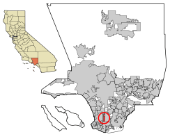
Location of West Carson in Los Angeles County.
|
|
| Country | |
| State | |
| County | |
| Area | |
| • Total | 2.279 sq mi (5.902 km2) |
| • Land | 2.266 sq mi (5.869 km2) |
| • Water | 0.013 sq mi (0.033 km2) 0.56% |
| Elevation | 43 ft (13 m) |
| Population
(2020)
|
|
| • Total | 22,870 |
| • Density | 10,035/sq mi (3,875.0/km2) |
| Time zone | UTC-8 (PST) |
| • Summer (DST) | UTC-7 (PDT) |
| ZIP code |
90502
90710 (Harbor City P.O.) |
| FIPS code | 06-84144 |
| GNIS feature ID | 1867069 |
West Carson is a community in Los Angeles County, California. It's not an official city, but an "unincorporated community." This means it's a populated area that is not part of any city. Instead, it's directly governed by the county. West Carson is located in the South Bay area of Los Angeles County. In 2020, about 22,870 people lived there. The United States Census Bureau counts West Carson as a special area for statistics, called a "census-designated place" (CDP).
Exploring West Carson's Location
West Carson is surrounded by other places in Los Angeles County. To its east, you'll find the city of Carson. This border runs along the Harbor Freeway (also known as Interstate 110).
Borders and Nearby Areas
The city of Los Angeles surrounds West Carson on its other three sides.
- To the north, Del Amo Boulevard forms the boundary with the Harbor Gateway neighborhood of Los Angeles.
- To the south, Lomita Boulevard is the border with the Harbor City neighborhood.
- The western border, along Normandie Avenue, is also shared with parts of Los Angeles.
ZIP Codes and Size
Most of West Carson uses the ZIP Code 90502. The United States Postal Service often links this ZIP Code to Torrance, a city located just west of West Carson. A smaller southern part of West Carson shares the 90710 ZIP Code with the Harbor City neighborhood.
The United States Census Bureau reports that West Carson covers about 2.3 square miles (about 5.9 square kilometers). Almost all of this area is land.
People of West Carson
The number of people living in West Carson has grown over the years.
| Historical population | |||
|---|---|---|---|
| Census | Pop. | %± | |
| 1970 | 15,918 | — | |
| 1980 | 17,997 | 13.1% | |
| 1990 | 20,143 | 11.9% | |
| 2000 | 21,138 | 4.9% | |
| 2010 | 21,699 | 2.7% | |
| 2020 | 22,870 | 5.4% | |
| U.S. Decennial Census | |||
Population in 2010
In 2010, West Carson had a population of 21,699 people. This means there were about 9,522 people living in every square mile.
Diversity of Residents
The community is home to people from many different backgrounds:
- About 35.2% of residents were White.
- Around 10.7% were African American.
- About 0.9% were Native American.
- Around 31.0% were Asian.
- About 1.4% were Pacific Islander.
- Around 15.7% were from other racial groups.
- About 5.1% identified as being from two or more races.
- Overall, about 32.7% of the people were of Hispanic or Latino background.
Most people (94.4%) lived in regular homes. A small number lived in group housing or institutions.
Households and Families
There were 7,166 households in West Carson.
- About 31.2% of these households had children under 18.
- More than half (50.7%) were married couples.
- About 13.6% were led by a female without a husband present.
- About 6.3% were led by a male without a wife present.
- The average household had about 2.86 people.
- There were 5,062 families, with an average of 3.40 people per family.
Age Groups
The ages of people in West Carson varied:
- About 18.7% were under 18 years old.
- About 8.4% were between 18 and 24.
- About 26.8% were between 25 and 44.
- About 28.2% were between 45 and 64.
- About 18.0% were 65 or older.
The average age in West Carson was 42.1 years.
Housing and Income
There were 7,426 housing units. Most homes (76.2%) were owned by the people living in them, while 23.8% were rented. In 2010, the typical household income in West Carson was $62,100. About 8.6% of the population lived below the federal poverty line.
Population in 2000
In 2000, West Carson had 21,138 people living in 7,156 households. The population density was about 9,355 people per square mile.
Racial Makeup in 2000
The racial makeup in 2000 was:
- 41.99% White
- 11.75% African American
- 0.66% Native American
- 25.07% Asian
- 1.20% Pacific Islander
- 13.94% from other races
- 5.39% from two or more races
About 29.44% of the population was Hispanic or Latino.
Household Details in 2000
- About 29.6% of households had children under 18.
- 52.6% were married couples.
- The average household size was 2.85 people, and the average family size was 3.41 people.
Age and Income in 2000
The average age was 38 years. The median household income was $49,118. About 9.5% of the population lived below the poverty line.
Schools in West Carson
Students in West Carson attend schools that are part of the Los Angeles Unified School District. Two elementary schools are located right in West Carson:
- Meyler Street Elementary School
- Van Deene Elementary School
See also
 In Spanish: West Carson para niños
 | Tommie Smith |
 | Simone Manuel |
 | Shani Davis |
 | Simone Biles |
 | Alice Coachman |


