West Fork Millicoma River facts for kids
Quick facts for kids West Fork Millicoma River |
|
|---|---|

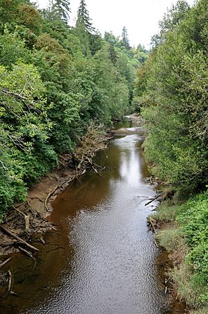
View from the Oregon Route 241 bridge at Allegany
|
|
|
Location of the mouth of the West Fork Millicoma River in Oregon
|
|
| Country | United States |
| State | Oregon |
| County | Coos |
| Physical characteristics | |
| Main source | near Elk Peak northeastern Coos County, Southern Oregon Coast Range 1,519 ft (463 m) 43°33′08″N 123°53′17″W / 43.55222°N 123.88806°W |
| River mouth | Millicoma River Allegany 23 ft (7.0 m) 43°25′27″N 124°01′48″W / 43.42417°N 124.03000°W |
| Length | 34 mi (55 km) |
The West Fork Millicoma River is a river in Oregon, a state in the United States. It's about 34 miles (55 km) long. This river is a tributary, which means it's a smaller river that flows into a larger one. The West Fork Millicoma flows into the Millicoma River.
The river starts in the northeastern part of Coos County. It flows through the Elliott State Forest in the Southern Oregon Coast Range. Finally, it reaches a community called Allegany. There, it meets the East Fork Millicoma River to form the main Millicoma River. The Millicoma River then joins the South Fork Coos River to create the Coos River. The Coos River is short, only about 5 miles (8 km) long, and it empties into Coos Bay, which connects to the Pacific Ocean.
Contents
River's Journey: Where it Flows
The West Fork Millicoma River begins its journey northeast of a place called Elk Peak. It first flows north, running alongside Umpcoos Ridge. Then, it turns west. Along its path, many smaller streams, called tributaries, join it. Some of these include Cougar Creek, Kelly Creek, and Panther Creek.
As the river continues, it turns south. About 24.5 miles (39.4 km) from where it ends, Joes Creek adds its waters. A bit further downstream, Buck Creek joins in. Another stream, Trout Creek, flows into the river about 19 miles (31 km) from its end.
Waterfalls and Turns
About 17 miles (27 km) from its mouth, the river turns west. A mile later, it drops over a waterfall called Stulls Falls and then turns south again. Near 14 miles (23 km) from its end, the river turns west once more and goes over Henrys Falls. After this, it winds generally south-southwest.
Before the river passes over Pidgeon Falls, Schumacher Creek flows into it. Then, Totten and Daggett creeks join the river about 7 miles (11 km) from its mouth. The river also flows past a special station called a stream gauge. This station helps scientists measure how much water is in the river. The river then flows around a bend called Devils Elbow. Finally, Rainy Creek joins from the left before the West Fork Millicoma River meets the East Fork Millicoma River in Allegany. A road called West Fork Millicoma Road follows the river for much of its length.
Fun on the River: Recreation
The West Fork Millicoma River is a great place for fishing. You can find steelhead (which are a type of rainbow trout) and coastal cutthroat trout here. The best trout fishing is usually closer to where the river starts.
Fishing and the Hatchery
There's a special place called a hatchery about 9 miles (14 km) upstream from Allegany. A hatchery is like a fish farm where young steelhead are raised. These young fish are then released into the lower part of the river to help keep the fish population healthy. It can be tricky to fish downstream from the hatchery because it's hard to reach the riverbanks. Also, the rapids can make boating dangerous. However, the hatchery site itself has places where you can easily fish from the bank. The hatchery also has a visitor center where you can learn more about the river and its fish.
Whitewater Adventures
If you like adventure, some people enjoy whitewater activities on a part of the river. This section is about 6 to 9 miles (10 to 14 km) long and starts upstream of Henry's Falls. Whitewater means the river has fast-moving water and rapids. Obstacles like Henry's Falls, which is a 10-foot (3.0 m) drop, are usually checked out carefully before people try to go over them. Sometimes, people even carry their boats around these obstacles, which is called portaging.
 | Emma Amos |
 | Edward Mitchell Bannister |
 | Larry D. Alexander |
 | Ernie Barnes |


