West Point, Utah facts for kids
Quick facts for kids
West Point, Utah
|
|
|---|---|

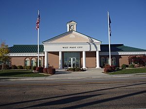
West Point City Municipal Center
|
|

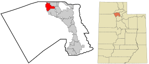
Location in Davis County and the state of Utah
|
|
| Country | United States |
| State | Utah |
| County | Davis |
| Settled | 1867 |
| Incorporated | 1935 |
| Area | |
| • Total | 7.14 sq mi (18.50 km2) |
| • Land | 7.11 sq mi (18.43 km2) |
| • Water | 0.03 sq mi (0.07 km2) |
| Elevation | 4,288 ft (1,307 m) |
| Population
(2010)
|
|
| • Total | 9,511 |
| • Density | 1,540.20/sq mi (594.64/km2) |
| Time zone | UTC-7 (Mountain (MST)) |
| • Summer (DST) | UTC-6 (MDT) |
| ZIP code |
84015
|
| Area code(s) | 385, 801 |
| FIPS code | 49-83390 |
| GNIS feature ID | 2412226 |
West Point is a city located in Davis County, Utah, in the United States. It is part of the larger Ogden-Clearfield Metropolitan Area. In 2010, about 9,511 people lived there. By 2019, the population was estimated to be around 10,957. The city has been growing quickly, mostly with new homes for families.
West Point was first settled in March 1867. Its name comes from the famous United States Military Academy at West Point. Before it became an official city, people sometimes called the area "South Hooper" or "Muskrat Springs."
Where is West Point?
West Point is located right next to the eastern shore of the Great Salt Lake. There are many wetlands along its western side. These wetlands are very important places for birds that migrate, meaning they travel long distances each year.
The cities of Clinton and Hooper are to the north of West Point. Clearfield is to the east, and Syracuse is to the south.
The city covers about 7.14 square miles (18.50 square kilometers). Most of this area is land, with a small part being water. West Point plans to add a few more square miles to its territory in the future. This new area is in the northwest part of Davis County and is not currently part of any city.
How Many People Live Here?
| Historical population | |||
|---|---|---|---|
| Census | Pop. | %± | |
| 1900 | 227 | — | |
| 1910 | 337 | 48.5% | |
| 1920 | 396 | 17.5% | |
| 1930 | 572 | 44.4% | |
| 1940 | 586 | 2.4% | |
| 1950 | 433 | −26.1% | |
| 1960 | 599 | 38.3% | |
| 1970 | 1,020 | 70.3% | |
| 1980 | 2,170 | 112.7% | |
| 1990 | 4,258 | 96.2% | |
| 2000 | 6,033 | 41.7% | |
| 2010 | 9,511 | 57.6% | |
| 2019 (est.) | 10,957 | 15.2% | |
| U.S. Decennial Census | |||
In 2000, there were 6,033 people living in West Point. Most of the people were White (about 94.73%). There were also smaller groups of African American, Native American, and Asian people. About 4.03% of the population was Hispanic or Latino.
Many families live in West Point. In 2000, about 58.3% of households had children under 18 living with them. Most households (82.2%) were married couples living together. The average household had about 3.67 people.
The population in West Point is quite young. About 38.3% of the people were under 18 years old. The average age of people in the city was 27 years.
Schools in West Point
West Point has several schools for students of different ages:
- [West Point Elementary]
- [Lakeside Elementary]
- [Island View Elementary]
- [West Point Junior High]
See also
 In Spanish: West Point (Utah) para niños

