
Gyalshing district facts for kids
Quick facts for kids
Gyalshing district
|
|
|---|---|
|
District of Sikkim
|
|
| Geyzing district | |

Rabdentse Palace in Rabdentse in Gyalshing district, Sikkim
|
|
.svg)
Location in Sikkim
|
|
| Country | |
| State | |
| Headquarters | Gyalshing or Geyzing |
| Population
(2011)
|
|
| • Total | 71,675 |
| Time zone | UTC+05:30 (IST) |
| ISO 3166 code | IN-SK |
| Vehicle registration | SK-02, SK-06 |
Gyalshing District, also known as Geyzing District, is a district in the Indian state of Sikkim. Its main town and administrative center is Geyzing, which is also called Gyalshing. This district is very popular with people who love to hike because of its high mountains. Other important towns here are Pelling and Yuksom. Local people sometimes call it Pallo-Sikkim or Sano-Sikkim.
Contents
History of Gyalshing District
Gyalshing district has a rich history. It was once home to Yuksom, the very first capital of the ancient state of Sikkim. Yuksom served as the capital for almost 50 years, starting in 1642. Later, the capital was moved to Rabdentse.
For about 30 years in the 18th and 19th centuries, the district was taken over by the Nepalese. However, after a war between the British and the Nepalese (called the Anglo-Nepalese War) from 1814 to 1816, the district was given back to Sikkim.
Geography and Natural Wonders
Gyalshing district covers an area of about 1,166 square kilometers (450 square miles). It has many interesting places to visit.
Famous Lakes and Monasteries
One famous spot is the Khecheopalri Lake. A local story says that not a single leaf is allowed to fall on the lake's surface. Another important place is the Dubdi Monastery, which was the first monastery built in Sikkim.
National Protected Areas
Part of the Khangchendzonga National Park is located within Gyalshing district. This park is a special area that protects nature and wildlife.
Economy and Livelihoods
The main way people earn a living in Gyalshing district is through farming. Even though much of the land is steep and rocky, making it hard to grow crops, agriculture is still very important here.
Transportation and Roads
Getting around Gyalshing district can be tricky. The roads are often in poor condition because of frequent landslides, which are common in hilly areas.
People and Culture
According to the 2011 census, Gyalshing district had a population of 136,435 people. This number is similar to the population of a small country like Grenada. The district has about 117 people living per square kilometer. Between 2001 and 2011, the population grew by about 10.58%.
Population Details
The district has 941 females for every 1000 males. About 78.69% of the people can read and write. After the district was divided, its population became 71,675. A small part of the population (about 4.73%) belongs to groups called Scheduled Castes, and a larger part (about 44.43%) belongs to Scheduled Tribes. These are special groups of people recognized by the government.
Ethnic Groups and Languages
Most people in Gyalshing district are of Limbu descent. Other groups living here include the Lepcha and Bhutia communities. Nepali is the most common language spoken in the district.
Religions in Gyalshing District
| Religion in Gyalshing district (2011) | ||||
|---|---|---|---|---|
| Hinduism | 60.07% | |||
| Buddhism | 25.99% | |||
| Other (mainly Kirat Mundhum) | 6.73% | |||
| Christianity | 6.06% | |||
| Islam | 0.94% | |||
| Other or not stated | 0.21% | |||

Hinduism is the religion followed by most people in the district. Buddhism is also followed by many people. The Kirateshwar Mahadev Temple, an important Hindu pilgrimage site in Sikkim, is located in Legship within the district.
Languages Spoken
In 2011, the most common language spoken in the district was Nepali (51.85%). Other languages spoken include Limbu (22.61%), Lepcha (8.68%), Bhotia (7.05%), Sherpa (2.69%), Rai (1.55%), and Hindi (1.48%).
Flora and Fauna of Gyalshing District

Gyalshing district is home to a wide variety of plants and animals. Many of these are used by the local communities. Since most of the district is hilly, it has a mild, temperate climate. In areas above 3,800 meters (12,000 feet), you can find beautiful forests filled with rhododendron flowers.
In 1977, the Khangchendzonga National Park was established in the district. This park covers an area of about 1,784 square kilometers (689 square miles) and is shared with North Sikkim district. It helps protect the amazing wildlife and plants of the region.
Administrative Divisions


Scenes from the district
Gyalshing district is split into two main administrative areas called sub-divisions:
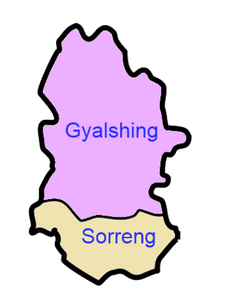
| Name | Headquarters | Number of villages | Location |
| Gyalshing | Gyalshing |
 |
|
| Soreng | Soreng |
 |
See also
 In Spanish: Distrito de Sikkim occidental para niños
