West St. Paul, Minnesota facts for kids
Quick facts for kids
West St. Paul
|
|
|---|---|
| City of West St. Paul | |
 |
|
| Nickname(s):
W.S.P.
|
|
| Motto(s):
"We're Close To It All"
|
|

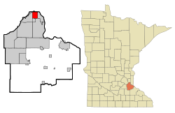
Location of the city of West St. Paul
within Dakota County, Minnesota |
|
| Country | United States |
| State | Minnesota |
| County | Dakota |
| Founded | 1858 |
| Incorporated | February 23, 1889 |
| Area | |
| • Total | 5.01 sq mi (12.98 km2) |
| • Land | 4.91 sq mi (12.71 km2) |
| • Water | 0.10 sq mi (0.27 km2) |
| Elevation | 1,027 ft (313 m) |
| Population
(2020)
|
|
| • Total | 20,615 |
| • Estimate
(2022)
|
21,794 |
| • Density | 4,200.29/sq mi (1,621.70/km2) |
| Time zone | UTC-6 (Central (CST)) |
| • Summer (DST) | UTC-5 (CDT) |
| ZIP code |
55118
|
| Area code(s) | 651 |
| FIPS code | 27-69700 |
| GNIS feature ID | 654003 |
| Sales tax | 8.625% |
West St. Paul is a city located in Dakota County, Minnesota, in the United States. In 2020, about 20,615 people lived there. It's right next to Saint Paul on its south side and South St. Paul on its west side.
Contents
History of West St. Paul
The city's name can be a bit confusing! It's called West St. Paul because it sits on the west side of the Mississippi River. This river mainly flows from north to south.
Long ago, in the late 1800s, there was another city also called West St. Paul. That city was located in what is now part of Saint Paul. Saint Paul took over that area for two main reasons. First, it helped with law enforcement. Criminals could not just cross the river to escape police. Second, it removed tolls on a bridge, which helped the area grow.
The current city of West St. Paul was formed in 1889. It separated from the western part of South St. Paul. It is located just south of the city of Saint Paul. In 2020, the population was 20,615, which was 1,075 more people than in 2010. West St. Paul is also known for its 2.5-mile long shopping area along Robert Street.
Geography and Roads
West St. Paul covers about 5.01 square miles (12.98 square kilometers). Most of this area is land, with a small part being water.
Several important roads run through West St. Paul:
- U.S. Highway 52, also known as the Lafayette Freeway.
- Robert Street.
- Minnesota Highway 62.
Interstate Highway 494 is just south of the city. Minnesota Highway 3 (also called Route 952) goes through the middle of the city and into downtown Saint Paul. Robert Street was named after Captain Louis Robert, who was a boat captain on the Mississippi River and an early settler in Saint Paul.
Population and People
| Historical population | |||
|---|---|---|---|
| Census | Pop. | %± | |
| 1890 | 1,596 | — | |
| 1900 | 1,830 | 14.7% | |
| 1910 | 2,660 | 45.4% | |
| 1920 | 2,962 | 11.4% | |
| 1930 | 4,463 | 50.7% | |
| 1940 | 5,733 | 28.5% | |
| 1950 | 7,955 | 38.8% | |
| 1960 | 13,101 | 64.7% | |
| 1970 | 18,802 | 43.5% | |
| 1980 | 18,527 | −1.5% | |
| 1990 | 19,248 | 3.9% | |
| 2000 | 19,405 | 0.8% | |
| 2010 | 19,540 | 0.7% | |
| 2020 | 20,615 | 5.5% | |
| 2022 (est.) | 21,794 | 11.5% | |
| U.S. Decennial Census 2020 Census |
|||
How Many People Live Here?
In 2010, there were 19,540 people living in West St. Paul. These people lived in 8,529 households, with 4,751 being families. The population density was about 3,980 people per square mile. This means a lot of people live close together in the city.
Most of the people in West St. Paul were White (78.0%). Other groups included African American (6.0%), Native American (0.9%), and Asian (2.2%). About 19.5% of the population was of Hispanic or Latino background.
Households and Families
Out of all the households, 27.2% had children under 18 living with them. About 38.8% were married couples. Some households had a single female parent (12.3%) or a single male parent (4.7%). Many households (44.3%) were not families.
About 37.6% of all households had only one person living in them. And 15.1% had someone aged 65 or older living alone. The average household had 2.25 people, and the average family had 3.00 people.
The average age of people in the city was 39.7 years old. About 22.3% of residents were under 18, and 17% were 65 or older. The city had slightly more females (52.4%) than males (47.6%).
Economy and Jobs
West St. Paul has several important employers that provide many jobs for its residents:
- TapeMark: This company makes medical adhesives and employs about 300 people.
- Dakota County Government: The Northern Dakota County Service Center and Courthouse employs around 500 people.
- Independent School District 197: This school district employs about 300 people.
Police Department
The West St. Paul Police Department helps keep the city safe. It has about 25 police officers. This includes four sergeants, 21 patrol officers, and three part-time Community Service Officers (CSOs). The department is led by Chief Brian Sturgeon.
Education and Schools
West St. Paul has a variety of schools for students of all ages.
Public Schools
The city is part of Independent School District 197. Public schools in West St. Paul include:
- Moreland Arts and Sciences Magnet School (Kindergarten to 4th grade)
- Garlough Environmental Magnet School (Kindergarten to 4th grade)
- Heritage E-Stem Magnet School (grades 5-8)
- Two Rivers High School (grades 9-12)
Private Schools
There are also several private schools:
- Crown of Life Lutheran (Kindergarten to 8th grade)
- St. Croix Lutheran Academy High School (grades 6-12)
- St. Joseph's Catholic School (Kindergarten to 8th grade)
Nature Education
The Thomas Irvine Dodge Nature Center has a location in West St. Paul. It features nature preserves and a preschool that focuses on nature education.
Notable People from West St. Paul
Many interesting people have connections to West St. Paul:
- Tom Gibis: A voice actor.
- Karl F. Grittner: A Minnesota state legislator and educator.
- Joan Kroc: A philanthropist and the wife of McDonald's founder Ray Kroc.
- Harold Stassen: A former Minnesota governor, presidential candidate, and university president.
- J. Robert Stassen: A Minnesota state senator and businessman.
See also
 In Spanish: West St. Paul (Minnesota) para niños
 | Jackie Robinson |
 | Jack Johnson |
 | Althea Gibson |
 | Arthur Ashe |
 | Muhammad Ali |

