Westdale, Los Angeles facts for kids
Quick facts for kids
Westdale
|
|
|---|---|

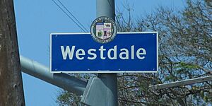
Westdale neighborhood sign
|
|
| Country | |
| State | |
| County | |
| City | |
| Time zone | Pacific |
| Zip Code |
90066
|
| Area code(s) | 310 |
Westdale is a cool neighborhood located in the Westside part of Los Angeles, California. It's a community where people live and grow up. The Mar Vista Community Council helps represent the people living here.
Contents
Exploring Westdale's Location
Westdale is easy to find on a map of Los Angeles. It has clear boundaries that help define where it is.
What are Westdale's Borders?
To the north, you'll find Gateway Boulevard. Palms Boulevard is the southern border. Sawtelle Boulevard is on the east side. Finally, Bundy Drive marks the western edge of Westdale.
Westdale's Interesting History
Westdale has a fascinating past, starting as a large ranch. It later became a planned community.
From Ranch to Neighborhood
Long ago, this area was known as Stephen's Ranch. It was covered with citrus orchards and fields of beans. In 1947, a real estate developer named Paul Trousdale decided to build a new neighborhood here.
Designing the Homes
Paul Trousdale hired a talented architect, Allen Siple, to design the houses. They worked together on other projects too. These included Tahquitz River Estates in Palm Springs and Trousdale Estates in Beverly Hills.
Building a Community
Trousdale first built 450 single-story homes. These were part of a planned community called tract homes. Many of the first families were soldiers returning from World War II. They used the GI Bill to help them move to Southern California after serving in the Pacific Theater. Over time, two more groups of homes were added to Westdale.
Westdale Today
Today, Westdale is a thriving neighborhood with many homes and a strong community spirit.
Homes and Gardens in Westdale
Now, there are about 900 homes in Westdale. Most of them were built in the 1940s. Many gardens still have old citrus trees. These trees are a reminder of the original orchards.
Popular Home Styles
The homes in Westdale show different architecture styles. You can see Ranch-style homes, which are often long and low. There are also homes in the American Colonial Revival style. Other styles include Monterey Colonial Revival and Regency Revival.
Community News
The Westdale Homeowners' Association helps keep the community connected. They publish a newsletter called The Westdale Villager. This newsletter comes out four times a year.
 | Isaac Myers |
 | D. Hamilton Jackson |
 | A. Philip Randolph |


