Westhope, North Dakota facts for kids
Quick facts for kids
Westhope, North Dakota
|
|
|---|---|

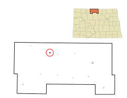
Location of Westhope, North Dakota
|
|
| Country | United States |
| State | North Dakota |
| County | Bottineau |
| Founded | 1903 |
| Area | |
| • Total | 0.32 sq mi (0.84 km2) |
| • Land | 0.32 sq mi (0.84 km2) |
| • Water | 0.00 sq mi (0.00 km2) |
| Elevation | 1,499 ft (457 m) |
| Population
(2020)
|
|
| • Total | 374 |
| • Estimate
(2022)
|
377 |
| • Density | 1,157.89/sq mi (446.43/km2) |
| Time zone | UTC-6 (Central (CST)) |
| • Summer (DST) | UTC-5 (CDT) |
| ZIP code |
58793
|
| Area code(s) | 701 |
| FIPS code | 38-85020 |
| GNIS feature ID | 1036323 |
Westhope is a small city located in Bottineau County, North Dakota, in the United States. In 2020, about 374 people lived there. Westhope was started in 1903. It was built along a Great Northern Railway train line. This line began in Rugby. The city's name comes from the slogan "Hope of the West." Railway officials created this slogan to show their hopes for a successful new town.
Contents
Geography of Westhope
Westhope is a small city, covering an area of about 0.84 square kilometers (0.33 square miles). All of this area is land. There are no large bodies of water within the city limits.
Westhope's Climate
Westhope has a climate with warm summers and cold winters. Temperatures can vary a lot throughout the year. Summers can be quite hot, sometimes reaching over 100 degrees Fahrenheit (38 degrees Celsius). Winters are very cold, with temperatures often dropping below zero. The city also gets a fair amount of rain, especially in the summer months.
| Climate data for Westhope, North Dakota | |||||||||||||
|---|---|---|---|---|---|---|---|---|---|---|---|---|---|
| Month | Jan | Feb | Mar | Apr | May | Jun | Jul | Aug | Sep | Oct | Nov | Dec | Year |
| Record high °F (°C) | 46 (8) |
63 (17) |
77 (25) |
95 (35) |
100 (38) |
101 (38) |
104 (40) |
106 (41) |
99 (37) |
93 (34) |
74 (23) |
58 (14) |
106 (41) |
| Mean daily maximum °F (°C) | 17 (−8) |
23 (−5) |
35 (2) |
57 (14) |
69 (21) |
77 (25) |
82 (28) |
82 (28) |
71 (22) |
55 (13) |
35 (2) |
20 (−7) |
52 (11) |
| Mean daily minimum °F (°C) | −2 (−19) |
4 (−16) |
17 (−8) |
30 (−1) |
42 (6) |
52 (11) |
56 (13) |
54 (12) |
44 (7) |
31 (−1) |
17 (−8) |
2 (−17) |
29 (−2) |
| Record low °F (°C) | −43 (−42) |
−47 (−44) |
−37 (−38) |
−13 (−25) |
13 (−11) |
28 (−2) |
33 (1) |
29 (−2) |
17 (−8) |
−9 (−23) |
−27 (−33) |
−41 (−41) |
−47 (−44) |
| Average precipitation inches (mm) | 0.52 (13) |
0.46 (12) |
0.84 (21) |
1.09 (28) |
2.35 (60) |
3.42 (87) |
2.88 (73) |
2.01 (51) |
1.39 (35) |
1.29 (33) |
0.67 (17) |
0.53 (13) |
17.45 (443) |
Westhope's Population and People
The number of people living in Westhope has changed over the years. A census is an official count of the population. The first census recorded 592 people in 1910. The population reached its highest point in 1960 with 824 residents. By 2020, the population was 374 people.
| Historical population | |||
|---|---|---|---|
| Census | Pop. | %± | |
| 1910 | 592 | — | |
| 1920 | 439 | −25.8% | |
| 1930 | 521 | 18.7% | |
| 1940 | 460 | −11.7% | |
| 1950 | 575 | 25.0% | |
| 1960 | 824 | 43.3% | |
| 1970 | 705 | −14.4% | |
| 1980 | 741 | 5.1% | |
| 1990 | 578 | −22.0% | |
| 2000 | 533 | −7.8% | |
| 2010 | 429 | −19.5% | |
| 2020 | 374 | −12.8% | |
| 2022 (est.) | 377 | −12.1% | |
| U.S. Decennial Census 2020 Census |
|||
Details from the 2010 Census
In 2010, there were 429 people living in Westhope. These people lived in 190 different homes. Out of these homes, 117 were families. The city had about 1300 people per square mile. Most of the people living in Westhope were White (95.1%). A small number were Native American (1.2%) or Asian (0.2%). Some people (3.3%) were from two or more racial backgrounds.
About 22% of homes had children under 18 living there. More than half of the homes (52.6%) were married couples living together. About 35% of all homes had just one person living there. Nearly 19% of homes had someone aged 65 or older living alone. The average home had 2.15 people, and the average family had 2.78 people.
The average age of people in Westhope in 2010 was 49.5 years old. About 18.6% of residents were under 18. About 23.3% of residents were 65 years old or older. The city had slightly more males (50.6%) than females (49.4%).
See also

- In Spanish: Westhope (Dakota del Norte) para niños

