Westminster, Western Australia facts for kids
Quick facts for kids WestminsterPerth, Western Australia |
|||||||||||||||
|---|---|---|---|---|---|---|---|---|---|---|---|---|---|---|---|

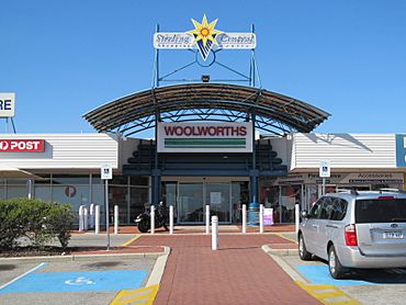
Stirling Central Shopping Centre
|
|||||||||||||||
| Postcode(s) | 6061 | ||||||||||||||
| Area | 2.4 km2 (0.9 sq mi) | ||||||||||||||
| Location | 11 km (7 mi) N of Perth CBD | ||||||||||||||
| LGA(s) | City of Stirling | ||||||||||||||
| State electorate(s) | Balcatta | ||||||||||||||
| Federal Division(s) | Cowan | ||||||||||||||
|
|||||||||||||||
Westminster is a friendly suburb located about 12 kilometres north of Perth, which is the capital city of Western Australia. It's part of the City of Stirling local government area.
Westminster used to be the southern part of another suburb called Balga. But in 1995, people living there asked for it to have its own name. They chose "Westminster" because that was the name of the original land estate before houses were built there. From 1936 to 1955, a road called "Westminster Boulevard" even ran through the area.
Today, Westminster has its own shopping centre called Stirling Central. You'll also find public and private primary schools here, along with several parks and places to play. Getting around is easy with regular bus services that travel along Wanneroo Road and through the middle of the suburb. These buses are run by Transperth, with services from Path Transit and Swan Transit.
Getting Around Westminster: Bus Services
Westminster is well-connected by many bus routes, making it easy for residents to travel to different parts of Perth. These buses are part of the Transperth network.
Bus Routes Serving Westminster
- Route 354: Travels from Mirrabooka Bus Station to Flinders Square. It uses Ravenswood Drive.
- Route 371: Connects Warwick Station to Morley Bus Station. This route goes along Ravenswood Drive, Marloo Road, and Princess Road.
- Routes 374 and 376: These buses run from Mirrabooka Bus Station to Whitfords Station. They use Mirrabooka Avenue.
- Route 375: Goes from Mirrabooka Bus Station to Alexander Heights Shopping Centre. It travels along Ravenswood Drive, Majella Road, and Arkana Road.
- Route 384: Links Mirrabooka Bus Station to Perth Busport (the main bus station in Perth). It uses Ravenswood Drive.
- Route 385: A limited-stop service from Perth Busport to Kingsway City. It uses Amelia Street, Marloo Road, and Princess Road.
- Route 386: A regular service from Perth Busport to Kingsway City, also using Amelia Street, Marloo Road, and Princess Road.
- Routes 387 and 388: Travel from Perth Busport to Warwick Station. They use Wanneroo Road.
- Route 389: Connects Perth Busport to Wanneroo. This route also uses Wanneroo Road.
- Route 415: Runs from Mirrabooka Bus Station to Stirling Station. It uses Ravenswood Drive and Amelia Street.
 | Chris Smalls |
 | Fred Hampton |
 | Ralph Abernathy |

