Hamersley, Western Australia facts for kids
Quick facts for kids HamersleyPerth, Western Australia |
|||||||||||||||
|---|---|---|---|---|---|---|---|---|---|---|---|---|---|---|---|
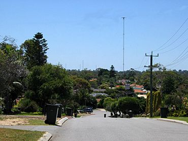
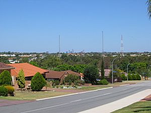
View east from Benjafield Way towards ABC tower
|
|||||||||||||||
| Established | 1968 | ||||||||||||||
| Postcode(s) | 6022 | ||||||||||||||
| Area | 3.347 km2 (1.3 sq mi) | ||||||||||||||
| Location | 14 km (9 mi) NNW of Perth CBD | ||||||||||||||
| LGA(s) | City of Stirling | ||||||||||||||
| State electorate(s) | Kingsley | ||||||||||||||
| Federal Division(s) | Cowan | ||||||||||||||
|
|||||||||||||||
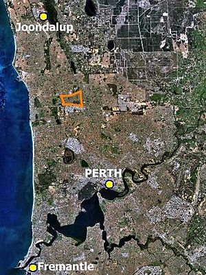
Hamersley is a suburb located about 14 kilometres (9 mi) north of Perth, the capital city of Western Australia. It's also only 6 kilometres (4 mi) from the Indian Ocean. Hamersley is part of the City of Stirling area. It sits next to two big roads: Mitchell Freeway to the west and Reid Highway to the south.
This suburb was built in the late 1960s and 1970s. This happened because the government needed to create more homes as land prices were going up fast. Before it was developed, Hamersley was mostly bushland. It had many native trees like jarrah, marri, and banksia. Some small farms were also there, growing vegetables and raising chickens.
By 1974, just six years after the first homes were built, Hamersley had its own community hall. It even had an annual parade and fair that was shown on TV and radio! There was also a local newspaper called the Hamersley Gazette. As other areas grew, Hamersley became a stable, settled suburb.
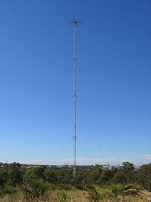
Today, you can still find large areas of natural bushland in Hamersley. The biggest is around the 180-metre (590 ft) tall ABC radio tower. This tower broadcasts AM radio stations across Perth. It was built in 1939 and is a well-known landmark.
Contents
Discover Hamersley's Location
Hamersley is in the northern part of Perth, Western Australia. It is part of the City of Stirling. The suburb is about 6 kilometres (4 mi) from the Indian Ocean.
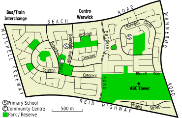
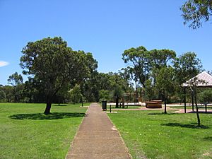
Its boundaries are the Mitchell Freeway to the west. To the south, you'll find Reid Highway and the Balcatta industrial area. Wanneroo Road is to the east, and Beach Road is to the north. The suburb is split into two parts by Erindale Road. Hamersley was one of the first Perth suburbs to use a special design. Many of its smaller streets end in cul-de-sacs, which are connected by parks and pathways.
Hamersley covers about 3.267 square kilometres (1.261 sq mi). It is generally about 29 metres (95 ft) above sea level. However, some parts, especially around Rannoch Circle, are much higher. These spots can be 50 to 55 metres (164 to 180 ft) above sea level. From these higher areas, you can get amazing views of the city and the hills. Some lucky homes can even see glimpses of the ocean!
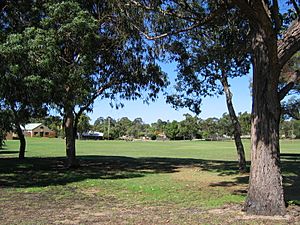
A large bushland area surrounds the ABC radio tower. This area is restricted and covers 14.4% of the suburb. Many parks and natural bushland spots are also spread throughout Hamersley. The biggest are Aintree-Eglinton Reserve and Rannoch-Tay-Earn Reserve. Rannoch-Tay-Earn Reserve has native bushland with paths for walking.
Streets in western Hamersley are often named after towns in England. In eastern Hamersley, streets are named after places in the Scottish Highlands. Some streets, like those in the southwest, are named after famous British racing drivers from the 1920s and 1930s.
Hamersley's Natural Environment
The soil in Hamersley is a yellow-brown sand. It's not very fertile. This sand is made of tiny quartz grains. Underneath the sand is Tamala Limestone. This sand was likely formed from coastal sand blown by wind thousands of years ago.
Below the sand are older rocks from the Perth Basin. The sand holds a lot of clean groundwater. This water supply is refilled by rainfall.
Hamersley's natural environment would have been open forests. These forests had Eucalyptus marginata (Jarrah) and Corymbia calophylla (Marri) trees. The lower plants included different types of Banksia and Allocasuarina fraseriana (Western Sheoak). Many types of shrubs also grew here, like Jacksonia sternbergiana (Stinkwood) and Acacia cyclops (Coastal Wattle). In 2006, a rare plant called Jacksonia sericea (Waldjumi) was found in two reserves in eastern Hamersley.
Hamersley's Past
How Hamersley Got Its Name
Hamersley was named after the Hamersley family. They arrived in Western Australia in 1837. They lived in Guildford. While they probably never visited the modern Hamersley area, they owned a lot of land nearby. In 1869, they built a summer home in what is now North Beach, which is 6 kilometres (4 mi) west.
The name "Hamersley" first described a part of the Perth Road District in 1906. This "Hamersley Ward" was a huge area. It covered what is now Hamersley, Carine, North Beach, and other nearby suburbs. Because of this, many places in North Beach, like a primary school and golf course, were also called Hamersley. This caused some confusion when the new Hamersley suburb started to be built in 1968.
The suburb was officially named Hamersley on 24 October 1975. However, it had been a postal area since 1971.
Early Days of Hamersley
Before Europeans arrived, Hamersley was home to the Mooro people. They were an Indigenous Australian group. They traveled around the lakes and wetlands near the coast.
When the Swan River Colony was set up, land was given to settlers. Southern Hamersley became part of a large land grant in 1829. This area was hard to reach for a long time. The only building was a cottage on Old Balcatta Road. By the late 1930s, some parts of the suburb were cleared for small farms. In 1939, the ABC built its 180-metre (590 ft) radio tower on Wanneroo Road. This tower broadcasts AM and shortwave radio.
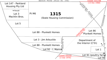
Northern Hamersley was also part of a large land grant. It was given to the Midland Railway Company in the 1890s. Not much happened there until the State Housing Commission took over the land in 1950. In 1962, a farmer wanted to use the northern half of the suburb for a sheep run. But the local leader said no, because the land would soon be needed for houses. In 1967, the area was still mostly untouched bushland.
Building the Suburb: Hamersley Development Scheme
In the late 1960s, land prices in Perth were rising very quickly. The Premier of Western Australia, David Brand, set up a committee to solve this problem. One idea was to release 300 hectares (740 acres) of government-owned land in Hamersley and nearby areas. This land had been set aside for future urban growth.
In 1967, it was decided that this land would be used for housing. The plan included building roads, water pipes, and power lines. Developers were given a time limit to build homes. This was to stop people from buying land just to sell it for a higher price later.
In April 1968, the R&I Bank was allowed to start building in northern Hamersley. The first auction of 80 land lots happened on 14 December 1968. The Premier warned buyers to be careful with their bids. Most lots were sold at a reasonable price.
The western part of Hamersley grew steadily. However, the overall development plan faced delays. There were disagreements between different government groups. By 1970, the plan was mostly stopped. But by February 1971, over 1,000 people were already living in the area.
Hamersley's Growth as a Suburb
In 1970, more land in Hamersley was opened up for building. This allowed for new streets to be built. These streets were named after racing drivers.
Between 1971 and 1973, areas were set aside for parks and drainage. New facilities were built quickly. The 1st Hamersley Scout Group started in 1973. The Holy Cross Anglican Church was built in 1974. A community hall opened in 1975. At this time, Hamersley was still on the edge of Perth's developed area. Residents relied on partly built roads and distant shops.
A local newspaper, the Hamersley Gazette, started in 1973. It aimed to help form community groups and get better facilities. For example, an article in 1973 complained about delays in building Erindale Road.
But there were also fun events. The paper reported on the annual Glendale Spring Fair. This fair had activities for kids, marching bands, and a parade. It was even covered live on ABC radio and TV! The fair helped bring the community together. The Hamersley Gazette later became the Stirling Times.
Meanwhile, building started in eastern Hamersley. In 1973, a company bought a poultry farm to build homes. In 1974, the City of Stirling agreed to sell land for new housing developments. Today, only paved paths remain of some of these early roads. These paths are in the Rannoch-Tay-Earn Reserve. By 1975, many homes were being built for veterans. The rest of eastern Hamersley was built over the next few years. By 1981, the suburb was mostly complete. The community hall was upgraded to a full community centre in 1990.
Hamersley's Community
Hamersley is home to many people. In 2021, about 5,209 people lived there. The average age of residents was 39. Most people in Hamersley were born in Australia (69.0%). The next most common birthplaces were England and New Zealand.
The most common jobs for people in Hamersley are professionals, technicians, and trades workers. Many residents work in hospitals, schools, and supermarkets.
Most homes in Hamersley are detached houses (90.5%). Many homes have four or more bedrooms. About 40% of homes are owned outright, meaning they don't have a mortgage. Another 42.7% are owned with a mortgage.
Most households in Hamersley are families (76.7%). This is higher than the state average. About 44% of families are couples with children. The most common backgrounds people identify with are English, Australian, and Irish. Many residents have no religious affiliation. The Holy Cross Hamersley is an Anglican church in the suburb.
Places and Services in Hamersley
Hamersley is mainly a residential area. For shopping, residents usually go to the Warwick Grove shopping centre, which is on its northern edge. The Karrinyup Shopping Centre is also about 7 kilometres (4 mi) away. There's also a light industrial area to the south in Balcatta, which has a large Bunnings Warehouse.
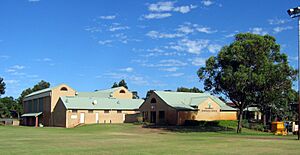
Aintree-Eglinton Reserve is a big grassed area. It has a cricket pitch and lights for Australian rules football. Local sports clubs use these facilities. Inside this reserve is the Hamersley Community Recreation Centre. It started as a community hall in the 1970s and became a full centre in 1990. It has a sports hall with basketball courts, an arts and crafts building, and a community hall for events. There's also a children's centre. Nearby are the 1st Hamersley Scout Group and the Holy Cross Anglican Church.
Many small parks are found throughout Hamersley. They often connect the ends of cul-de-sac streets.
The ABC radio tower is in the southeastern part of Hamersley. It broadcasts ABC AM radio stations. Some residents have complained that the tower causes problems with their TV and phone signals. An investigation in 2010 found that most signals were fine, except for some minor issues with ABC2.
Learning in Hamersley
Hamersley has two state primary schools. Both schools have facilities for pre-primary students. Hamersley students from Years 8 to 12 usually attend Warwick Senior High School.
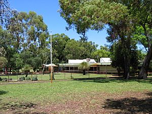
Glendale Primary School was the first school in Hamersley. It opened in 1971 in the western part of the suburb. The school quickly became very busy. This was because its area included Warwick and Greenwood. As new schools were built in those suburbs, Glendale Primary became less crowded. The school and its kindergarten were also used as a meeting place for residents until the community centre opened. In 2016, Glendale Primary School had 248 primary students and 28 pre-primary students.
East Hamersley Primary School opened in February 1979. This was as the eastern part of the suburb developed. In 2006, the school had 109 primary students. Computer studies and Indonesian language are important subjects for students from Years 3 to 6. The West Coast Resource Centre is also located at East Hamersley. It's a special library for teachers in northern Perth.
Getting Around Hamersley
Most people in Hamersley use cars to get to work. In 2021, about 69.6% of working residents drove or were passengers in a car. About 8.0% of working residents used public transport.
Hamersley is surrounded by four main roads. To the south is Reid Highway. This highway connects Hamersley to places like North Beach and Perth Airport. To the west is the Mitchell Freeway. You can get onto the freeway from Reid Highway. The freeway goes south to the Perth city centre and north to Joondalup.
To the north is Beach Road. You can reach the Warwick Grove shopping centre from here. To the east is Wanneroo Road, which also leads to the Perth city centre. Erindale Road cuts through Hamersley. It leads to the Balcatta industrial area and Karrinyup Shopping Centre. Because Reid Highway and Mitchell Freeway are major roads, there are only a few ways to leave Hamersley to the south and west.
Public Transport in Hamersley
Public transport in Hamersley mainly uses Transperth buses. These buses connect to the Warwick railway station. This station is on the Joondalup railway line, which goes to the Perth city centre.
In 2011, 13.9% of Hamersley residents used public transport for work. This was a big increase from 2006. Public transport use was highest near the train station. It was lowest in the southeast, where some residents live far from bus stops.
Currently, the main bus service in the suburb is the 387. It travels along Eglinton Crescent between Warwick and Perth. Eastern Hamersley doesn't have a direct bus service, except for routes along Erindale and Wanneroo Roads. However, services on Wanneroo Road are limited outside of weekdays.
Bus services have changed over the years. In the 1970s, there were shuttle services to connect to other routes. In 1973, new services like the 358 and 359 linked Greenwood to Perth. In 1987, after the Warwick Transfer Station was built, new routes were created.
On 21 March 1993, the Joondalup railway line opened. This led to new bus routes like the 449 and 457. These replaced the 387 service. These services stayed mostly the same until 2011. Then, the 347 was replaced by the current 387. Weekend services were also removed. In 2016, the 449 was also withdrawn. This left Hamersley without weekend bus services.
Bus Routes Serving Hamersley
- 371 Warwick Station to Morley Bus Station – serves Beach Road and Wanneroo Road
- 387 Warwick Station to Perth Busport – serves Beach Road, Belvedere Road and Eglinton Crescent
- 388 Warwick Station to Perth Busport – serves Beach Road and Wanneroo Road
- 389 Wanneroo to Perth Busport – serves Wanneroo Road
- 427 and 428 Warwick Station to Stirling Station – serve Beach Road and Erindale Road
Bus routes serving Beach Road:
 | Ernest Everett Just |
 | Mary Jackson |
 | Emmett Chappelle |
 | Marie Maynard Daly |


