
Gwelup, Western Australia facts for kids
Quick facts for kids GwelupPerth, Western Australia |
|||||||||||||||
|---|---|---|---|---|---|---|---|---|---|---|---|---|---|---|---|

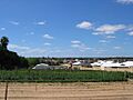
A market garden on North Beach Road, surrounded by residential development
|
|||||||||||||||
| Established | 1970s | ||||||||||||||
| Postcode(s) | 6018 | ||||||||||||||
| Area | 2.9 km2 (1.1 sq mi) | ||||||||||||||
| Location | 12 km (7 mi) from Perth CBD | ||||||||||||||
| LGA(s) | City of Stirling | ||||||||||||||
| State electorate(s) | Carine, Scarborough | ||||||||||||||
| Federal Division(s) | |||||||||||||||
|
|||||||||||||||
Gwelup is a suburb of Perth, the capital city of Western Australia. It is located about 12 kilometers north of Perth's city center. You can easily reach it along the Mitchell Freeway. The local area is managed by the City of Stirling.
Contents
History and Environment in Gwelup
What's in a Name? The Story of Gwelup
The name "Gwelup" comes from a small swamp in the southern part of the suburb. It was inspired by the Noongar word "Gwelgannow." This word means "to shift position." So, Lake Gwelup was known as "the lake that shifts position." The name "Gwelup Swamp" first appeared in official records in 1878.
Lake Gwelup: A Home for Wildlife
On the western side of Gwelup is Lake Gwelup and its surrounding bushland. This area is special because it's one of the few wetlands with mostly natural bushland left. It's a fantastic place for many different animals.
- Birds: You can spot many local and visiting birds here. These include wading birds, birds of prey, and ducks. One of the most beautiful visitors is the Rainbow Bee-eater.
- Other Animals: The lake is also home to various frogs, like the Moaning Frog. You might also see reptiles such as dugites, skinks, and long-necked turtles.
- Plants: The bushland has native trees like Marri, Jarrah, Flooded Gum, and Tuart. There are also several types of Banksia plants. Many colorful wildflowers, including orchids, bloom here every year. You can also find different kinds of fungi.
Aboriginal History in Gwelup
Long ago, Aboriginal people lived around the wetland areas. They hunted for food like kangaroos, emus, snakes, and tortoises. They also caught mudfish and gilgies. Water birds and their eggs were also important food sources. We know that Aboriginal sites existed in several places in the Gwelup-Balcatta region.
From Farms to Homes: Gwelup's Growth
The land near Lake Gwelup was first given to Thomas Mews in 1831. Over time, it changed hands many times. In 1891, Henry Bull from Sydney bought the land.
Henry Bull divided Gwelup into smaller plots in 1898 and 1899. However, the area grew slowly at first. Much of the land was used for market gardens, which are farms that grow vegetables for sale. In the 1960s, an area called The Willows Estate had a peat deposit. Peat is a type of soil that was mined for local farming.
From the 1970s, Gwelup started to change. It went from being a rural area with farms to a modern residential suburb. Today, only a few market gardens along North Beach Road remain. They are a reminder of Gwelup's farming past. The extension of the Mitchell Freeway in the 1980s helped the area develop faster.
The oldest residential part of Gwelup is a triangle-shaped area. It is bordered by Lake Gwelup, Porter Street, and North Beach Road. This area was opened for homes in 1967. Other parts of Gwelup were built and settled later, in the late 1990s. This happened after some swampy areas were drained. There have been discussions about how draining the land and some building practices affect the groundwater. It's important to protect our natural water sources.
Geography and Water in Gwelup
Where is Gwelup?
Gwelup is surrounded by natural and man-made features. Lake Gwelup is to the west. The Mitchell Freeway is to the east. Old Balcatta Road forms the northern boundary. Reid Highway is just a short distance further north. Karrinyup Road is to the south. Because Gwelup has swampy areas and the Lake Gwelup Reserve, some parts of the land are still undeveloped.
Understanding Gwelup's Water
The soils around the lake area are peaty. When these soils are disturbed, they can release certain chemicals into the water. This shows how important it is to manage our land carefully. In the past, the lake used to dry out only occasionally. However, in recent years, it has been much drier. This is likely due to less rainfall and more water being used from the region's water supply. It highlights the need to conserve water.
Who Lives in Gwelup?
According to the 2006 Australian census, Gwelup had 3,239 people living in 1,102 homes. The homes in Gwelup are quite varied. You can find old market garden cottages and modern two-story houses. Newer areas like Karrinyup Waters, Settlers Green, and The Willows have modern, specially designed homes. Along North Beach Road, you can still see some older, rural-style houses. Many of these older homes are being updated or replaced with new developments.
Facilities and Activities in Gwelup
Shopping and Schools in Gwelup
Gwelup is mainly a residential suburb. It has the Gwelup Plaza shopping center for everyday needs. For more shopping and services, the nearby Karrinyup Shopping Centre is a great option.
Gwelup has its own school, Lake Gwelup Primary School. It first opened in 1914 in two wooden buildings that are now considered historical. New buildings are also being constructed. For high school, students in Gwelup usually attend Carine Senior High School.
Fun and Nature in Gwelup
Gwelup has many public open spaces. These are great places for people to meet and enjoy outdoor activities.
- Lake Gwelup Reserve: This is a large reserve, about 75 hectares in size. It includes the 25-hectare Lake Gwelup Wetland. This reserve helps protect an important part of the natural environment. It's also a lovely place for quiet recreation.
- Sports and Paths: You can find tennis courts and cycle paths at the Lake Gwelup Reserve.
Careniup Swamp is another wetland area. It gave its name to nearby Karrinyup. Much of this swamp was drained for housing in the mid-1990s. However, the northwestern part of it has been saved. It is now a wetland and recreation area.
Helping Hands: Friends of Lake Gwelup
There is a volunteer group called "The Friends of Lake Gwelup." They started in 1994. This group works closely with the local government and residents. They help with environmental matters in the area. They also create lists of plants, animals, and fungi found there. The group publishes a newsletter every three months.
Transport in Gwelup
Getting Around Gwelup
Gwelup has good public transport options. The northern and southern parts of the suburb are served by Transperth bus routes 424 and 427. These buses connect Gwelup to Stirling railway station. From Stirling, it's only a nine-minute train ride to Perth's city center. The 424 bus also links Gwelup to Karrinyup Shopping Centre. All bus services are run by Swan Transit.
A Look Back at Gwelup's Buses
In 1925, the North Beach Bus Company started. Alf Lehman began it with crimson-colored buses called charabancs. The James family took over the company in 1928. Back then, REO buses drove on plank roads through the wetlands. These roads connected areas like modern-day Tuart Hill and North Beach. The Metropolitan Transport Trust took over the company in 1961.
Future Transport Ideas
When planners designed the Northern Suburbs Transit System, they thought about future train stations. One possible location for a future station is along the railway line near Wishart Street. This spot is within the Mitchell Freeway reserve. It remains a long-term option for the train line.
Images for kids
-
A market garden on North Beach Road, surrounded by residential development
