Innaloo, Western Australia facts for kids
Quick facts for kids InnalooPerth, Western Australia |
|||||||||||||||
|---|---|---|---|---|---|---|---|---|---|---|---|---|---|---|---|

Saint George Hotel, Barnes Street, Innaloo
|
|||||||||||||||
| Established | 1950s | ||||||||||||||
| Postcode(s) | 6018 | ||||||||||||||
| Area | 3.0 km2 (1.2 sq mi) | ||||||||||||||
| Location | 9 km (6 mi) NNE of Perth CBD | ||||||||||||||
| LGA(s) | City of Stirling | ||||||||||||||
| State electorate(s) | Scarborough | ||||||||||||||
| Federal Division(s) | Curtin | ||||||||||||||
|
|||||||||||||||
Innaloo is a suburb in Perth, the capital city of Western Australia. It is about 9 km (5.6 mi) north-northeast of Perth's city centre. Innaloo is part of the City of Stirling local government area.
This suburb is a well-known residential area. It is home to popular shopping centres like Westfield Innaloo and Westfield Innaloo Megacentre. It is also very close to Perth's biggest cinema complex, Event Cinemas, which has 18 screens.
Contents
What's in a Name?
Innaloo was first called Njookenbooroo. This name came from the local Noongar people. It is believed to be linked to Herdsman Lake or a nearby wet area.
People found the original name hard to say and spell. So, in 1927, a local group asked Daisy Bates for new ideas. She was a welfare worker and expert on Aboriginal cultures. She suggested "Innaloo," which was the name of a woman from Dongara. This name was chosen for the suburb.
Even today, some places in the area still use "Nookenburra," which is another way to spell the original name. The name "Innaloo" sounds a bit like "in a loo," which has led to some jokes. However, efforts to change the suburb's name have not been successful.
A Look Back: Innaloo's History
From Farms to Homes
The land around Innaloo was first given to Thomas Mews in 1831. Later, in 1898, a company called Town Properties of WA divided the land near Njookenbooroo Swamp. They wanted to sell it for market gardens. Over the next few years, they drained the swamp into Herdsman Lake. They dug channels to help with farming.
The company offered land for free if people cleared it and started growing crops. They could then buy the land later. By 1912, local farmers were producing a lot of food, about 25 tonnes each week.
A school called Njookenbooroo School was built in 1915 on Odin Road. This road was connected to the city by a special wooden road. By the 1920s, only ten houses were built in the area. Most of the land was used for grazing animals. More homes were built during World War II. In the 1950s, Metro-Goldwyn-Mayer (MGM) even built a drive-in cinema nearby.
Modern Innaloo Takes Shape
By 1970, most of Innaloo was developed. The suburb became more important because it was close to Scarborough Beach. It was also near the business area of Osborne Park. The Nookenburra Hotel opened in 1962, and a shopping centre in 1967. A civic centre was built in 1966.
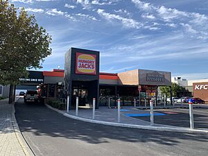
Innaloo is also special because it was home to the very first Hungry Jack's restaurant in Australia, which opened in 1971.
The Mitchell Freeway was extended to Hutton Street in 1981 and to Karrinyup Road in 1984. The shopping centre also had the main bus station for the area. This changed when the Stirling bus and train station was built about a kilometre away in 1992. In 1999, Ellen Stirling Boulevard was built. This new road helped traffic flow better between the freeway and the shops. It was named after the wife of Western Australia's first governor.
Where is Innaloo?
Innaloo is bordered by Karrinyup Road to the north and Huntriss Road to the west. Scarborough Beach Road is its southern border. The Mitchell Freeway is to the east. Most of Innaloo is made up of homes. There are also several small parks.
Some undeveloped land near Stirling station has become a commercial area. This area now includes a new IKEA store. In 2006, a survey showed that Innaloo had 6,470 people. Most homes are single houses built around World War II. However, there are also some duplexes and newer units. Several homes for older people, like Geneff Village, are also in the suburb.
Things to Do in Innaloo
Innaloo has the large Westfield Innaloo shopping centre. Right next to it is the Westfield Innaloo Megacentre. This Megacentre has 20 stores and a grocery shop. Across Scarborough Beach Road, you'll find the Event Cinemas megaplex. There is also a smaller shopping area in Morris Place in the northern part of the suburb. An IKEA store has also been built here. It replaced a smaller store nearby.
Innaloo is home to Perth's biggest cinema complex, the 18-screen Event Cinemas megaplex. This cinema complex also has an arcade with many restaurants and a game centre called Timezone. It started as an MGM drive-in in the 1950s. It was rebuilt in 1990 with 8 screens. Then it became a megaplex, the first in Western Australia, in 1996.
Getting Around Innaloo
Innaloo has good public transport. You can catch buses to Stirling train station on the Joondalup line. Bus routes include the 410, 412, 421, 424, and the 998/999 CircleRoute. The 423 and 425 buses run along Karrinyup Road. Also, the 990 buses connect Scarborough and the Glendalough railway station along Innaloo's southern border.
Before Stirling train station was built, people thought about changing the train line. They considered having it go directly through Innaloo and its shopping area. However, this idea was not chosen. It would have been very expensive and caused environmental issues.
 | Lonnie Johnson |
 | Granville Woods |
 | Lewis Howard Latimer |
 | James West |


