Mirrabooka, Western Australia facts for kids
Quick facts for kids MirrabookaPerth, Western Australia |
|||||||||||||||
|---|---|---|---|---|---|---|---|---|---|---|---|---|---|---|---|

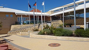
Mirrabooka library
|
|||||||||||||||
| Established | 1954 | ||||||||||||||
| Postcode(s) | 6061 | ||||||||||||||
| Area | 5.0 km2 (1.9 sq mi) | ||||||||||||||
| Location | 12 km (7 mi) N of Perth CBD | ||||||||||||||
| LGA(s) | City of Stirling | ||||||||||||||
| State electorate(s) | Mirrabooka | ||||||||||||||
| Federal Division(s) | Cowan | ||||||||||||||
|
|||||||||||||||
Mirrabooka is a lively suburb located in Perth, Western Australia. It's part of the City of Stirling local government area. In 2021, about 8,000 people lived in Mirrabooka, making it a busy and diverse community.
Contents
History of Mirrabooka
The name "Mirrabooka" has an interesting story. It doesn't come from the local Noongar language. Instead, it's from an Indigenous language in eastern Australia. It's also the name of a town in New South Wales. The name is often linked to the Southern Cross constellation, which is a famous group of stars you can see in the night sky.
In the early 1950s, Mirrabooka was part of a big plan called the "Mirrabooka Project." The idea was to build a large new town, almost like a "satellite city," for up to 60,000 people. This new town would be connected to the nearby Balcatta industrial area. The project included three suburbs: Balga, Nollamara, and Yirrigan. The suburb of Yirrigan was never fully built and stayed mostly bushland. In 1980, it was officially renamed Mirrabooka.
Over the years, Mirrabooka grew quickly. In the 1980s and 1990s, more and more bushland was turned into housing areas. Many new homes were built, especially north of Yirrigan Drive. The Mirrabooka Square shopping centre first opened in 1979. Since then, it has been made bigger several times. A police station was also opened near the shopping centre in 1998 and was expanded in 2015.
Getting Around Mirrabooka
Mirrabooka is a major hub for bus transport in the area. It has its own Mirrabooka bus station, which is a busy place where many bus routes start or pass through. These buses are run by Transperth, helping people get around. You can catch a bus from Mirrabooka to places like Perth, Warwick railway station, and Stirling.
Many bus routes serve different parts of Mirrabooka. For example, routes 374 and 376 cover the western end of Mirrabooka Avenue. Route 377 runs along Honeywell Boulevard, and route 378 uses Australis Avenue. The eastern side, near Alexander Drive, is served by routes 360, 361, and 362. If you're near Beach Road, you can use route 449.
Bus Services
Mirrabooka is well-connected by many bus routes. Here are some of the main ones:
Bus Stations
- Mirrabooka Bus Station
Key Bus Routes
- Routes 67 and 68: These buses go from Mirrabooka Bus Station to Perth Busport. Route 67 uses Yirrigan Drive, and Route 68 goes via Chesterfield Road and Northwood Drive.
- Routes 360, 361, and 362: These routes connect Alexander Heights Shopping Centre (and Ballajura for 362) to Perth Busport. They travel along Alexander Drive.
- Route 371: This bus travels between Morley Bus Station and Warwick Station. It stops at Yirrigan Drive, Mirrabooka Bus Station, and Chesterfield Road.
- Routes 374 and 376: These routes link Mirrabooka Bus Station to Whitfords Station, using Milldale Way and Mirrabooka Avenue.
- Route 377: This bus goes from Mirrabooka Bus Station to Alexander Heights Shopping Centre. It covers Chesterfield Road, Northwood Drive, Boyare Avenue, Honeywell Boulevard, and Beach Road.
- Route 378: From Mirrabooka Bus Station to Alexander Heights, this route uses Chesterfield Road, Northwood Drive, Australis Avenue, and Alexander Drive.
- Route 449: This route connects Malaga to Warwick Station, traveling along Beach Road.
- Route 960: This is a high-frequency bus service from Mirrabooka Bus Station to Curtin University Bus Station, using Yirrigan Drive.
Many other routes also serve Chesterfield Road, including:
- Route 354: Mirrabooka Bus Station to Flinders Square.
- Route 370: Mirrabooka Bus Station to Perth Busport (limited stops).
- Route 375: Mirrabooka Bus Station to Alexander Heights Shopping Centre.
- Route 384: Mirrabooka Bus Station to Perth Busport.
- Route 415: Mirrabooka Bus Station to Stirling Station.
- Route 970: This is a high-frequency service from Mirrabooka Bus Station to Perth Busport.
Schools in Mirrabooka
Mirrabooka is home to several schools, providing education for local children. These include:
- Boyare Primary School (opened in 1991)
- Dryandra Primary School (opened in 1989)
- John Septimus Roe Anglican Community School (opened in 1990)
 | Dorothy Vaughan |
 | Charles Henry Turner |
 | Hildrus Poindexter |
 | Henry Cecil McBay |

