Westport, Oregon facts for kids
Quick facts for kids
Westport, Oregon
|
|
|---|---|

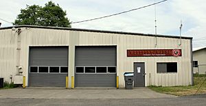
Volunteer Fire Department in Westport
|
|
| Country | United States |
| State | Oregon |
| County | Clatsop |
| Area | |
| • Total | 0.66 sq mi (1.72 km2) |
| • Land | 0.66 sq mi (1.72 km2) |
| • Water | 0.00 sq mi (0.00 km2) |
| Elevation | 16 ft (5 m) |
| Population
(2020)
|
|
| • Total | 319 |
| • Density | 481.15/sq mi (185.90/km2) |
| Time zone | UTC-8 (Pacific (PST)) |
| • Summer (DST) | UTC-7 (PDT) |
| ZIP code |
97016
|
| Area code(s) | 503 and 971 |
| FIPS code | 41-80400 |
| GNIS feature ID | 2611784 |
Westport is a small community located in Clatsop County, Oregon, United States. It sits right on the Columbia River. Even though it's not a big city, it's recognized as a "census-designated place." This means it's a special area that the government counts for population statistics. In 2020, about 319 people lived there.
Contents
Getting Around Westport
Westport is well-connected to other places.
River Connections
- You can take the Wahkiakum County ferry from Westport across the Columbia River.
- This ferry connects Westport to Cathlamet, Washington, which is on the other side of the river.
- The ferry also stops at Puget Island.
Road Connections
- U.S. Route 30 is a main road that goes right through Westport.
- This road can take you west to Astoria.
- If you head east on U.S. Route 30, you'll reach Clatskanie.
Westport's History
Westport got its name from an interesting person who settled there a long time ago.
Who Was John West?
- The community is named after a man called "Captain" John West.
- He was a millwright, which means he built and fixed mills.
- He was also a lumberman, working with wood.
- John West came from Scotland.
- He moved to Canada when he was young and worked in a sawmill there.
- Later, he traveled to Oregon through California during the gold rush of 1849.
Early Businesses in Westport
- In the early 1850s, John West settled in the Westport area.
- He started a sawmill to cut wood.
- He also ran a salmon cannery, which prepared and sealed salmon in cans.
- The Westport post office opened in 1863.
- John West was the very first postmaster for the community.
See also
 In Spanish: Westport (Oregón) para niños
Black History Month on Kiddle
African-American Artists you should know:
 | John T. Biggers |
 | Thomas Blackshear |
 | Mark Bradford |
 | Beverly Buchanan |

All content from Kiddle encyclopedia articles (including the article images and facts) can be freely used under Attribution-ShareAlike license, unless stated otherwise. Cite this article:
Westport, Oregon Facts for Kids. Kiddle Encyclopedia.


