Whapmagoostui facts for kids
Quick facts for kids
Whapmagoostui
ᐙᐱᒫᑯᔥᑐᐃ
|
|
|---|---|

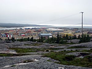
Partial view of the village, as seen from the hills to the east
|
|
| Country | Canada |
| Province | Quebec |
| Region | Nord-du-Québec |
| RCM-Equivalent | Eeyou Istchee |
| Established | 1821 (HBC post) |
| Incorporated | 1978 |
| Government | |
| • Type | Cree territory |
| Area | |
| • Total | 202.49 km2 (78.18 sq mi) |
| • Land | 190.83 km2 (73.68 sq mi) |
| Population
(2021)
|
|
| • Total | 1,022 |
| • Density | 5.2/km2 (13/sq mi) |
| • Change (2016–21) | |
| • Dwellings | 251 |
| Time zone | UTC−05:00 (EST) |
| • Summer (DST) | UTC−04:00 (EDT) |
| Area code(s) | 819 (929 exchange) |
Whapmagoostui is the most northern Cree village in Quebec, Canada. It sits on the coast of Hudson Bay, where the Great Whale River meets the sea.
The name Whapmagoostui (ᐙᐱᒫᑯᔥᑐᐃ) means "place of the beluga" in the Cree language.
About 906 Cree people live here. Next door, in the village of Kuujjuarapik, live about 650 Inuit people. These two groups have lived near each other for a long time. The Inuit usually stayed closer to the coast, while the Cree lived more inland.
You can only reach Whapmagoostui by plane, landing at Kuujjuarapik Airport. In late summer, you can also get there by boat. The closest Cree village, Chisasibi, is about 250 kilometers (155 miles) south.
Contents
Village Names and Meanings
This village was first known as Fort Richmond. Later, its official name became Poste-de-la-Baleine.
The name "Whapmagoostui" comes from the Cree language. It means "place of the beluga whale."
Where is Whapmagoostui?
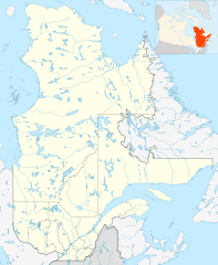
Whapmagoostui is located on the north side of the Great Whale River. This area stretches for about 43 kilometers (27 miles) along the river.
The village does not touch James Bay directly. It is separated from the bay by the nearby village of Kuujjuarapik.
The main part of Whapmagoostui is right next to Kuujjuarapik. They are like two neighborhoods of the same town, even though they are separate communities.
Weather in Whapmagoostui
Whapmagoostui has very cold winters that last a long time. Summers are cool, especially because of the chilly waters of Hudson Bay. Even in August, the warmest month, the average high temperature is only about 16.1 degrees Celsius (61 degrees Fahrenheit).
It can even freeze (0 degrees Celsius or 32 degrees Fahrenheit) in any month of the year! The weather is always affected by whether Hudson Bay is frozen or not.
The village gets less rain and snow from winter to spring. But from June to November, it gets much more. September is usually the wettest month. This is because the cold air from land mixes with the warmer water of Hudson Bay, causing more clouds and rain or snow.
When Hudson Bay freezes over in late November or December, the weather becomes even colder and drier.
| Climate data for Kuujjuarapik (Kuujjuarapik Airport) Climate ID: 7103536; coordinates 55°17′N 77°45′W / 55.283°N 77.750°W; elevation: 12.2 m (40 ft); 1991–2020 normals, extremes 1925–present |
|||||||||||||
|---|---|---|---|---|---|---|---|---|---|---|---|---|---|
| Month | Jan | Feb | Mar | Apr | May | Jun | Jul | Aug | Sep | Oct | Nov | Dec | Year |
| Record high humidex | 3.3 | 5.2 | 10.7 | 21.5 | 33.5 | 38.7 | 41.9 | 38.9 | 36.5 | 27.0 | 12.5 | 6.9 | 41.9 |
| Record high °C (°F) | 3.5 (38.3) |
9.4 (48.9) |
12.1 (53.8) |
21.9 (71.4) |
35.3 (95.5) |
33.9 (93.0) |
37.0 (98.6) |
33.3 (91.9) |
33.9 (93.0) |
23.9 (75.0) |
11.8 (53.2) |
7.2 (45.0) |
37.0 (98.6) |
| Mean daily maximum °C (°F) | −17.2 (1.0) |
−17.2 (1.0) |
−10.5 (13.1) |
−2.5 (27.5) |
6.2 (43.2) |
12.6 (54.7) |
16.6 (61.9) |
16.2 (61.2) |
11.8 (53.2) |
5.8 (42.4) |
−1.1 (30.0) |
−9.8 (14.4) |
0.9 (33.6) |
| Daily mean °C (°F) | −21.3 (−6.3) |
−22.3 (−8.1) |
−16.0 (3.2) |
−7.3 (18.9) |
1.8 (35.2) |
7.6 (45.7) |
11.9 (53.4) |
12.4 (54.3) |
8.5 (47.3) |
3.2 (37.8) |
−3.7 (25.3) |
−13.2 (8.2) |
−3.2 (26.2) |
| Mean daily minimum °C (°F) | −25.3 (−13.5) |
−27.5 (−17.5) |
−21.5 (−6.7) |
−12.2 (10.0) |
−2.7 (27.1) |
2.5 (36.5) |
7.2 (45.0) |
8.6 (47.5) |
5.1 (41.2) |
0.5 (32.9) |
−6.2 (20.8) |
−16.5 (2.3) |
−7.3 (18.9) |
| Record low °C (°F) | −49.4 (−56.9) |
−48.9 (−56.0) |
−45.0 (−49.0) |
−33.9 (−29.0) |
−25.0 (−13.0) |
−7.8 (18.0) |
−2.2 (28.0) |
−1.1 (30.0) |
−6.1 (21.0) |
−15.0 (5.0) |
−28.9 (−20.0) |
−46.1 (−51.0) |
−49.4 (−56.9) |
| Record low wind chill | −62.6 | −62.3 | −58.8 | −44.5 | −30.2 | −12.2 | −7.5 | −5.4 | −9.7 | −21.3 | −38.0 | −56.4 | −62.6 |
| Average precipitation mm (inches) | 29.4 (1.16) |
18.7 (0.74) |
23.5 (0.93) |
20.4 (0.80) |
39.8 (1.57) |
56.6 (2.23) |
82.4 (3.24) |
84.5 (3.33) |
107.6 (4.24) |
83.7 (3.30) |
65.1 (2.56) |
52.4 (2.06) |
664.0 (26.14) |
| Average rainfall mm (inches) | 1.0 (0.04) |
0.1 (0.00) |
2.4 (0.09) |
5.3 (0.21) |
26.1 (1.03) |
55.1 (2.17) |
79.5 (3.13) |
84.2 (3.31) |
107.3 (4.22) |
59.8 (2.35) |
14.4 (0.57) |
0.9 (0.04) |
436.1 (17.17) |
| Average snowfall cm (inches) | 28.9 (11.4) |
19.2 (7.6) |
21.5 (8.5) |
15.1 (5.9) |
12.9 (5.1) |
1.5 (0.6) |
0.0 (0.0) |
0.0 (0.0) |
1.8 (0.7) |
23.2 (9.1) |
53.0 (20.9) |
53.1 (20.9) |
230.0 (90.6) |
| Average precipitation days (≥ 0.2 mm) | 18.3 | 13.4 | 12.6 | 11.3 | 12.4 | 11.7 | 14.4 | 17.2 | 20.5 | 21.4 | 22.6 | 21.1 | 197.0 |
| Average rainy days (≥ 0.2 mm) | 0.43 | 0.25 | 0.95 | 2.6 | 7.7 | 10.6 | 14.0 | 17.1 | 20.2 | 15.5 | 5.2 | 1.1 | 95.5 |
| Average snowy days (≥ 0.2 cm) | 18.2 | 13.3 | 12.2 | 9.5 | 6.8 | 1.9 | 0.0 | 0.0 | 1.1 | 10.0 | 20.6 | 20.8 | 114.3 |
| Average relative humidity (%) (at 1500 LST) | 71.1 | 68.5 | 69.1 | 72.7 | 70.7 | 70.1 | 72.6 | 74.9 | 75.8 | 76.2 | 80.0 | 78.3 | 73.3 |
| Mean monthly sunshine hours | 71.7 | 112.7 | 155.8 | 165.2 | 166.4 | 205.0 | 213.5 | 163.7 | 81.8 | 64.4 | 34.2 | 40.0 | 1,474.3 |
| Percent possible sunshine | 29.6 | 41.5 | 42.5 | 39.0 | 33.2 | 39.4 | 41.0 | 35.2 | 21.3 | 19.8 | 13.5 | 17.8 | 31.2 |
| Source: Environment and Climate Change Canada (sun 1981–2010) | |||||||||||||
History of Whapmagoostui
The Cree people have hunted and fished along the Hudson Bay coast for many years. Europeans arrived in 1820, when the Hudson's Bay Company built a trading post here. It was known by names like Great Whale River House.
Protestant and Catholic churches also set up missions here in the 1880s. In 1895, the government built a weather station. Medical and police services started in the early 1900s. Even with these services, the Cree people did not live here all year. They only used it as a summer camp.
In 1940, the Cree people had to change their way of life. The American army built a military air base here, which meant they could no longer move around freely. The Hudson's Bay Company post closed in 1941.
After World War II, in 1948, the Canadian government took over the military base. In 1955, a radar station was opened. This radar station closed in 1965, but it helped make the village a permanent home for people.
In 1961, the Quebec Government changed the name from Great Whale River to Grande-Baleine. A year later, it was changed again to Poste-de-la-Baleine. On June 28, 1978, the Cree Village Municipality of Poste-de-la-Baleine was officially created. Finally, on May 8, 1996, the village was officially renamed Whapmagoostui.
In 2013, seven young men from the community walked 1600 kilometers (about 994 miles). This journey was called "Nishiyuu" and was done to support the Idle No More movement.
What People Do for Work
Whapmagoostui started because of the Hudson's Bay Company trading post. Later, it became home to a military airport, which is now closed.
Today, Hunting is still a very important part of life and the economy for the people in Whapmagoostui.
Population of Whapmagoostui
Here's how the population has changed over the years:
- 2021: 1,022 people (a small increase of 0.6% from 2016)
- 2016: 1,016 people (an increase of 12.6% from 2011)
- 2011: 874 people (an increase of 7.6% from 2006)
- 2006: 812 people (an increase of 4.4% from 2001)
- 2001: 778 people (an increase of 24.3% from 1996)
- 1996: 626 people (an increase of 23.2% from 1991)
- 1991: 508 people
Getting Around
The only way to get to Whapmagoostui is by flying into the Kuujjuarapik Airport. During the late summer, you can also travel there by boat.
Schools in Whapmagoostui
The Cree School Board runs the Badabin Eeyou School. This school also includes the Meeyow Bee Nooquow School. The school building was built in 1982, and the first high school class graduated in 1989.
 | Claudette Colvin |
 | Myrlie Evers-Williams |
 | Alberta Odell Jones |


