White Hills (Arizona) facts for kids
Quick facts for kids White Hills (Arizona) |
|
|---|---|

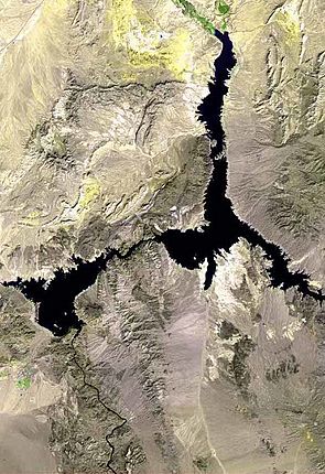
White Hills-(north & central regions) at photo right (bright WHITE), adjacent Lake Mead
|
|
| Highest point | |
| Peak | Table Mountain (Arizona) (south, near terminus) |
| Elevation | 5,175 ft (1,577 m) |
| Dimensions | |
| Length | 28 mi (45 km) N-S |
| Width | 11 mi (18 km) E-W (variable) |
| Geography | |
| Country | United States |
| Communities | White Hills, Arizona, Temple Bar, Arizona and Dolan Springs, Arizona |
The White Hills are a group of hills located in northern Mohave County, Arizona. These hills are found north of the Cerbat Mountains. They stretch south from the Colorado River near Lake Mead. To their west is the Detrital Valley, and to their east are the Gold Basin and the upper Hualapai Valley. The northern part of the White Hills is inside the Lake Mead National Recreation Area.
The White Hills are divided into three main areas: north, central, and south. The middle of the range is a bit northeast of White Hills, Arizona. Here, you'll find Senator Mountain, which is about 1,563 meters (5,127 feet) tall.
History of the White Hills
The western side of the White Hills became famous in 1892. This was when people discovered gold there! This discovery led to a "gold rush." Many people came hoping to find their fortune.
The Boomtown of White Hills
Because of the gold rush, a new town quickly grew up. This town was also called White Hills. It was a "boomtown," meaning it grew very fast because of a sudden economic activity like mining. The town was about 32 kilometers (20 miles) east of a place called Eldorado Canyon. Eldorado Canyon was important because it had a landing spot for steamboats on the river.
 | Anna J. Cooper |
 | Mary McLeod Bethune |
 | Lillie Mae Bradford |


