Hualapai Valley facts for kids
The Hualapai Valley is a wide, flat area of land, also known as a valley, located in Mohave County, Arizona. It's a cool place to learn about Arizona's geography and history!
Contents
Where is Hualapai Valley?
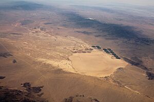
The Hualapai Valley is a special kind of basin called an endorheic basin. This means that any water that flows into it, like from rain or small streams, stays within the valley and doesn't flow out to a larger river or ocean. Instead, the water ends up in a dry lake or a flat, dry area called a playa. In this valley, the water collects in a playa known as Red Lake.
The valley is surrounded by different mountain ranges:
- To the east are the Grand Wash Cliffs and Peacock Mountains.
- To the south are the Hualapai Mountains.
- To the west are the Cerbat Mountains and the White Hills.
The valley stretches from its northern edge near Gold Basin 35°46′57″N 114°07′53″W / 35.78250°N 114.13139°W down to Red Lake. It also extends from the area around Kingman and the Hualapai Mountains 35°10′21″N 113°50′17″W / 35.17250°N 113.83806°W up to Red Lake.
Walapai: A Small Place in the Valley
Within the Hualapai Valley, there's a small community called Walapai. It's an unincorporated area, meaning it's not officially a city or town, but it's a recognized place. Walapai is located along Arizona State Route 66, which used to be part of the famous U.S. Route 66.
This small spot is about 14 miles (23 km) northeast of Kingman, Arizona, and sits along a railroad line. Walapai even has its own post office with the ZIP code 86412.
History of Hualapai Valley
The Hualapai Valley has an interesting past, especially when it comes to early travel and exploration in the American Southwest.
Beale's Wagon Road
Between 1857 and 1858, Lieutenant Edward Fitzgerald Beale led a team to build the very first federal highway in the Southwest. This important road was called Beale's Wagon Road. It roughly followed a path that Lieutenant Amiel Weeks Whipple had planned for a railroad.
Beale's road started by going west across New Mexico Territory through the Flagstaff area. Then, it turned north, passing through places like Peach Springs, Truxton Wash, and right through the Hualapai Valley. It continued on through what would later become Kingman, eventually reaching a crossing point on the Colorado River near where Fort Mohave was built. This road was super important for people traveling and settling in the West!
Hualapai Smith
In the early 1860s, a man named J. L. Smith became quite famous. He was known as Hualapai Smith because he was the very first prospector to explore the Hualapai Valley in Arizona. He explored the area before any other gold or silver seekers arrived, making him a true pioneer of the valley.
 | Sharif Bey |
 | Hale Woodruff |
 | Richmond Barthé |
 | Purvis Young |


