
Whites Creek (Annandale) facts for kids
Quick facts for kids Whites |
|
|---|---|

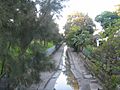
Whites Creek near the corner of Brennan Street and Railway Parade, Annandale
|
|
| Country | Australia |
| State | New South Wales |
| Region | Inner West |
| Local government area | Inner West Council |
| Physical characteristics | |
| Main source | Hamond Hill Farm Annandale |
| River mouth | Rozelle Bay 33°52′26.3″S 151°10′10.0″E / 33.873972°S 151.169444°E |
| Basin features | |
| River system | Port Jackson |
| Designation | New South Wales State Heritage Register |
Whites Creek is a special waterway in Sydney, New South Wales, Australia. It used to be a natural stream, but it was changed into an artificial channel. This was done to help with cleanliness and manage water flow. Today, it is considered a heritage-listed site.
Contents
About Whites Creek Today
Whites Creek is now mostly a storm drain channel. It flows north into Rozelle Bay, which is part of Port Jackson (also known as Sydney Harbour).
Why the Creek Was Changed
In the early days of the colony, around 100 years ago, keeping things clean was a big challenge. Waterways like Whites Creek often became dirty. To fix this, the creek was turned into a concrete channel between 1898 and 1935. This helped manage runoff (water flowing over land) from more and more paved areas.
Special Structures Along the Creek
In 1898, an aqueduct was built over Whites Creek. An aqueduct is like a bridge that carries water or pipes. This one was built to carry sewage (waste water) across the creek. It was also the first time a special building method called the Monier system was used in Australia. This system uses reinforced concrete, which is concrete made stronger with steel bars inside.
Helping the Environment
To make the water cleaner, special wetlands were built next to Whites Creek in 2002. Wetlands are areas of land covered by shallow water, often with specific plants. These wetlands act like a natural filter. They help remove extra nutrients from the water before it flows into Sydney Harbour. This makes the harbour water much healthier.
How Whites Creek Got Its Name
Whites Creek is named after John White. He was a surgeon who came to Australia with the First Fleet. John White was given a piece of land, which he called Hamond Hill Farm. This farm was located south of Parramatta Road, and it's where Whites Creek begins.
Images for kids
-
Whites Creek at Piper Street, Annandale

