Whitesburg, Georgia facts for kids
Quick facts for kids
Whitesburg, Georgia
|
||
|---|---|---|

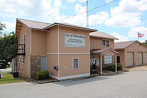
Whitesburg City Hall
|
||
|
||

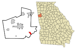
Location in Carroll County and the state of Georgia
|
||
| Country | United States | |
| State | Georgia | |
| County | Carroll | |
| Area | ||
| • Total | 2.80 sq mi (7.24 km2) | |
| • Land | 2.77 sq mi (7.17 km2) | |
| • Water | 0.03 sq mi (0.07 km2) | |
| Elevation | 846 ft (258 m) | |
| Population
(2020)
|
||
| • Total | 596 | |
| • Density | 215.24/sq mi (83.11/km2) | |
| Time zone | UTC-5 (Eastern (EST)) | |
| • Summer (DST) | UTC-4 (EDT) | |
| ZIP code |
30185
|
|
| Area code(s) | 770 | |
| FIPS code | 13-82720 | |
| GNIS feature ID | 0325222 | |
| Website | https://www.whitesburg-ga.com/ | |
Whitesburg is a small town located in Carroll County, Georgia, United States. In 2020, the town had a population of 596 people.
Contents
History of Whitesburg
Early Inhabitants and Creek Nation
Long ago, this area was home to Native American groups. Later, the Creek Confederacy, a group of related tribes, lived here. By the early 1800s, this region was known as the area of the Lower Towns.
A famous Creek leader named William McIntosh, who was of mixed heritage, built a home and a farm here. In 1825, he signed a treaty that gave away Creek lands in Georgia and Alabama to the United States. This went against Creek tribal law, which protected their shared land. Because of this, the Creek National Council ordered his execution in 1825.
Founding of the Town
After the Creek people were moved from their lands, American settlers from the east came to the area. Many of them became farmers who grew just enough food for their families. Whitesburg was officially started by these European-American settlers in 1873.
The town was named after A.J. White, who was an important official for the railroad. The Georgia General Assembly, which is Georgia's state legislature, officially made Whitesburg an incorporated town in 1874. This meant it could have its own local government.
Whitesburg's Location and Landscape
Where is Whitesburg?
Whitesburg is located in the southeastern part of Carroll County, Georgia. It sits right along the Chattahoochee River. The exact location is 33.493434 degrees North and 84.913492 degrees West.
Main Roads and Nearby Cities
The main roads that go through Whitesburg are U.S. Route 27 Alternate and Georgia State Route 5. U.S. Route 27 Alternate runs from the northwest to the southeast. It leads about 12 miles (19 km) northwest to Carrollton, which is the county seat. It also goes about 11 miles (18 km) southeast to Newnan.
Georgia State Route 5 goes northeast from Whitesburg about 23 miles (37 km) to Douglasville. It also heads west about 15 miles (24 km) to Roopville.
Land and Water Area
According to the United States Census Bureau, Whitesburg covers a total area of about 2.8 square miles (7.3 square kilometers). Most of this area, about 2.8 square miles (7.2 square kilometers), is land. A small part, about 0.04 square miles (0.1 square kilometers), is water. This means about 1.07% of the town's total area is water.
Local Waterways
Acorn Creek is a small stream that starts just west of Whitesburg. It flows into the Chattahoochee River. The creek gets its name from Acorn Town, which was a Creek Indian settlement and farm located near where the creek meets the river.
Population of Whitesburg
How Many People Live Here?
The population of Whitesburg has changed over the years. Here's a look at how many people have lived in the town during different census years:
| Historical population | |||
|---|---|---|---|
| Census | Pop. | %± | |
| 1880 | 368 | — | |
| 1890 | 294 | −20.1% | |
| 1900 | 296 | 0.7% | |
| 1910 | 315 | 6.4% | |
| 1920 | 366 | 16.2% | |
| 1930 | 313 | −14.5% | |
| 1940 | 341 | 8.9% | |
| 1950 | 400 | 17.3% | |
| 1960 | 366 | −8.5% | |
| 1970 | 720 | 96.7% | |
| 1980 | 775 | 7.6% | |
| 1990 | 643 | −17.0% | |
| 2000 | 596 | −7.3% | |
| 2010 | 588 | −1.3% | |
| 2020 | 596 | 1.4% | |
| U.S. Decennial Census | |||
In 2000, there were 596 people living in Whitesburg. By the 2020 census, the population was still 596 people.
Households and Families
In 2000, there were 224 households in Whitesburg. A household is a group of people living together in one home. Out of these, 165 were families.
- About 29.9% of households had children under 18 living with them.
- 54.5% were married couples living together.
- 14.3% had a female head of the household with no husband present.
- 25.9% were not families (for example, people living alone).
The average household had about 2.66 people, and the average family had about 3.10 people.
Age and Income
In 2000, the population was spread out by age:
- 25.5% were under 18 years old.
- 10.1% were between 18 and 24 years old.
- 26.8% were between 25 and 44 years old.
- 23.2% were between 45 and 64 years old.
- 14.4% were 65 years or older.
The average age in Whitesburg was 36 years.
In 2000, the average income for a household in Whitesburg was $26,750 per year. For families, the average income was $29,167. By 2022, the average household income had increased to $63,750.
See also
 In Spanish: Whitesburg (Georgia) para niños


