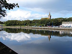
Wick River facts for kids

The Wick River, also known as River Wick, is a river located in Caithness, a part of the Highland region in Scotland. It begins where two smaller streams, the Scouthal Burn and Strath Burn, meet near Achingale Mill. This area is in a unique landscape called the Flow Country. The river then flows into the North Sea at the bay of Wick, passing right through the town of Wick. The river's starting point is about 25 metres above sea level, roughly 11 kilometres west and 2 kilometres north of where it meets the sea.
The area of land that drains into the Wick River, known as its river basin, includes several important lochs (lakes). These are Loch Watten and Loch Tofingall to the west of the river's mouth, and Loch Hempriggs and the Loch of Yarrows to the south and southwest.
River Branches and Streams
A river's branches are called tributaries. These are smaller streams or rivers that flow into a larger river. If you were to travel upstream from the sea, here are some of the main streams and lochs that connect to the Wick River:
- Wick River
- Burn of Newton
- Loch Hempriggs
- Burn of Thrumster
- Loch Hempriggs
- Burn of Newton
* Loch of Yarrows
-
- Burn of Gillock
- Achairn Burn
- Alt Beag-airighe
- Camster Loch
- Toftgunn headwaters
- Loch Burn, Watten
- Scouthal Burn
- Burn of Acharole
- Loch Burn (Toftingall)
- Burn of Acharole
* Loch of Toftingall
-
- Strath Burn
- Kensary Burn
- Camster Burn, also known as Rowens Burn
- Strath Burn
Where the River Meets the Sea
The area where the Wick River meets the sea is called its estuary. This part of the river stretches from near Wick Harbour about 2.5 kilometres inland. In the town of Wick, parts of the river's edge have been built up with artificial embankments. These structures have made the river channel narrower in some places or have created a fixed path for the river where it might otherwise have been a wide, tidal beach area.
Bridges Over the River
The Wick River has several bridges that cross it, including one for trains, three for cars, and two for people walking. Starting from the sea and moving upstream, here they are:
- Harbour Bridge: Located right at the river's mouth in Wick, this bridge connects the town centre with Wick Harbour and Pulteneytown. It replaced an older bridge called the Service Bridge.
- Bridge of Wick: Also in Wick, this is a main road bridge that carries the A99 and A9 roads, which link places like John o' Groats with Latheron and Inverness. It's an extension of Wick’s Bridge Street.
- First Footbridge: About 500 metres west of the Bridge of Wick, a footbridge crosses the river. It uses a small island in the middle of the river to help people cross. This bridge connects walking paths on both sides of the river.
- Second Footbridge: There's another footbridge located roughly halfway between the first footbridge and the railway bridge.
- Railway Bridge: About 300 metres east of Mary Ford, the river is crossed by a railway line. This line connects the towns of Wick and Thurso with the city of Inverness.
- Achingale Bridge: In the village of Watten, the main highway, the A882, crosses the river. This road connects Wick with Thurso.
 | Aurelia Browder |
 | Nannie Helen Burroughs |
 | Michelle Alexander |

