Willard, Kansas facts for kids
Quick facts for kids
Willard, Kansas
|
|
|---|---|

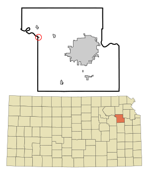
Location within Shawnee County and Kansas
|
|

|
|
| Country | United States |
| State | Kansas |
| County | Shawnee, Wabaunsee |
| Founded | 1880s |
| Incorporated | 1912 |
| Government | |
| • Type | Mayor-Council |
| Area | |
| • Total | 0.11 sq mi (0.28 km2) |
| • Land | 0.11 sq mi (0.28 km2) |
| • Water | 0.00 sq mi (0.00 km2) |
| Elevation | 915 ft (279 m) |
| Population
(2020)
|
|
| • Total | 74 |
| • Density | 670/sq mi (264/km2) |
| Time zone | UTC-6 (CST) |
| • Summer (DST) | UTC-5 (CDT) |
| Area code | 785 |
| FIPS code | 20-79250 |
| GNIS ID | 2397313 |
Willard is a small city located in the state of Kansas, USA. It is found in both Shawnee and Wabaunsee counties. In 2020, about 74 people lived there.
Contents
History of Willard
Willard was a very small place before 1883. It grew when the Rock Island Railroad built train tracks through it. This made Willard a typical railroad town.
In 1887, a railway company built a main line through Willard. This line connected Topeka to Herington. Over the years, different companies owned this railway. Today, many local people still call it the "Rock Island" line.
In the early 1920s, Willard had over 300 people. It was an important place for shipping cattle. During the Great Depression in the 1930s, many businesses closed. The railroad also became less important.
A big flood in 1951, called the Great Flood of 1951, damaged much of Willard. The flood also destroyed the bridge over the Kansas River. This cut off Willard from Rossville until a new bridge was built in 1955.
Geography and Climate
Willard covers a total area of about 0.11 square miles (0.28 square kilometers). All of this area is land.
Willard's Climate
The weather in Willard has hot, humid summers. Winters are usually mild to cool. This type of weather is known as a humid subtropical climate. On climate maps, it is shown as "Cfa".
People of Willard (Demographics)
| Historical population | |||
|---|---|---|---|
| Census | Pop. | %± | |
| 1920 | 134 | — | |
| 1930 | 142 | 6.0% | |
| 1940 | 106 | −25.4% | |
| 1950 | 95 | −10.4% | |
| 1960 | 94 | −1.1% | |
| 1970 | 124 | 31.9% | |
| 1980 | 128 | 3.2% | |
| 1990 | 110 | −14.1% | |
| 2000 | 86 | −21.8% | |
| 2010 | 92 | 7.0% | |
| 2020 | 74 | −19.6% | |
| U.S. Decennial Census | |||
Willard is part of the larger Topeka metropolitan area.
Willard in 2010
In 2010, there were 92 people living in Willard. They lived in 34 households, and 26 of these were families. The city had about 836 people per square mile.
Most people in Willard (92.4%) were White. Some were Native American (2.2%). About 5.4% were from two or more races. About 6.5% of the people were Hispanic or Latino.
In the households, 32.4% had children under 18. Most households (58.8%) were married couples. The average household had 2.71 people. The average family had 3.04 people.
The average age in Willard was 35 years old. About 28.3% of residents were under 18. About 10.9% were 65 or older. There were slightly more females (53.3%) than males (46.7%).
Education in Willard
The public schools in Willard are part of the Kaw Valley USD 321 school district.
See also
 In Spanish: Willard (Kansas) para niños

