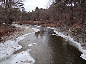
Winhall River facts for kids
Quick facts for kids Winhall River |
|
|---|---|

Winhall River, West River Trail
|
|
| Country | United States |
| State | Vermont |
| Counties | Windham, Bennington |
| Towns/Cities | Stratton, Winhall, Jamaica, Londonderry |
| Physical characteristics | |
| Main source | Stratton, Vermont 788 m (2,585 ft) 43°04′57″N 72°59′36″W / 43.08237°N 72.99325°W |
| River mouth | West River Londonderry, Vermont 290 m (950 ft) 43°09′26″N 72°47′52″W / 43.15736°N 72.79764°W |
| Length | 29.5 km (18.3 mi) |
The Winhall River is a cool river in Vermont, United States. It's about 18 miles (29 kilometers) long. This river is a smaller branch, called a tributary, of the West River. It flows through two counties in Vermont: Windham and Bennington.
Where the Winhall River Flows
The Winhall River starts its journey high up in the Green Mountains. It begins near the western edge of a town called Stratton.
River's Path Through Nature
As the river flows, it heads north. For a while, it forms the eastern border of the Lye Brook Wilderness. This wilderness area is part of the huge Green Mountain National Forest.
A famous hiking path, the Appalachian Trail, even crosses the Winhall River in this area!
Journey Through Towns
After flowing north, the river turns east. It starts to flow down from the high mountains. The Winhall River then passes through the town of Winhall.
It also goes through a small part of Jamaica. Finally, the river reaches Londonderry. Here, it joins the West River in a place called the Ball Mountain Reservoir.
 | Bayard Rustin |
 | Jeannette Carter |
 | Jeremiah A. Brown |

