
West River (Vermont) facts for kids
The West River is a cool river in southern Vermont, United States. It's about 54 miles (87 kilometers) long. The West River is a tributary, which means it's a smaller river that flows into a bigger one. In this case, it flows into the Connecticut River. Sometimes, people have called it "Wantastiquet" or "Waters of the Lonely Way."
Contents
Where the West River Flows
The West River starts way up in the Green Mountains. This is in a town called Mount Holly in Rutland County. From there, it flows south through Windsor County. Then it goes into Windham County, where it turns to flow southeast.
Towns Along the River
As the West River travels, it passes through or near many towns. These towns include Weston, Londonderry, and Jamaica. It also goes by Townshend, Brookline, and Newfane. In Newfane, another river called the Rock River joins the West River. Finally, it flows through Dummerston to Brattleboro. That's where it meets the big Connecticut River.
Dams and Flood Control
The United States Army Corps of Engineers built two large dams on the West River. These dams are called Ball Mountain Dam and Townshend Dam. They were built in 1961 to help control floods. When the river gets too high, these dams can hold back the water. This helps protect towns and homes downstream from flooding.
Lakes Created by Dams
Because of these dams, two lakes were formed on the river. They are called Ball Mountain Lake and Townshend Lake. These lakes are important for managing the river's water.
White Water Boating Fun
The part of the river between Ball Mountain Lake and Townshend Lake is a popular spot for white water boating. This is a fun activity where people paddle rafts or kayaks down rapids. The water for this exciting sport usually comes from special releases from the Ball Mountain Dam. These releases typically happen during one weekend in April and one weekend in September.
River Wildlife
The West River is home to different kinds of fish. In the upper parts of the river, you can find wild native brook trout and wild brown trout. These are beautiful fish that live in clear, cool water. Atlantic salmon also live in most parts of the river. These salmon are amazing fish that travel between rivers and the ocean.
Images for kids
-
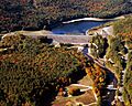
Townshend Lake and Dam on the West River in Windham County, Vermont
-
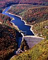
Ball Mountain Lake and Dam on the West River in Windham County, Vermont


