Townshend, Vermont facts for kids
Quick facts for kids
Townshend, Vermont
|
|
|---|---|

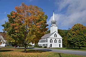
First Congregational Church and Meetinghouse
|
|

Townshend, Vermont
|
|
| Country | United States |
| State | Vermont |
| County | Windham |
| Communities |
|
| Area | |
| • Total | 42.8 sq mi (110.8 km2) |
| • Land | 42.7 sq mi (110.6 km2) |
| • Water | 0.1 sq mi (0.2 km2) |
| Elevation | 810 ft (247 m) |
| Population
(2020)
|
|
| • Total | 1,291 |
| • Density | 28/sq mi (10.7/km2) |
| Time zone | UTC-5 (Eastern (EST)) |
| • Summer (DST) | UTC-4 (EDT) |
| ZIP Codes |
05353 (Townshend)
05359 (West Townshend) |
| Area code(s) | 802 |
| FIPS code | 50-73300 |
| GNIS feature ID | 1462229 |
Townshend is a small town in Windham County, Vermont, United States. It is located in the southeastern part of Vermont. The town got its name from the powerful Townshend family, who were important in British politics. In 2020, about 1,291 people lived in Townshend.
Contents
Townshend's Early History
Townshend was officially started on June 20, 1753. This happened when New Hampshire Governor Benning Wentworth gave a land grant for the area. The town was named after Charles Townshend. He was the Secretary of War for King George III of Britain.
Between 1755 and 1761, people stopped planning to settle in Townshend. This was because of the French and Indian War. The original land grant said the town had to be settled within five years. So, in August 1762, Governor Wentworth gave the land grant again. However, some landowners had already started meeting in 1761. John Hazeltine led the first settlers to the town in May 1761.
Land Disputes and Early Farming
The western border of New Hampshire was not clear back then. There was a big argument about whether Townshend was part of New Hampshire or New York. In 1764, King George III decided the New Hampshire border was the western bank of the Connecticut River. This made settlers in Townshend worried. They feared they would have to pay for their land twice. Luckily, New York only asked for proof of their land. They did not charge the settlers again.
The first farms in Townshend had very rich soil. Farmers could grow crops like wheat, corn, and oats. But they had a problem with tree stumps. These stumps were too strong for their simple farm tools to remove. Other popular crops included potatoes, apples, and pumpkins. Maple syrup was also a big harvest. Farmers raised animals like cattle, sheep, and chickens. Hogs were especially important because they were easy to care for and provided a lot of meat. Several rivers helped water the farms. By 1797, two sawmills and one cloth-making mill were built along these rivers.
Townshend During the Civil War
When the American Civil War began, Townshend had 1,376 people. About 120 men from the town went to fight in the war. They joined the Union Army. To encourage men to volunteer, the town offered cash rewards. These rewards were as high as $500 in 1862. After the war, many soldiers from Townshend left Vermont. This was a common trend across the state. Former soldiers wanted to explore bigger cities around the country. This led to fewer people living in Vermont and a smaller economy.
Leland and Gray Union Middle and High School
Townshend's Middle and High School started as a private school in October 1834. It is one of the oldest secondary schools in Vermont. The first school building was on the east side of the village common. It was named Leland Seminary after Aaron Leland. He was a Baptist preacher from Chester, Vermont.
The school later became Leland and Gray. This happened when Deacon Samuel Gray, a school trustee, gave $800. The school was having trouble paying its bills. In 1894, the original brick building burned down. A new octagonal wooden building was built right away. As a private school, Leland and Gray Seminary had students from all over Vermont and even New England. Many buildings near the school were used as homes for students. Local families also let traveling students live with them.
Changes in Education
Leland and Gray Seminary had a strict curriculum. Students learned basic subjects and classic studies. The school had strong rules about discipline, parent involvement, and dress codes. So, when it became a tuition-free public school in 1968, it was a big change for the town.
The school was renamed Leland and Gray Union Middle and High School. It adopted a new way of teaching called "open classroom." This meant students could choose subjects that interested them. They could also take many different elective classes. This change caused disagreements among families in Townshend. Some preferred the old, traditional way of learning. Others supported the new education system. This tension was similar to what was happening in national politics at the time. It ended when John Newton, the principal for eight years, left in 1977. The building that is now the school started being built in 1970. It cost almost $2 million. More than 750 students have graduated from Leland and Gray.
Townshend's Geography
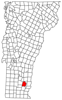
Townshend covers about 42.8 square miles (110.8 km2) of land and water. Most of this area, 42.7 square miles (110.6 km2), is land. Only a small part, 0.1 square mile (0.2 km2), is water. The West River flows through the town. The main village of Townshend is in the south-central part of the town. The community of Harmonyville is just south of it. Both of these communities are located in the valley of the West River.
Population and People
| Historical population | |||
|---|---|---|---|
| Census | Pop. | %± | |
| 1790 | 676 | — | |
| 1800 | 1,083 | 60.2% | |
| 1810 | 1,115 | 3.0% | |
| 1820 | 1,406 | 26.1% | |
| 1830 | 1,386 | −1.4% | |
| 1840 | 1,345 | −3.0% | |
| 1850 | 1,354 | 0.7% | |
| 1860 | 1,376 | 1.6% | |
| 1870 | 1,171 | −14.9% | |
| 1880 | 1,099 | −6.1% | |
| 1890 | 865 | −21.3% | |
| 1900 | 833 | −3.7% | |
| 1910 | 817 | −1.9% | |
| 1920 | 786 | −3.8% | |
| 1930 | 633 | −19.5% | |
| 1940 | 694 | 9.6% | |
| 1950 | 584 | −15.9% | |
| 1960 | 643 | 10.1% | |
| 1970 | 668 | 3.9% | |
| 1980 | 859 | 28.6% | |
| 1990 | 1,019 | 18.6% | |
| 2000 | 1,149 | 12.8% | |
| 2010 | 1,232 | 7.2% | |
| 2020 | 1,291 | 4.8% | |
| U.S. Decennial Census | |||
In 2000, there were 1,149 people living in Townshend. There were 469 households, and 319 of these were families. The population density was about 26.9 people per square mile. Most of the people in Townshend were White (97.82%). A small number were from other racial groups. About 0.70% of the population was Hispanic or Latino.
About 30.7% of households had children under 18 living with them. Most households (54.4%) were married couples. About 25.2% of all households were single individuals. The average household had 2.39 people. The average family had 2.84 people.
The population was spread out by age. About 23.8% were under 18 years old. About 16.4% were 65 years or older. The average age in Townshend was 42 years.
Notable People from Townshend
- Esther Dale, an actress
- Castle Freeman Jr., an author
- Peter W. Galbraith, an ambassador and author
- Ernest Kinoy, a writer for movies and plays
- Clarina I. H. Nichols, a journalist and activist for women's rights and other causes
- Alphonso Taft, who served as Attorney General and Secretary of War for President Ulysses S. Grant
- Marshall H. Twitchell, a Union Army captain and important figure during the Reconstruction period
- Attila Zoller, a guitarist
See also
 In Spanish: Townshend (Vermont) para niños
 | William L. Dawson |
 | W. E. B. Du Bois |
 | Harry Belafonte |


