Jamaica, Vermont facts for kids
Quick facts for kids
Jamaica, Vermont
|
|
|---|---|
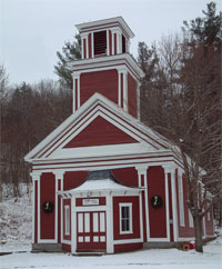
Town Hall
|
|
Jamaica, Vermont
|
|
| Country | United States |
| State | Vermont |
| County | Windham |
| Chartered | 1780 |
| Settled | 1780 |
| Organized | 1781 |
| Communities |
|
| Area | |
| • Total | 49.5 sq mi (128.1 km2) |
| • Land | 49.3 sq mi (127.8 km2) |
| • Water | 0.1 sq mi (0.3 km2) |
| Elevation | 1,135 ft (346 m) |
| Population
(2020)
|
|
| • Total | 1,005 |
| • Density | 20/sq mi (7.9/km2) |
| Time zone | UTC-5 (Eastern (EST)) |
| • Summer (DST) | UTC-4 (EDT) |
| ZIP Codes | |
| Area code(s) | 802 |
| FIPS code | 50-36175 |
| GNIS feature ID | 1462126 |
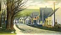
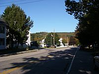
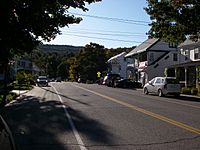
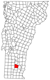
Jamaica is a small town located in Windham County, Vermont, in the United States. In 2020, about 1,005 people lived there. The town includes a few smaller areas like Jamaica Village, East Jamaica, and Rawsonville.
The town's ZIP code is 05343. Jamaica is also home to Jamaica State Park. This park is famous for its beautiful camping spots and fun swimming holes, including Hamilton Falls. The closest big town to Jamaica is Brattleboro.
Contents
A Look at Jamaica's Past
In the early days of America, the land that is now Vermont was claimed by both New York and New Hampshire. In 1767 and 1772, the governor from New York gave out grants for two towns in this area.
How Jamaica Got Its Name
However, in 1777, the Republic of Vermont was formed. They decided to ignore the old land grants. On November 7, 1780, Vermont officially created a new town. They named it Jamaica.
The name "Jamaica" comes from the Natick word for beaver. It is not named after the Caribbean island. The town covers about 42 square miles. Its elevation ranges from 688 feet (210 meters) by the West River to 2,542 feet (775 meters) on The Pinnacle. The original document listed 67 people who received land in Jamaica. Many of their family names are still found among residents today.
Early Settlements and Growth
The first people to settle in Jamaica lived near the West River, close to what is now East Jamaica. The first school was built there in 1791. As new roads and bridges were built towards Manchester, people started moving west. By 1800, the main town center shifted to Jamaica Village.
Over time, about ten small communities grew within the town. Each was surrounded by farms and connected to Jamaica Village by roads. Eventually, there were as many as 14 one-room schools for families in these areas.
Jamaica as a Center for Making Goods
In the early 1800s, Jamaica Village became important for making things. This was because of its location. It was near where the West River and Ball Mountain Brook meet. This spot was perfect for building bridges, dams, and mills. Many dams were built along Ball Mountain Brook. Each dam provided power for at least one mill.
The first store, Noon House, opened in 1803. Its popularity led to the building of Jamaica House in 1814. This was a convenient place for travelers to stay overnight. It was halfway between Manchester and Brattleboro.
Sheep Farming and Economic Changes
Like many towns in Vermont, Jamaica's economy grew with the introduction of Merino sheep in the early 1800s. These sheep thrived on the rocky hillsides. As more sheep were raised, forests were cut down to create open land. However, this good time did not last.
After the Civil War, a difficult economic period began. The demand for wool also dropped. These changes hurt the town's economy.
Jamaica During the Civil War
Many young men from Jamaica joined the Union Army during the Civil War. Windham County sent many soldiers to the 4th Vermont Infantry regiment. Almost all of Jamaica's men joined Company I of this regiment. This group fought in many battles. The Battle of the Wilderness was especially tough for the soldiers from Jamaica.
One soldier from Jamaica, Sergeant Henry W. Downs, was very brave. He was in Company I of the 8th Vermont Infantry. He received the Medal of Honor for his courage during battle.
Floods and the West River Railroad
In 1869, a huge flood destroyed many bridges and damaged every dam on Ball Mountain Brook. Because Jamaica is near the river and gets a lot of snow, it has experienced many damaging floods over the years.
During this time, Jamaica and other towns in the West River Valley worked together. They hoped to improve their economy by building the West River Railroad. The idea for the railroad started in 1867. It was planned to run from Brattleboro to Whitehall, New York.
In 1877, money from the valley towns helped the project move forward. The first part of the railroad was built from Brattleboro to Londonderry. The railroad was never extended further. However, it provided important public transportation for the lower West River Valley until the 1930s. By then, most people owned automobiles.
People of Jamaica
| Historical population | |||
|---|---|---|---|
| Census | Pop. | %± | |
| 1790 | 263 | — | |
| 1800 | 582 | 121.3% | |
| 1810 | 996 | 71.1% | |
| 1820 | 1,313 | 31.8% | |
| 1830 | 1,553 | 18.3% | |
| 1840 | 1,586 | 2.1% | |
| 1850 | 1,606 | 1.3% | |
| 1860 | 1,541 | −4.0% | |
| 1870 | 1,223 | −20.6% | |
| 1880 | 1,252 | 2.4% | |
| 1890 | 1,074 | −14.2% | |
| 1900 | 800 | −25.5% | |
| 1910 | 716 | −10.5% | |
| 1920 | 566 | −20.9% | |
| 1930 | 570 | 0.7% | |
| 1940 | 567 | −0.5% | |
| 1950 | 597 | 5.3% | |
| 1960 | 496 | −16.9% | |
| 1970 | 590 | 19.0% | |
| 1980 | 681 | 15.4% | |
| 1990 | 754 | 10.7% | |
| 2000 | 946 | 25.5% | |
| 2010 | 1,035 | 9.4% | |
| 2020 | 1,005 | −2.9% | |
| U.S. Decennial Census | |||
Based on the census from 2000, there were 946 people living in Jamaica. These people lived in 416 households, and 245 of these were families. The town had about 19 people per square mile. Most of the people living in Jamaica were White (98.41%).
About 27.9% of households had children under 18. Half of the households (50%) were married couples. The average household had 2.27 people, and the average family had 2.88 people.
The population was spread out by age. About 22.3% were under 18. About 31.7% were between 25 and 44. The median age was 38 years old. For every 100 females, there were about 113.5 males.
The average income for a household in Jamaica was $34,917. For families, the average income was $43,333. About 10.1% of the population lived below the poverty line. This included 6.7% of those under 18 and 9.8% of those 65 or older.
Geography and Climate
The United States Census Bureau says that Jamaica covers about 49.5 square miles (128.1 square kilometers). Most of this area is land (49.3 square miles or 127.8 square kilometers). A small part is water (0.1 square miles or 0.3 square kilometers).
The West River flows through the town. You can travel through Jamaica using ![]() Vermont Route 30 and
Vermont Route 30 and ![]() Vermont Route 100.
Vermont Route 100.
Jamaica's Weather
Jamaica has a humid continental climate. This means it has big differences in temperature throughout the year. Summers are warm to hot and often humid. Winters are cold, and sometimes very cold.
Famous People from Jamaica
Many interesting people have connections to Jamaica, Vermont:
- Orion M. Barber – A politician and judge.
- Fred M. Butler – A judge on the Vermont Supreme Court.
- Elliot Cowdin – A businessperson and politician.
- Robert Cowdin – A politician and Civil War officer.
- Henry W. Downs – A Civil War soldier who received the Medal of Honor.
- Edward Fisher – He started The Royal Conservatory of Music in Toronto.
- James Otis Follett – An engineer.
- Florence Lee – A famous silent film actress.
- Aaron Leland – A minister and Lieutenant Governor of Vermont.
- Increase Sumner Lincoln – A minister.
- Eleazer L. Waterman – A judge on the Vermont Superior Court.
- John H. Watson – A Chief Justice of the Vermont Supreme Court.
- Hoyt Henry Wheeler – A Vermont Supreme Court justice and U.S. federal judge.
See also
 In Spanish: Jamaica (Vermont) para niños
 | Sharif Bey |
 | Hale Woodruff |
 | Richmond Barthé |
 | Purvis Young |


