Wolfpen Ridge facts for kids
Quick facts for kids Wolfpen Ridge |
|
|---|---|

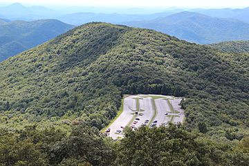
Wolfpen Ridge viewed from Brasstown Bald
|
|
| Highest point | |
| Elevation | 4,561 ft (1,390 m) |
| Geography | |
| Location | Towns / Union counties, Georgia, U.S. |
| Parent range | Blue Ridge Mountains |
| Topo map | USGS Jacks Gap |
| Climbing | |
| First ascent | unknown |
| Easiest route | Hike |
Wolfpen Ridge is a long, raised area of land, like a natural wall, located in the beautiful Blue Ridge Mountains. It stretches across two counties in Georgia, USA: Towns County and Union County. This ridge is special because it's home to some very high points, including Georgia's tallest mountain!
Exploring Wolfpen Ridge
Wolfpen Ridge is a natural landform that runs from south to north. It forms a border between Towns County and Union County in the northern part of Georgia. Imagine a long, wavy line on a map; that's how the ridge looks as it separates these two areas.
High Points of the Ridge
At the northern end of Wolfpen Ridge, you'll find Brasstown Bald. This is the highest point in all of Georgia, standing tall at 4,786 feet (1,459 m) (about 1,459 meters). It's a very famous spot for hikers and visitors.
Further south along the ridge, there's another important peak. This unnamed mountain reaches an elevation of 4,561 feet (about 1,390 meters). This makes it the fifth-highest point in the entire state of Georgia! So, Wolfpen Ridge is not just one high spot, but a series of impressive elevations.
 | Janet Taylor Pickett |
 | Synthia Saint James |
 | Howardena Pindell |
 | Faith Ringgold |

