Woodlawn, Kentucky facts for kids
Quick facts for kids
Woodlawn, Kentucky
|
|
|---|---|

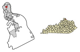
Location of Woodlawn in Campbell County, Kentucky.
|
|
| Country | United States |
| State | Kentucky |
| County | Campbell |
| Area | |
| • Total | 0.06 sq mi (0.15 km2) |
| • Land | 0.06 sq mi (0.15 km2) |
| • Water | 0.00 sq mi (0.00 km2) |
| Elevation | 571 ft (174 m) |
| Population
(2020)
|
|
| • Total | 212 |
| • Density | 3,593.22/sq mi (1,392.36/km2) |
| Time zone | UTC-5 (Eastern (EST)) |
| • Summer (DST) | UTC-4 (EDT) |
| ZIP code |
41071
|
| Area code(s) | 859 |
| FIPS code | 21-84522 |
| GNIS feature ID | 2405785 |
Woodlawn is a small city in Campbell County, Kentucky, United States. It is a "home rule-class city," which means it has the power to manage its own local government. In 2020, the city had a population of 212 people.
Contents
History of Woodlawn
Woodlawn officially became a city on October 17, 1922. This means it gained the right to govern itself and make its own local rules.
Geography and Location
Woodlawn is located in a busy area of Kentucky. It is surrounded by other cities. To the north, west, and south, it borders the city of Newport. To the east and south, it borders Fort Thomas.
A major highway, Interstate 471, runs through the western part of Woodlawn. This highway is important because it connects Woodlawn to Cincinnati, Ohio. It crosses the Ohio River, which is about 2 miles (3.2 km) away.
The United States Census Bureau has measured Woodlawn's total area. The city covers about 0.06 square miles (0.15 square kilometers). All of this area is land.
Population and People
Woodlawn is a small community. The number of people living there has changed over the years.
| Historical population | |||
|---|---|---|---|
| Census | Pop. | %± | |
| 1930 | 296 | — | |
| 1940 | 294 | −0.7% | |
| 1950 | 339 | 15.3% | |
| 1960 | 387 | 14.2% | |
| 1970 | 525 | 35.7% | |
| 1980 | 331 | −37.0% | |
| 1990 | 308 | −6.9% | |
| 2000 | 268 | −13.0% | |
| 2010 | 229 | −14.6% | |
| 2020 | 212 | −7.4% | |
| U.S. Decennial Census | |||
According to the census from 2000, there were 268 people living in Woodlawn. These people lived in 98 different homes. Most of these homes (78 of them) were families.
The population density was about 5,804 people per square mile (2,241 people per square kilometer). This means there were many people living close together in the city.
Most of the people in Woodlawn were White (98.1%). A small number were African American (0.4%) or Native American (0.4%). About 1.1% were from other backgrounds. About 1.5% of the population identified as Hispanic or Latino.
Households and Families
In 2000, about 38.8% of homes in Woodlawn had children under 18 living there. Most homes (63.3%) were married couples living together. About 9.2% of homes had a female head of household without a husband present.
About 17.3% of all homes were made up of single individuals. Only 4.1% of homes had someone living alone who was 65 years old or older. The average number of people in a home was 2.73. For families, the average size was 3.10 people.
Age Distribution
The people in Woodlawn were spread out across different age groups.
- 25.0% of the population was under 18 years old.
- 11.6% was between 18 and 24 years old.
- 31.0% was between 25 and 44 years old.
- 23.9% was between 45 and 64 years old.
- 8.6% was 65 years old or older.
The average age of people in Woodlawn was 35 years old. For every 100 females, there were about 94.2 males. For every 100 females aged 18 and over, there were about 99.0 males.
Income Levels
In 2000, the average income for a home in Woodlawn was $56,042 per year. For families, the average income was $58,571 per year.
Men generally earned more than women. The average income for men was $36,250, while for women it was $27,188. The average income per person in the city was $20,888.
A small number of families (1.4%) and people (3.1%) lived below the poverty line. This included 3.0% of those under 18 years old. No one aged 65 or over was reported to be below the poverty line.
See also
 In Spanish: Woodlawn (Kentucky) para niños
 | Victor J. Glover |
 | Yvonne Cagle |
 | Jeanette Epps |
 | Bernard A. Harris Jr. |

