Worthington, Missouri facts for kids
Quick facts for kids
Worthington, Missouri
|
|
|---|---|
|
Village
|
|

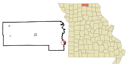
Location of Worthington, Missouri
|
|
| Country | United States |
| State | Missouri |
| County | Putnam |
| Area | |
| • Total | 0.13 sq mi (0.33 km2) |
| • Land | 0.13 sq mi (0.33 km2) |
| • Water | 0.00 sq mi (0.00 km2) |
| Elevation | 807 ft (246 m) |
| Population
(2020)
|
|
| • Total | 47 |
| • Density | 373.02/sq mi (143.53/km2) |
| Time zone | UTC-6 (Central (CST)) |
| • Summer (DST) | UTC-5 (CDT) |
| ZIP code |
63567
|
| Area code(s) | 660 |
| FIPS code | 29-81106 |
| GNIS feature ID | 2399744 |
Worthington is a small village located in the southeastern part of Putnam County, Missouri, in the United States. In 2020, the village had a population of 47 people.
Contents
History of Worthington
The village of Worthington got its name from an early citizen who lived there. A post office has been open in Worthington since 1902. This means people have been sending and receiving mail in the community for over 120 years!
Where is Worthington Located?
Worthington is found on Missouri Route W. It is about half a mile west of the border between Putnam County and Schuyler County. This county line is also along the Chariton River.
Nearby Towns and Roads
- Queen City is about 6.5 miles (10.5 km) to the east. It is located in Schuyler County.
- The community of Martinstown is four miles (6.4 km) to the west. You can find Martinstown on Missouri Route 149.
Size of the Village
According to the United States Census Bureau, Worthington covers a total area of about 0.11 square miles (0.28 square kilometers). All of this area is land.
People Living in Worthington
| Historical population | |||
|---|---|---|---|
| Census | Pop. | %± | |
| 1920 | 327 | — | |
| 1930 | 239 | −26.9% | |
| 1940 | 220 | −7.9% | |
| 1950 | 186 | −15.5% | |
| 1980 | 105 | — | |
| 1990 | 86 | −18.1% | |
| 2000 | 89 | 3.5% | |
| 2010 | 81 | −9.0% | |
| 2020 | 47 | −42.0% | |
| U.S. Decennial Census | |||
Population in 2010
In 2010, the village of Worthington had 81 people living there. These people lived in 33 different homes. About 19 of these homes were families.
The village had a population density of about 736 people per square mile (284 people per square kilometer). There were 52 housing units in total.
Who Lives in Worthington?
- All of the residents in 2010 were White.
- In 36.4% of homes, there were children under 18 years old.
- 45.5% of homes had married couples living together.
- A small number of homes had a single parent.
- About 39.4% of all homes had just one person living there.
- The average home had 2.45 people.
- The average family had 3.26 people.
Age and Gender in 2010
The average age of people in Worthington was 32.5 years old.
- 32.1% of residents were under 18.
- 9.8% were between 18 and 24.
- 22.3% were between 25 and 44.
- 30.8% were between 45 and 64.
- 4.9% were 65 or older.
When it came to gender, 58.0% of the people were male and 42.0% were female.
See also
 In Spanish: Worthington (Misuri) para niños

