Wowan, Queensland facts for kids
Quick facts for kids WowanQueensland |
|||||||||||||||
|---|---|---|---|---|---|---|---|---|---|---|---|---|---|---|---|

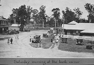
Streetscape, Wowan, 1931
|
|||||||||||||||
| Population | 170 (2021 census) | ||||||||||||||
| • Density | 0.732/km2 (1.90/sq mi) | ||||||||||||||
| Postcode(s) | 4702 | ||||||||||||||
| Area | 232.3 km2 (89.7 sq mi) | ||||||||||||||
| Time zone | AEST (UTC+10:00) | ||||||||||||||
| Location |
|
||||||||||||||
| LGA(s) | Shire of Banana | ||||||||||||||
| State electorate(s) | Callide | ||||||||||||||
| Federal Division(s) | Flynn | ||||||||||||||
|
|||||||||||||||
Wowan is a small town in the Shire of Banana, Queensland, Australia. It is a rural area, meaning it's mostly countryside with farms. In 2021, about 170 people lived in Wowan.
Another small town called Deeford is also part of the Wowan area.
Contents
Where is Wowan Located?
The Dee River flows along the eastern side of the Wowan area. Both Wowan and Deeford towns are in the north-east part of the area. Deeford is close to where the Dee River can be crossed.
There are also a few smaller areas called neighbourhoods within Wowan:
- Buneru (23°57′00″S 150°10′00″E / 23.95°S 150.1666°E)
- Cooneel (23°59′00″S 150°10′00″E / 23.9833°S 150.1666°E)
- Muruguran (24°01′00″S 150°09′00″E / 24.0166°S 150.15°E)
The Leichhardt Highway is a main road that goes right through the Wowan area, passing through the town itself.
What is the History of Wowan?
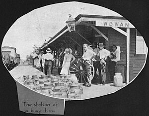
Wowan got its name from its railway station. The name "Wowan" comes from an Aboriginal word for the Australian brush-turkey, which is a type of bird.
The town of Deeford was first called Dundee. It was renamed Deeford on November 6, 1913.
Early Schools in the Area
The first school in the area was Dundee Provisional School, which opened on June 1, 1900. It closed for a short time but reopened in 1905. In 1909, it became Dundee State School and then closed in 1911.
In 1912, two new schools opened. One was Dundee Camp Provisional School, which was for the children of railway workers. This school was in the area that later became Wowan town. The other was Dundee State School, located in what is now Deeford.
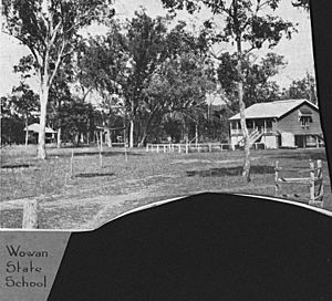
In 1915, Dundee Camp Provisional School changed its name to Wowan Provisional School. A year later, on May 1, 1916, it became Wowan State School. The Dundee State School in Deeford was renamed Deeford State School in 1917 and closed in 1941.
Buneru State School opened on October 5, 1918. After floods in 1928, the school moved to a new location in 1934. It closed in 1962.
The Railway Arrives
The Dawson Valley railway line started being built in 1910. By October 16, 1912, the railway reached the area and ended at the Wowan railway station (23°54′21″S 150°11′53″E / 23.9057°S 150.1980°E). This helped the town of Wowan grow, as it was settled in 1912.
The railway line was later extended on February 2, 1915. It went from Wowan to other stations in the area, including:
- Buneru railway station (23°57′23″S 150°10′24″E / 23.9563°S 150.1733°E)
- Cooneel railway station (23°58′43″S 150°09′37″E / 23.9787°S 150.1603°E)
- Muruguran railway station (24°01′13″S 150°08′42″E / 24.0204°S 150.1450°E)
The railway line from Kabra to Wowan closed on August 1, 1987.
Wowan's Butter Factory
A butter factory opened in Wowan on April 1, 1919. It was run by the Dawson Valley Co-operative Company. This factory helped the local farmers by processing their milk into butter.
Churches in Wowan
The first church built in Wowan was the Wowan Methodist Church. It opened on January 13, 1924. When the Methodist Church joined with other churches in 1977, it became the Wowan Uniting Church. The church building was damaged by floods in 2012. The community decided to move it to the Wowan Museum and fix it up. Now, the Wowan Uniting Church holds its services at the All Souls Anglican Church.
Wowan Museum
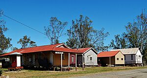
The Wowan Museum started in the old butter factory. Later, it moved to the former railway station. The new Wowan Museum officially opened on October 13, 2012. This was part of the celebrations for the 100th anniversary of the railway coming to Wowan.
What is the Economy of Wowan?
Farms in the Wowan area produce many things, including:
- beef (meat from cattle)
- hay (dried grass for animals)
- grain (like wheat or barley)
- pork (meat from pigs)
- eggs
What Schools are in Wowan?
Wowan State School is a primary school for students from Prep (the first year of school) to Year 6. It is for both boys and girls and is located on Don Street. In 2018, about 30 students attended the school.
There are no high schools in Wowan. For secondary school up to Year 10, students can go to Baralaba State School in Baralaba. For high school up to Year 12, the closest option is Mount Morgan State High School in Mount Morgan.
What Amenities are in Wowan?
The Callide Valley Uniting Church holds its services at the All Souls Anglican Church, located at 19 Don Street (23°54′21″S 150°11′43″E / 23.9058°S 150.1954°E).
What Attractions are in Wowan?
The Wowan and District Museum is a great place to visit. It is located at 2A Dee River Road (corner of Leichhardt Highway, 23°54′36″S 150°11′45″E / 23.9099°S 150.1958°E). You can find it in the old butter factory and former railway station buildings.
What Events Happen in Wowan?
Wowan has an annual agricultural show in August. This is a fun event where people can see farm animals, local produce, and enjoy various activities.
 | Jewel Prestage |
 | Ella Baker |
 | Fannie Lou Hamer |


