
Wrightstown, New Jersey facts for kids
Quick facts for kids
Wrightstown, New Jersey
|
||
|---|---|---|
|
Borough
|
||
.jpg)
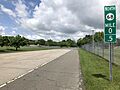
Center of the borough along East Main Street (CR 616)
|
||
|
||
| Motto(s):
"Gateway to Freedom"
|
||

Wrightstown highlighted in Burlington County. Inset map: Burlington County highlighted in the State of New Jersey.
|
||

Census Bureau map of Wrightstown, New Jersey
|
||

Wrightstown, New Jersey
Location in Burlington County, New Jersey

Wrightstown, New Jersey
Location in New Jersey

Wrightstown, New Jersey
Location in the United States
|
||
| Country | ||
| State | ||
| County | ||
| Incorporated | March 26, 1918 | |
| Government | ||
| • Type | Borough | |
| • Body | Borough Council | |
| Area | ||
| • Total | 1.85 sq mi (4.79 km2) | |
| • Land | 1.85 sq mi (4.79 km2) | |
| • Water | 0.00 sq mi (0.00 km2) 0.00% | |
| Area rank | 423rd of 565 in state 33rd of 40 in county |
|
| Elevation | 151 ft (46 m) | |
| Population
(2020)
|
||
| • Total | 720 | |
| • Estimate
(2023)
|
722 | |
| • Rank | 546th of 565 in state 38th of 40 in county |
|
| • Density | 389.1/sq mi (150.2/km2) | |
| • Density rank | 460th of 565 in state 32nd of 40 in county |
|
| Time zone | UTC−05:00 (Eastern (EST)) | |
| • Summer (DST) | UTC−04:00 (Eastern (EDT)) | |
| ZIP Code |
08562
|
|
| Area code(s) | 609 exchanges: 723, 724, 752, 758 | |
| FIPS code | 3400582960 | |
| GNIS feature ID | 0885453 | |
| Website | ||

Wrightstown is a small town, called a borough, located in Burlington County, New Jersey. In 2020, about 720 people lived there. This was a small decrease from 802 people in 2010.
Wrightstown became an official borough on March 26, 1918. It was formed from parts of two nearby areas, New Hanover Township and North Hanover Township. The town is named after John Wright, an early settler who gave the land for the community.
Contents
Geography of Wrightstown
Wrightstown covers an area of about 1.85 square miles (4.79 square kilometers). All of this area is land.
Neighboring Towns and Bases
The borough shares borders with several other towns in Burlington County. These include New Hanover Township, North Hanover Township, Pemberton Township, and Springfield Township. Wrightstown also borders parts of Joint Base McGuire-Dix-Lakehurst, which includes McGuire AFB and Fort Dix.
The Pinelands National Reserve
Wrightstown is part of the New Jersey Pinelands National Reserve. This is a special natural area that protects unique plants and animals. It covers a huge area of 1.1 million acres (4,500 square kilometers). The Pinelands was created by Congress in 1978. It was the first "National Reserve" in the United States.
People and Population
| Historical population | |||
|---|---|---|---|
| Census | Pop. | %± | |
| 1920 | 270 | — | |
| 1930 | 176 | −34.8% | |
| 1940 | 241 | 36.9% | |
| 1950 | 1,199 | 397.5% | |
| 1960 | 4,846 | 304.2% | |
| 1970 | 2,719 | −43.9% | |
| 1980 | 3,031 | 11.5% | |
| 1990 | 3,843 | 26.8% | |
| 2000 | 746 | −80.6% | |
| 2010 | 802 | 7.5% | |
| 2020 | 720 | −10.2% | |
| 2023 (est.) | 722 | −10.0% | |
| Population sources: 1920–2000 1920 1920–1930 1940–2000 1960–2000 2000 2010 2020 |
|||
In 2010, the 2010 United States census counted 802 people living in Wrightstown. These people lived in 309 households. About 189 of these were families. The population density was about 454 people per square mile.
Who Lives in Wrightstown?
The people living in Wrightstown come from many different backgrounds:
- About 47% were White.
- About 21% were Black or African American.
- About 6% were Asian.
- About 19% were from other racial groups.
- About 6% were from two or more races.
- About 28% of the population was Hispanic or Latino.
Age and Households
- About 34% of households had children under 18.
- About 29% were married couples.
- About 22% had a female head of household with no husband.
- About 27% of the population was under 18 years old.
- The average age in Wrightstown was about 30 years old.
Education in Wrightstown
Students in Wrightstown attend public schools through a "sending/receiving" system. This means they go to schools in other nearby towns.
Elementary and Middle School
For students from pre-kindergarten to eighth grade, they attend schools in the New Hanover Township School District. This district serves students from both New Hanover Township and Wrightstown. In the 2018-2019 school year, this district had one school with 177 students.
High School Education
For ninth through twelfth grade, students from Wrightstown go to Bordentown Regional High School. This high school is part of the Bordentown Regional School District. It also serves students from Bordentown City, Bordentown Township, and Fieldsboro Borough. In 2018-2019, the high school had 770 students.
Vocational and Technical Schools
Students from Wrightstown can also attend the Burlington County Institute of Technology. This school offers special training for jobs and technical skills. It has campuses in Medford Township and Westampton Township.
Economy and Environment
EP Henry, a company that makes concrete products, has a factory in Wrightstown. In 2019, this factory started using a new type of cement. This special cement helps reduce carbon emissions by 70%. This is good for the environment.
Transportation

Wrightstown has several important roads. As of 2010, the borough had about 4.35 miles (7.00 kilometers) of roads.
Major Roads
The main highway that goes through Wrightstown is New Jersey Route 68. County Route 545 also passes through the borough.
Public Buses
NJ Transit provides bus service in Wrightstown. The 317 bus route connects Wrightstown to Asbury Park and Philadelphia.
News and History
Wrightstown and its neighbor, Cookstown, were in the news in 2007. This was when six people were arrested for planning an attack against Fort Dix. This event led to increased security around the military bases. This also affected local businesses, especially restaurants that delivered food to the base.
Notable People from Wrightstown
- Daniel V. Asay (1847–1930), a famous iceboat racer.
- Samuel G. Wright (1781–1845), who represented New Jersey in the U.S. House of Representatives in 1845.
Images for kids
-
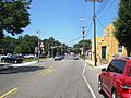
Center of the borough along East Main Street (CR 616)
-
Seal of Wrightstown, New Jersey
-
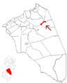
Wrightstown highlighted in Burlington County. Inset map: Burlington County highlighted in the State of New Jersey.
-
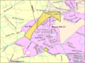
Census Bureau map of Wrightstown, New Jersey
-
Route 68 in Wrightstown
See also
 In Spanish: Wrightstown (Nueva Jersey) para niños
