Yukuhashi, Fukuoka facts for kids
Quick facts for kids
Yukuhashi
行橋市
|
|||||||||||
|---|---|---|---|---|---|---|---|---|---|---|---|

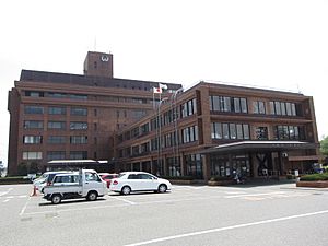
Yukuhashi City Hall
|
|||||||||||
|
|||||||||||
 |
|||||||||||
| Country | Japan | ||||||||||
| Region | Kyushu | ||||||||||
| Prefecture | Fukuoka | ||||||||||
| Area | |||||||||||
| • Total | 70.06 km2 (27.05 sq mi) | ||||||||||
| Population
(April 30, 2023)
|
|||||||||||
| • Total | 72,376 | ||||||||||
| • Density | 1,033.06/km2 (2,675.61/sq mi) | ||||||||||
| Time zone | UTC+09:00 (JST) | ||||||||||
| City hall address | 1-1-1 Chuo, Yukuhashi-shi, Fukuoka-ken 824-8601 | ||||||||||
| Climate | Cfa | ||||||||||
|
|||||||||||
Yukuhashi (pronounced Yoo-koo-hah-shee) is a city in Fukuoka Prefecture, Japan. As of April 30, 2024, about 72,376 people live here. The city covers an area of 70.06 square kilometers.
Contents
Exploring Yukuhashi's Location
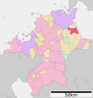
Yukuhashi is in the eastern part of Fukuoka Prefecture. It's about 25 kilometers south of Kitakyushu. The city also sits on the Gulf of Suo, which is part of the Seto Inland Sea. Most of Yukuhashi is flat land. There are a few small mountains near Miyako Town and Kitakyushu City. The city is also close to Hiraodai, a famous area with unique karst rock formations. The Imagawa River flows through the city center. It has a lovely path along its banks. In spring, the cherry blossoms along the river are a beautiful sight.
Cities and Towns Nearby
Yukuhashi is surrounded by several other places in Fukuoka Prefecture:
- Kitakyushu
- Chikujō
- Kanda
- Miyako
Yukuhashi's Weather and Climate
Yukuhashi has a humid subtropical climate. This means it has warm, humid summers and mild winters. The average yearly temperature is about 15.9 degrees Celsius (60.6 degrees Fahrenheit). July is usually the wettest month. The hottest month is August, with temperatures around 27.3 degrees Celsius (81.1 degrees Fahrenheit). January is the coldest, with temperatures around 5.3 degrees Celsius (41.5 degrees Fahrenheit). The highest temperature ever recorded was 38.5 degrees Celsius (101.3 degrees Fahrenheit) in August 2013. The lowest was -8.1 degrees Celsius (17.4 degrees Fahrenheit) in February 1977.
Yukuhashi's Population Over Time
The number of people living in Yukuhashi has grown steadily. In 2020, the population was 71,426. Japan has been keeping track of Yukuhashi's population since 1950.
| Historical population | ||||||||||||||||||||||||||||||||||||||||||||||||||||
|---|---|---|---|---|---|---|---|---|---|---|---|---|---|---|---|---|---|---|---|---|---|---|---|---|---|---|---|---|---|---|---|---|---|---|---|---|---|---|---|---|---|---|---|---|---|---|---|---|---|---|---|---|
|
|
|||||||||||||||||||||||||||||||||||||||||||||||||||
| Yukuhashi population statistics | ||||||||||||||||||||||||||||||||||||||||||||||||||||
A Look into Yukuhashi's Past
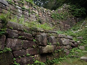
The area where Yukuhashi is now was once part of an old Japanese region called Buzen Province. Long ago, during the Asuka Period (around 538 to 710 AD), special mountain castles called kōgoishi were built here. These castles helped protect the area from possible attacks. Later, during the Edo Period (1603 to 1868), parts of Yukuhashi were controlled by a powerful family called the Kokura Domain. Other parts were directly managed by the Tokugawa Shogunate, which was the military government of Japan at that time.
The modern city of Yukuhashi began on May 1, 1889. On October 10, 1954, Yukuhashi joined with eight nearby villages. These villages were Minoshima, Imamoto, Nakatsu, Izumi, Tsubakishi, Imagawa, Hieda, and Enei. Together, they formed the city we know today.
Yukuhashi's Economy and Jobs
Yukuhashi's economy is mostly based on farming and commercial fishing. It is also a local center for shopping and business. Because it is close to the bigger city of Kitakyushu and has good ways to get around, more and more people who work in Kitakyushu are choosing to live in Yukuhashi. This makes Yukuhashi a "commuter town."
Learning in Yukuhashi
Yukuhashi has many schools for young people. The city government runs eleven public elementary schools and six public junior high schools. For older students, the Fukuoka Prefectural Board of Education operates two public high schools.
Getting Around Yukuhashi
Yukuhashi has good transportation options, making it easy to travel to and from the city.
Train Lines
You can travel by train on two different lines:
- JR Kyushu - Nippō Main Line
- Yukuhashi
- Minami-Yukuhashi
- Shindenbaru
- Heisei Chikuhō Railway - Tagawa Line
- Yukuhashi
- Miyako-Izumi
- Imagawa-Kappa
- Toyotsu
- There is also a special tourist train service called the Coto Coto Train.
Major Roads
Several important highways pass through or near Yukuhashi:
 Higashikyushu Expressway
 National Route 10
 National Route 201
 National Route 496
Places to Visit in Yukuhashi
- Goshogotani Kōgoishi: This is a special historical site. It's where you can see the remains of an ancient mountain fortress.
Famous People from Yukuhashi
- Suematsu Kenchō: He was an important politician during the Meiji era in Japan.
Images for kids
See also
 In Spanish: Yukuhashi (Fukuoka) para niños
 | James Van Der Zee |
 | Alma Thomas |
 | Ellis Wilson |
 | Margaret Taylor-Burroughs |


