
Zagatala District facts for kids
Quick facts for kids
Zagatala District
|
|
|---|---|

Map of Azerbaijan showing Zaqatala District
|
|
| Country | |
| Region | Shaki-Zagatala |
| Established | 8 August 1930 |
| Capital | Zagatala |
| Settlements | 63 |
| Area | |
| • Total | 1,350 km2 (520 sq mi) |
| Population
(2020)
|
|
| • Total | 129,800 |
| • Density | 96.1/km2 (249.0/sq mi) |
| Time zone | UTC+4 (AZT) |
| Postal code |
62
|
Zagatala District (Azerbaijani: Zaqatala rayonu) is one of Azerbaijan's 66 districts. It is located in the northern part of the country. This district is part of the Shaki-Zagatala Economic Region. Zagatala District shares borders with the Balakan and Qakh districts. It also borders the Kakheti region of Georgia and the Russian Republic of Dagestan. The main city and capital of the district is Zagatala. In 2020, about 129,800 people lived here.
Contents
Discovering Zagatala District
Zagatala District is known for its beautiful nature. Unlike some other areas, it has not faced much environmental damage. The district is famous for growing hazelnuts and walnuts. You can also find many mulberry trees here. These trees help keep alive the old tradition of raising silkworms. This tradition was brought to the area a long time ago.
Nature and Wildlife
North of Zagatala city, there is an important nature preserve. It is called the Zagatala State Reserve. This reserve is home to many animals. You can find brown bears, wild boars, and west Caucasian tur here. The tall Caucasus Mountains protect the area from cold northern winds. The mountainsides are covered in forests and have many waterfalls. This makes them great for hiking. Because of its nice climate, Zagatala has become a popular mountain health resort.
Historical Places
Zagatala District also has a rich history. The main city was built in the 1830s by the Russians. It became well-known in the early 1900s. In the villages of Aliabad and Mosul, you can see interesting 19th-century mosques. There are also old forts in villages like Kebeloba, Matsekh, Ekhedi Chardakh, Shaitan-kala, and Jar.
Local Economy
The economy in Zagatala District is mostly based on farming. People grow crops to sell and raise sheep. There is a tea factory and a tobacco processing plant. A large food factory and a silk cocoon drying plant also operate here. The local honey from Zagatala is famous all over Azerbaijan. The local newspaper, Zagatala, is published in the region.
Geography of Zagatala
Zagatala District is located in the northwest of Azerbaijan. It sits in the Ganykh Ayrichay valley. This valley is on the southern slopes of the Major Caucasus Mountains. To the south, it borders Kakheti, Georgia. To the north, it borders Dagestan, Russia. The district also shares borders with Balaken to the west and Gakh to the east.
Zagatala city is the center of the district. It is located about 535 meters (1,755 feet) above sea level. The city is about 445 kilometers (277 miles) away from Baku, the capital of Azerbaijan.
Local Communities
Zagatala District has 31 local communities, called municipalities. The Zagatala municipality includes the city of Zagatala. The Aliabad municipality covers the Aliabad settlement. Many municipalities include more than one village.
For example:
- The Makov municipality includes Makov, Yolayrydj, Pashan, Vohtala, and Abaali villages.
- Goyem municipality has Goyem, Chokek, Sumayly, and Dardoggaz villages.
- Dombabina municipality includes Dombabina, Mamgabina, Bozbina, Mudjagbina, Musgarabina, Gasanbina, and Khanmamedbina villages.
- Chobankol municipality includes Chobankol, Gymyr, and Bazar villages.
In total, these 31 municipalities include one city, one settlement, and 59 villages. As of January 1, 2004, the district had 110,830 people. Most of them, 83,297 people, lived in rural areas.
People of Zagatala
Many different groups of people live in Zagatala city and the surrounding district. These include Azerbaijanis, Avars, Tsakhurs, and Georgians.
Education and Culture
Zagatala District has many places for learning and culture. There are 48 secondary schools, 14 basic schools, and 4 primary schools. The district also has 39 pre-school centers for young children. For older students, there are branches of two universities: the Azerbaijan Teachers' Institute and Baku Islamic University. There is also one college and one vocational school.
For fun and learning outside of school, there are:
- 81 libraries
- 36 clubs
- 27 cultural houses
- 1 theater
- A historical and architectural reserve
- A historical and ethnographical museum
- 1 music school
- A sports school for children
- A chess school
- A creative center for children
Health and Religion
The district has 10 hospitals and 21 village clinics for healthcare. Most people in Zagatala District follow the Islamic faith, mainly Sunni. There is also a smaller group of people who follow the Eastern Orthodox faith. The district has 23 mosques, 1 inn, and 4 hotels.
Fun Things to Do
Zagatala offers many attractions for visitors and locals.
Parks and Squares
- Heydar Park – This large park was started in 1947. It covers 13 hectares (about 32 acres). It is a popular place for families and has many attractions for both kids and adults. It is named after the former president of Azerbaijan, Heydar Aliyev.
- Zarifa Aliyeva Park – Opened in 2008, this park features a statue of Zarifa Aliyeva. She was an Azerbaijani academician and the wife of Heydar Aliyev. The park also has a stage and several fountains.
- Dada Gorgud Square – This square is also known as "Chinar Square." It is famous for a 750-year-old pine tree with a very wide trunk. The square also has 128 stairs built in 1946. Locals call them "Tower staircases."
- Zagatala Stairs – These historic stairs lead to Zagatala Castle and Heydar Park. They were built in 1946 and have 126 steps. They are a popular spot for both visitors and locals.
Historical Sites
- Zagatala Historical-Cultural Reserve (Zagatala Castle) – This castle was built in 1830. Rebels from the "Patyomkin" battleship were once held here as prisoners. Later, Azerbaijanis used it as an army training center. The castle walls are 1.5 meters (about 5 feet) thick. Inside, there are more than 20 historical monuments. Today, it is a museum and is open on working days.
- Zagatala Art Gallery – Located inside the reserve, this gallery opened in 1989. It displays paintings by famous Azerbaijani artists. It also shows artwork created by schoolchildren.
- Car Village – This village is north of Zagatala, on the southern slopes of the Greater Caucasus Mountains. The Bekmez and Zilban rivers flow through it. Car village has an old mosque from the 17th century. It also has the Cigiz tower, which is 10–12 meters (33–39 feet) tall and dates back to the 16th century.
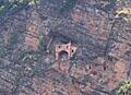
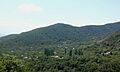
- Yukhari Chardaqlar – This village is about 14 km (9 miles) from the district center. It has a tower from the 13th century and remains of an old Albanian church. There is also a mosque built in the 19th century. Another famous attraction here is "Parigala" (Fairy Castle), which dates back to the 3rd-4th centuries. Reaching this castle is very difficult and usually requires special equipment. Most visitors can only see it from a distance.
Natural Wonders
- Qebizdere Waterfall – This waterfall is 15 meters (about 49 feet) high. It is located near Qebizdere village, north of Mazix village.
- Zagatala State Reserve – This reserve was created in 1929. It is part of the Caucasus mixed forests area. Three rivers, Mazimchay, Balakanchay, and Katekhchay, flow through the reserve. They start in the Greater Caucasus Mountains. The reserve protects unique plants and natural areas from the mountains.
Sports and Festivals
- Zagatala Olympic Sports Complex – Opened in 2006, this complex has many facilities for sports. It includes a swimming pool, sports halls, and a stadium that can hold 3500 people. There is also a tennis court and other areas for different sports.
- Hazelnut Festival – Zagatala is a major producer of hazelnuts in Azerbaijan. Since 2017, the district hosts an annual Hazelnut Festival. During the festival, you can see different types of hazelnuts, walnuts, and chestnuts. There are also many products made from them. Visitors can enjoy handicraft exhibitions and contests. There are also field trips to hazelnut gardens and walnut processing plants.
Villages of Zagatala
- Ashagi Tala
- Uzuntala
- Muxax
- Car
- Aliabad
- Mazikh
- Mosul
- Yukhari Cardakhlar
- Bahmetli
- Zeyem
- Yeni Suvagil
- Yengiyan
- Qandakh
- Muganli
- Maqov
- Mamrukh
- Lakhic
- Kepenekchi
- Kebeloba
- Gozbarakh
- Goyem
- Phaldarli
- Dombabine
- Danachi
- Cobankol
- Ashagi Chardaklar
- Yukhari Tala
- Daghli
Images for kids
-
Perigala
-
Yukhary Chardakhly village


See also
 In Spanish: Raión de Zaqatala para niños
