Örebro Municipality facts for kids
Quick facts for kids
Örebro Municipality
Örebro kommun
|
||
---|---|---|
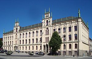
Örebro Town Hall
|
||
|
||
Country | Sweden | |
County | Örebro County | |
Seat | Örebro | |
Area | ||
• Total | 1,628.83 km2 (628.89 sq mi) | |
• Land | 1,380.15 km2 (532.88 sq mi) | |
• Water | 248.68 km2 (96.02 sq mi) | |
Area as of January 1, 2010. | ||
Population
(June 30, 2012)
|
||
• Total | 134,725 | |
• Density | 82.7127/km2 (214.2250/sq mi) | |
Time zone | UTC+1 (CET) | |
• Summer (DST) | UTC+2 (CEST) | |
ISO 3166 code | SE | |
Province | Närke and Västmanland | |
Municipal code | 1880 | |
Website | www.orebro.se |
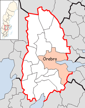
Örebro Municipality (Swedish: Örebro kommun) is a municipality in Örebro County in central Sweden. Its seat is located in the city of Örebro.
The municipality was created from the City of Örebro and surrounding rural municipalities in 1971 and with some areas added in 1974 it had an area of 1,840 km2. In 1995 the municipality was split in two when Lekeberg Municipality was recreated in its boundaries from 1967.
Contents
Localities
Towns and localities with more than 800 inhabitants:
- Örebro 126,604 (seat)
- Hovsta 2,700
- Odensbacken 1,400
- Vintrosa 1,300
- Mosås 900
- Stora Mellösa 800
Others:
- Latorp 500
Demographics
Population development
Year | Population | ||||||||
---|---|---|---|---|---|---|---|---|---|
1970 |
117,696
|
||||||||
1975 |
117,837
|
||||||||
1980 |
116,969
|
||||||||
1985 |
118,043
|
||||||||
1990 |
120,944
|
||||||||
1995 |
119,635
|
||||||||
2000 |
124,207
|
||||||||
2005 |
127,733
|
||||||||
2010 |
135,460
|
||||||||
2015 |
144,200
|
||||||||
2020 |
156,381
|
||||||||
Source: SCB - Folkmängd efter region och år. |
2022 population by district
This is a demographic table based on Örebro Municipality's electoral districts in the 2022 Swedish general election sourced from SVT's election platform, in turn taken from SCB official statistics.
In total there were 117,940 Swedish citizen adults eligible to vote. The political demographics were 52.1% for the left coalition and 46.1% for the right coalition. Indicators are in percentage points except population totals and income.
Location | Residents | Citizen adults |
Left vote | Right vote | Employed | Swedish parents |
Foreign heritage |
Income SEK |
Degree |
---|---|---|---|---|---|---|---|---|---|
% | % | ||||||||
Adolfsberg V | 1,906 | 1,353 | 41.4 | 58.0 | 89 | 87 | 13 | 35,805 | 64 |
Adolfsberg Ö | 1,570 | 1,178 | 48.4 | 51.3 | 88 | 91 | 9 | 32,191 | 63 |
Almby | 1,269 | 963 | 56.2 | 42.7 | 76 | 85 | 15 | 25,262 | 66 |
Asker | 864 | 677 | 36.5 | 62.7 | 86 | 95 | 5 | 23,963 | 25 |
Axberg | 1,842 | 1,396 | 45.3 | 53.1 | 88 | 91 | 9 | 29,153 | 41 |
Baronbackarna | 2,161 | 1,354 | 69.4 | 25.3 | 59 | 34 | 66 | 15,458 | 26 |
Bettorp | 1,163 | 918 | 47.2 | 52.2 | 88 | 77 | 23 | 30,417 | 56 |
Birgitta | 1,549 | 1,344 | 52.5 | 46.0 | 82 | 85 | 15 | 27,287 | 60 |
Björkhaga | 1,775 | 1,318 | 57.8 | 40.8 | 82 | 84 | 16 | 27,970 | 52 |
Brickebacken N | 1,521 | 932 | 60.4 | 33.4 | 54 | 36 | 64 | 13,555 | 32 |
Brickebacken S | 1,935 | 1,190 | 62.5 | 35.2 | 58 | 39 | 61 | 16,218 | 27 |
Brickeberg | 1,627 | 1,126 | 54.9 | 42.7 | 72 | 63 | 37 | 24,912 | 58 |
Bromsplan | 1,423 | 1,191 | 56.4 | 41.8 | 75 | 78 | 22 | 23,551 | 46 |
Brunnsgärdet | 1,749 | 1,408 | 50.6 | 48.3 | 90 | 87 | 13 | 29,178 | 55 |
Centralstationen | 1,515 | 1,292 | 52.5 | 45.6 | 81 | 76 | 24 | 24,989 | 50 |
Centrum | 1,545 | 1,341 | 52.8 | 46.2 | 83 | 83 | 17 | 28,103 | 52 |
Ekeby Almby | 2,416 | 1,487 | 42.9 | 56.8 | 92 | 87 | 13 | 35,895 | 66 |
Eklunda | 1,499 | 1,204 | 46.6 | 52.8 | 84 | 88 | 12 | 31,002 | 60 |
Ervalla | 1,165 | 878 | 43.2 | 55.6 | 86 | 92 | 8 | 26,942 | 33 |
Eyra | 1,488 | 1,268 | 46.2 | 53.0 | 83 | 84 | 16 | 29,488 | 58 |
Gamla Hjärsta | 1,472 | 1,090 | 56.1 | 43.7 | 82 | 76 | 24 | 29,320 | 53 |
Glanshammar-Ödeby | 2,120 | 1,658 | 44.4 | 54.7 | 89 | 94 | 6 | 28,430 | 42 |
Grönpepparparken | 1,876 | 1,373 | 50.4 | 48.8 | 76 | 69 | 31 | 25,582 | 55 |
Gustavsvik | 1,270 | 1,509 | 41.0 | 58.4 | 82 | 77 | 23 | 25,771 | 59 |
Gällersta | 2,032 | 1,487 | 41.2 | 57.3 | 87 | 86 | 14 | 30,551 | 48 |
Hagaby-Ringstorp | 1,481 | 1,157 | 48.5 | 50.8 | 88 | 91 | 9 | 32,276 | 57 |
Hagastrand | 997 | 923 | 55.0 | 44.8 | 81 | 82 | 18 | 25,893 | 48 |
Heden | 1,253 | 966 | 44.3 | 53.5 | 72 | 49 | 51 | 22,644 | 35 |
Hovsta V | 1,525 | 1,080 | 53.4 | 44.9 | 89 | 89 | 11 | 32,113 | 63 |
Hovsta Ö | 1,539 | 1,088 | 52.9 | 45.9 | 87 | 86 | 14 | 29,100 | 55 |
Karla | 1,934 | 1,493 | 58.1 | 39.8 | 76 | 64 | 36 | 21,174 | 44 |
Karlslund | 1,481 | 1,165 | 53.0 | 46.0 | 84 | 76 | 24 | 25,396 | 43 |
Kil | 1,290 | 1,012 | 43.3 | 55.9 | 89 | 91 | 9 | 28,563 | 43 |
Kilsmo-Brevens Bruk | 730 | 599 | 40.4 | 57.9 | 72 | 87 | 13 | 19,985 | 24 |
Krämartorget | 1,439 | 1,274 | 56.8 | 40.7 | 73 | 70 | 30 | 22,231 | 39 |
Ladugårdsängen V | 1,889 | 1,494 | 55.4 | 42.7 | 80 | 79 | 21 | 26,357 | 53 |
Ladugårdsängen Ö | 1,576 | 1,316 | 50.6 | 47.6 | 82 | 78 | 22 | 25,987 | 50 |
Lillkyrka | 920 | 692 | 47.5 | 51.5 | 89 | 93 | 7 | 27,857 | 44 |
Lillån V | 1,816 | 1,283 | 48.3 | 50.2 | 88 | 81 | 19 | 29,486 | 51 |
Lillån Ö | 2,062 | 1,429 | 47.4 | 51.7 | 88 | 87 | 13 | 33,287 | 59 |
Lindhult | 1,777 | 1,312 | 41.1 | 57.6 | 88 | 84 | 16 | 29,209 | 49 |
Lundby N | 1,473 | 1,162 | 58.4 | 39.8 | 82 | 60 | 40 | 23,873 | 39 |
Lundby S | 1,382 | 1,026 | 51.3 | 47.2 | 79 | 62 | 38 | 25,151 | 39 |
Längbrotorg | 1,335 | 1,116 | 56.9 | 41.6 | 79 | 80 | 20 | 24,151 | 45 |
Lännäs-Vinön | 958 | 827 | 42.1 | 56.6 | 81 | 91 | 9 | 23,863 | 37 |
Marieberg | 1,851 | 1,295 | 42.4 | 56.8 | 91 | 90 | 10 | 31,651 | 48 |
Markbacken | 1,358 | 819 | 66.0 | 30.8 | 63 | 32 | 68 | 16,640 | 30 |
Mellringe | 1,553 | 1,171 | 44.7 | 54.2 | 84 | 77 | 23 | 26,806 | 45 |
Mikael | 1,406 | 1,111 | 54.6 | 43.6 | 83 | 83 | 17 | 28,149 | 50 |
Mosås | 2,121 | 1,418 | 41.8 | 57.4 | 88 | 86 | 14 | 30,234 | 48 |
Nasta | 1,642 | 1,280 | 46.9 | 52.4 | 86 | 88 | 12 | 31,105 | 53 |
Norrby | 1,542 | 1,102 | 58.1 | 39.5 | 69 | 65 | 35 | 19,782 | 37 |
Norrbyås | 753 | 588 | 45.2 | 54.2 | 89 | 92 | 8 | 29,773 | 44 |
Nya Hjärsta | 1,603 | 1,171 | 50.6 | 48.3 | 87 | 69 | 31 | 30,415 | 50 |
Nyponlunden | 1,380 | 1,003 | 42.8 | 56.2 | 81 | 49 | 51 | 27,533 | 43 |
Näbbtorget | 1,406 | 1,190 | 55.8 | 42.5 | 67 | 67 | 33 | 19,598 | 39 |
Näsby | 1,756 | 1,254 | 56.8 | 42.5 | 85 | 86 | 14 | 31,771 | 69 |
Odensbacken | 1,741 | 1,374 | 39.9 | 59.0 | 78 | 87 | 13 | 22,217 | 28 |
Olaus Petri | 1,226 | 1,056 | 58.5 | 39.7 | 69 | 70 | 30 | 19,422 | 34 |
Ormesta | 1,339 | 929 | 49.4 | 50.2 | 89 | 90 | 10 | 32,294 | 63 |
Oskarsparken | 1,468 | 1,330 | 52.7 | 46.5 | 78 | 88 | 12 | 26,819 | 57 |
Oxhagen | 2,129 | 1,294 | 67.5 | 25.7 | 57 | 21 | 79 | 14,214 | 25 |
Rinkaby | 718 | 532 | 47.5 | 50.1 | 89 | 94 | 6 | 30,493 | 47 |
Rosta V | 1,549 | 1,160 | 59.5 | 38.1 | 72 | 77 | 23 | 23,840 | 41 |
Rosta Ö | 1,606 | 1,296 | 58.6 | 40.7 | 78 | 79 | 21 | 24,771 | 48 |
Rudbeck | 1,426 | 1,282 | 50.6 | 48.1 | 74 | 81 | 19 | 23,650 | 56 |
Rynninge | 1,545 | 1,207 | 54.8 | 45.1 | 90 | 89 | 11 | 34,291 | 66 |
Rynningeåsen | 1,742 | 1,273 | 59.9 | 39.5 | 85 | 83 | 17 | 29,041 | 65 |
Slottet | 1,137 | 977 | 50.0 | 49.3 | 81 | 84 | 16 | 28,859 | 50 |
Sofia | 1,089 | 991 | 50.4 | 48.6 | 80 | 84 | 16 | 26,250 | 57 |
Solhaga | 1,272 | 1,054 | 65.2 | 33.9 | 79 | 78 | 22 | 22,545 | 45 |
Stadsparken | 1,375 | 1,219 | 50.4 | 49.1 | 78 | 86 | 14 | 26,335 | 58 |
Stora Mellösa | 2,088 | 1,614 | 46.3 | 52.4 | 85 | 94 | 6 | 25,659 | 39 |
Svampen | 1,697 | 1,193 | 56.7 | 41.9 | 83 | 78 | 22 | 27,683 | 56 |
Södermalm | 1,515 | 1,154 | 55.7 | 42.0 | 70 | 59 | 41 | 22,272 | 39 |
Sörby N | 1,380 | 1,157 | 51.0 | 48.3 | 84 | 88 | 12 | 29,786 | 59 |
Sörby S | 1,527 | 1,170 | 53.7 | 45.3 | 79 | 84 | 16 | 28,954 | 62 |
Sörbyängen N | 1,385 | 1,078 | 54.4 | 44.6 | 85 | 81 | 19 | 29,153 | 58 |
Sörbyängen S | 1,483 | 1,110 | 57.2 | 41.9 | 73 | 75 | 25 | 25,249 | 56 |
Tegnér | 1,609 | 1,347 | 56.2 | 42.5 | 79 | 77 | 23 | 25,532 | 52 |
Trängen | 1,465 | 1,136 | 60.9 | 37.6 | 71 | 59 | 41 | 23,751 | 38 |
Tybble | 1,368 | 1,063 | 57.2 | 40.7 | 68 | 64 | 36 | 20,197 | 34 |
Tybblelund | 1,931 | 1,363 | 52.5 | 46.1 | 78 | 86 | 14 | 29,846 | 73 |
Tysslinge-Garphyttan | 1,995 | 1,473 | 52.7 | 46.7 | 84 | 88 | 12 | 27,763 | 41 |
Tysslinge-Latorp | 1,412 | 1,025 | 53.3 | 45.7 | 90 | 94 | 6 | 29,477 | 48 |
Universitetet | 1,873 | 1,474 | 60.4 | 37.5 | 38 | 64 | 36 | 5,477 | 79 |
Universitetssjukhuset | 1,457 | 1,189 | 52.2 | 46.7 | 73 | 78 | 22 | 23,158 | 52 |
Varberga V | 1,965 | 1,094 | 63.5 | 30.8 | 57 | 20 | 80 | 15,537 | 27 |
Varberga Ö | 1,691 | 837 | 56.8 | 36.0 | 52 | 16 | 84 | 12,671 | 28 |
Vasastan M | 1,497 | 1,312 | 55.4 | 43.0 | 77 | 76 | 24 | 21,399 | 43 |
Vasastan N | 1,577 | 1,260 | 56.6 | 40.7 | 76 | 74 | 26 | 23,227 | 40 |
Vasastan S | 1,461 | 1,271 | 54.0 | 45.2 | 80 | 85 | 15 | 24,869 | 49 |
Vintrosa | 2,152 | 1,595 | 44.8 | 54.6 | 89 | 93 | 7 | 28,721 | 41 |
Vivalla N | 2,211 | 1,181 | 67.7 | 16.6 | 49 | 15 | 85 | 12,136 | 23 |
Vivalla V | 2,230 | 922 | 67.8 | 15.4 | 47 | 12 | 88 | 10,671 | 20 |
Vivalla Ö | 2,658 | 1,466 | 70.8 | 11.8 | 46 | 12 | 88 | 11,084 | 17 |
Västhaga | 1,437 | 1,216 | 56.0 | 42.5 | 64 | 68 | 32 | 18,067 | 30 |
Åkullen | 1,384 | 1,162 | 57.1 | 41.2 | 75 | 76 | 24 | 22,641 | 44 |
Örnsro | 1,599 | 1,354 | 56.9 | 41.4 | 72 | 72 | 28 | 22,096 | 42 |
Österplan | 1,283 | 999 | 50.1 | 47.8 | 79 | 82 | 18 | 26,491 | 61 |
Source: SVT |
Elections
From the 1994 election onwards there was a boundary change due to the split with Lekeberg Municipality. The exact results of Sweden Democrats were not listed at a municipal level by SCB from 1988 to 1998 due to the party's small size at the time. "Turnout" denotes the percentage of eligible people casting any ballots, whereas "Votes" denotes the number of valid votes only.
Riksdag
Year | Turnout | Votes | V | S | MP | C | L | KD | M | SD | NyD | Left | Right |
---|---|---|---|---|---|---|---|---|---|---|---|---|---|
1973 | 90.3 | 77,604 | 3.9 | 45.5 | 24.3 | 11.6 | 2.2 | 11.9 | 49.4 | 47.8 | |||
1976 | 91.5 | 80,670 | 4.1 | 44.5 | 23.8 | 12.3 | 1.6 | 13.2 | 48.6 | 49.3 | |||
1979 | 90.0 | 78,995 | 5.2 | 44.3 | 17.3 | 11.9 | 2.0 | 18.2 | 49.5 | 47.4 | |||
1982 | 91.0 | 80,089 | 5.5 | 47.2 | 1.8 | 14.7 | 6.8 | 2.9 | 20.8 | 52.7 | 42.3 | ||
1985 | 89.6 | 80,290 | 5.4 | 44.8 | 1.8 | 11.9 | 16.8 | 18.0 | 50.2 | 46.7 | |||
1988 | 86.5 | 78,201 | 6.4 | 43.2 | 5.0 | 10.1 | 15.3 | 3.9 | 15.0 | 54.6 | 40.4 | ||
1991 | 87.3 | 79,566 | 4.9 | 38.2 | 3.3 | 6.8 | 11.9 | 9.5 | 17.9 | 6.7 | 43.1 | 46.1 | |
1994 | 87.6 | 76,606 | 6.7 | 46.2 | 5.2 | 5.3 | 9.7 | 5.8 | 18.7 | 1.4 | 58.1 | 39.5 | |
1998 | 82.4 | 73,648 | 12.5 | 38.0 | 5.1 | 3.8 | 6.5 | 12.3 | 19.2 | 55.6 | 41.8 | ||
2002 | 82.4 | 76,771 | 8.9 | 41.7 | 5.2 | 4.6 | 14.2 | 10.1 | 12.0 | 1.8 | 55.8 | 40.9 | |
2006 | 83.7 | 80,630 | 6.0 | 38.0 | 6.0 | 6.3 | 8.7 | 8.1 | 21.0 | 3.5 | 50.0 | 44.1 | |
2010 | 86.2 | 87,778 | 5.8 | 34.1 | 5.8 | 4.8 | 7.6 | 7.0 | 26.0 | 5.5 | 45.7 | 45.4 | |
2014 | 86.9 | 92,429 | 5.7 | 32.4 | 8.4 | 5.1 | 5.4 | 6.2 | 21.0 | 11.6 | 46.5 | 37.7 | |
2018 | 87.8 | 98,428 | 8.5 | 31.5 | 4.8 | 8.1 | 5.7 | 7.7 | 17.9 | 14.4 | 52.8 | 45.7 |
Twin towns
Örebro's seven twin towns with the year of its establishing: