Ōfunato facts for kids
Quick facts for kids
Ōfunato
大船渡市
|
|||||||||||||
|---|---|---|---|---|---|---|---|---|---|---|---|---|---|
|
City
|
|||||||||||||

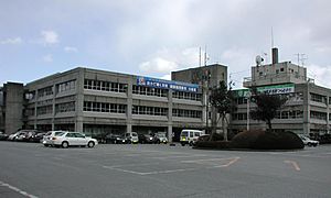
Ōfunato City Hall
|
|||||||||||||
|
|||||||||||||

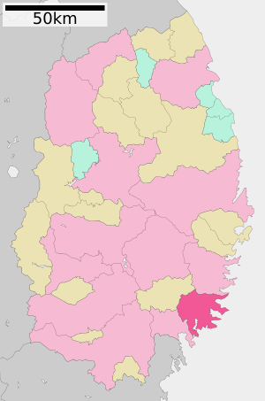
Location of Ōfunato in Iwate Prefecture
|
|||||||||||||
| Country | Japan | ||||||||||||
| Region | Tōhoku | ||||||||||||
| Prefecture | Iwate | ||||||||||||
| Area | |||||||||||||
| • Total | 322.51 km2 (124.52 sq mi) | ||||||||||||
| Population
(30 April 2020)
|
|||||||||||||
| • Total | 35,452 | ||||||||||||
| • Density | 109.925/km2 (284.705/sq mi) | ||||||||||||
| Time zone | UTC+09:00 (Japan Standard Time) | ||||||||||||
| Phone number | 0192-27-3111 | ||||||||||||
| Address | 15, Sakarichō Aza Utsunosawa, Ōfunato-shi, Iwate-ken 022-8501 | ||||||||||||
| Climate | Cfa | ||||||||||||
|
|||||||||||||
Ōfunato (大船渡市, Ōfunato-shi) is a city located in Iwate Prefecture, Japan. As of April 30, 2020, about 35,452 people lived there. The city covers an area of 322.51 square kilometers (124.52 sq mi). This means there were about 110 people per square kilometer.
Contents
Geography and Nature
Ōfunato is in the southeastern part of Iwate Prefecture. It faces the Pacific Ocean to the east. The city has a beautiful coastline.
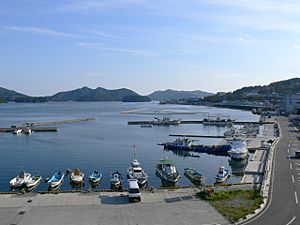
Warm and cold ocean currents meet outside Ōfunato Bay. This helps the commercial fishing industry grow. The city also wants to become a major shipping port.
Kaminari-iwa, on the city's Goishi coastline, is a special place. It's known for its unique sounds. It has been named one of the 100 Soundscapes of Japan. Much of Ōfunato is part of the Sanriku Fukkō National Park. This park protects the area's natural beauty.
Neighboring Towns and Cities
Ōfunato shares its borders with a few other places in Iwate Prefecture:
- Kamaishi
- Rikuzentakata
- Sumita
Climate and Weather
Ōfunato has a humid subtropical climate. This means it has hot summers and cold winters. The average temperature each year is about 11.7°C (53.1°F).
The city gets about 1472 mm (58 inches) of rain every year. September is usually the wettest month. January is the driest. August is the warmest month, with temperatures around 23.2°C (73.8°F). January is the coldest, at about 1.1°C (34.0°F).
| Climate data for Ōfunato, 1991–2020 normals, extremes 1963−present | |||||||||||||
|---|---|---|---|---|---|---|---|---|---|---|---|---|---|
| Month | Jan | Feb | Mar | Apr | May | Jun | Jul | Aug | Sep | Oct | Nov | Dec | Year |
| Record high °C (°F) | 16.8 (62.2) |
17.7 (63.9) |
23.9 (75.0) |
32.0 (89.6) |
34.7 (94.5) |
33.7 (92.7) |
37.0 (98.6) |
37.0 (98.6) |
34.0 (93.2) |
28.2 (82.8) |
22.8 (73.0) |
21.2 (70.2) |
37.0 (98.6) |
| Mean daily maximum °C (°F) | 4.7 (40.5) |
5.6 (42.1) |
9.1 (48.4) |
14.5 (58.1) |
19.1 (66.4) |
22.1 (71.8) |
25.6 (78.1) |
27.2 (81.0) |
24.2 (75.6) |
19.0 (66.2) |
13.3 (55.9) |
7.4 (45.3) |
16.0 (60.8) |
| Daily mean °C (°F) | 1.1 (34.0) |
1.4 (34.5) |
4.4 (39.9) |
9.4 (48.9) |
14.2 (57.6) |
17.9 (64.2) |
21.7 (71.1) |
23.2 (73.8) |
20.0 (68.0) |
14.4 (57.9) |
8.6 (47.5) |
3.5 (38.3) |
11.7 (53.1) |
| Mean daily minimum °C (°F) | −2.4 (27.7) |
−2.3 (27.9) |
0.1 (32.2) |
4.7 (40.5) |
9.9 (49.8) |
14.5 (58.1) |
18.7 (65.7) |
20.1 (68.2) |
16.5 (61.7) |
10.2 (50.4) |
4.1 (39.4) |
−0.2 (31.6) |
7.8 (46.0) |
| Record low °C (°F) | −11.0 (12.2) |
−11.6 (11.1) |
−8.5 (16.7) |
−4.3 (24.3) |
0.2 (32.4) |
3.8 (38.8) |
4.9 (40.8) |
10.2 (50.4) |
4.7 (40.5) |
−0.3 (31.5) |
−4.8 (23.4) |
−9.2 (15.4) |
−11.6 (11.1) |
| Average precipitation mm (inches) | 51.3 (2.02) |
41.0 (1.61) |
103.8 (4.09) |
129.1 (5.08) |
153.9 (6.06) |
174.4 (6.87) |
196.4 (7.73) |
182.1 (7.17) |
200.2 (7.88) |
161.3 (6.35) |
88.6 (3.49) |
61.3 (2.41) |
1,546.7 (60.89) |
| Average snowfall cm (inches) | 13 (5.1) |
14 (5.5) |
8 (3.1) |
1 (0.4) |
0 (0) |
0 (0) |
0 (0) |
0 (0) |
0 (0) |
0 (0) |
1 (0.4) |
9 (3.5) |
45 (18) |
| Average precipitation days (≥ 1.0 mm) | 5.3 | 5.0 | 7.7 | 8.6 | 9.5 | 10.2 | 12.6 | 10.7 | 11.1 | 8.9 | 6.9 | 6.6 | 103.1 |
| Average snowy days | 4.6 | 4.1 | 2.3 | 0.2 | 0 | 0 | 0 | 0 | 0 | 0 | 0.1 | 2.7 | 14 |
| Average relative humidity (%) | 62 | 62 | 62 | 65 | 71 | 79 | 82 | 82 | 80 | 75 | 69 | 65 | 71 |
| Mean monthly sunshine hours | 141.9 | 134.9 | 158.2 | 174.1 | 180.4 | 151.4 | 133.9 | 143.7 | 118.7 | 136.9 | 137.9 | 131.9 | 1,741.4 |
| Source: Japan Meteorological Agency | |||||||||||||
Population Changes
The number of people living in Ōfunato grew until around 1980. Since then, the population has slowly gone down.
| Historical population | ||
|---|---|---|
| Year | Pop. | ±% |
| 1920 | 24,175 | — |
| 1930 | 28,608 | +18.3% |
| 1940 | 32,767 | +14.5% |
| 1950 | 41,589 | +26.9% |
| 1960 | 47,363 | +13.9% |
| 1970 | 48,816 | +3.1% |
| 1980 | 50,132 | +2.7% |
| 1990 | 47,219 | −5.8% |
| 2000 | 45,160 | −4.4% |
| 2010 | 40,737 | −9.8% |
| 2020 | 34,728 | −14.8% |
History of Ōfunato
The area where Ōfunato is today has been settled for a very long time. People lived here even during the Jōmon period (an ancient time in Japan). Archaeologists have found many old shell mounds around Ōfunato Bay.
During the Sengoku period (a time of wars in Japan), different samurai families ruled this area. Later, the Date clan took control. They ruled the Sendai Domain under the Tokugawa shogunate (Japan's military government).
The village of Ōfunato officially became a municipality on April 1, 1889. This was part of a new system for local governments.
Tsunami Events
Ōfunato has been affected by large tsunamis (giant ocean waves) several times.
- In 1896, a 25-meter (82 ft) tsunami hit the area. It caused many deaths.
- In 1933, another powerful earthquake caused a 28-meter (92 ft) tsunami. This wave also caused many deaths.
On April 1, 1952, Ōfunato became a city. Several nearby towns and villages joined it.
- These included Sakari, Akasaki, Takkon, Massaki, Ikawa, and Hikoroichi.
The city became known around the world in 1960. A tsunami from a huge earthquake in Chile reached Ōfunato. On November 15, 2001, the town of Sanriku also merged into Ōfunato.
The 2011 Tōhoku Earthquake and Tsunami
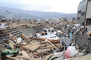
Ōfunato was severely damaged by the 2011 Tōhoku earthquake and tsunami. The tsunami wave was very high, estimated to be 23.6 meters (77.4 ft). Because of the narrow bay, the wave traveled far inland, about 3 kilometers (1.9 mi).
Many buildings were destroyed. However, Ōfunato's theater survived without much damage. It became a safe place for about 250 people who survived the disaster. Around 3,498 homes were destroyed by the tsunami. Sadly, 305 lives were lost.
The city had 58 special places for people to go during an evacuation. But at least six of these places were covered by the tsunami. The story of Ōfunato during this disaster was shown in a British documentary.
Economy and Industry
The main industry in Ōfunato is commercial fishing. This means catching fish and other seafood to sell. Other important industries include making cement and processing wood.
Education in Ōfunato
Ōfunato has several schools for students of different ages:
- Kitasato University has a campus in Sanriku.
- The city government runs 11 public elementary schools.
- There are also five public middle schools.
- The Iwate Prefectural Board of Education operates two public high schools.
- Ōfunato also has one private high school.
Transportation
You can travel to and from Ōfunato by train, highway, and ship.
Railway Lines
The Sanriku Railway Company operates the Sanriku Railway Rias Line.
- Sakari–Rikuzen-Akasaki–Ryōri–Koishihama–Horei–Sanriku–Yoshihama
The East Japan Railway Company (JR East) used to run the Ōfunato Line. However, these train services are now stopped. They have been replaced by a BRT (bus system that acts like a train).
- Hosoura–Shimofunato–Ōfunato–Sakari
Major Highways
Several important roads pass through Ōfunato:
 Sanriku Expressway
 National Route 45
 National Route 107
 National Route 397
Port Facilities
The Port of Ōfunato is an important seaport for the city.
Local Attractions
Ōfunato has many interesting places to visit:
- Goishi Coast: This beautiful coastline is a National Place of Scenic Beauty. It's also a Natural Monument.
- Sangojima: Another National Place of Scenic Beauty.
- Shimofunato Shell Mound, Ōhora Shell Mound, Takonoura Shell Mound: These are ancient sites where archaeologists found old shell middens. They are National Historic Sites.
International Connections
Ōfunato has a special connection with a city in Spain:
 Palos de la Frontera, Huelva, Spain, has been a sister city since August 12, 1992.
Famous People from Ōfunato
Some well-known people come from Ōfunato:
- Yoshinobu Fujiwara, a politician.
- Tochinohana Hitoshi, a sumo wrestler.
- Nanae Sasaki, a marathon runner.
See also
 In Spanish: Ōfunato (Iwate) para niños


