
Kamaishi, Iwate facts for kids
Quick facts for kids
Kamaishi
釜石市
|
|||||||||||||
|---|---|---|---|---|---|---|---|---|---|---|---|---|---|

Kamaishi City Hall, May 2013
|
|||||||||||||
|
|||||||||||||

Location of Kamaishi in Iwate Prefecture
|
|||||||||||||

Kamaishi
Location in Japan
|
|||||||||||||
| Country | Japan | ||||||||||||
| Region | Tōhoku | ||||||||||||
| Prefecture | Iwate Prefecture | ||||||||||||
| Area | |||||||||||||
| • Total | 440.34 km2 (170.02 sq mi) | ||||||||||||
| Population
(October 10, 2020)
|
|||||||||||||
| • Total | 32,078 | ||||||||||||
| • Density | 72.8483/km2 (188.676/sq mi) | ||||||||||||
| Time zone | UTC+9 (Japan Standard Time) | ||||||||||||
| Phone number | 0193-22-2111 | ||||||||||||
| Address | 3-9-13, Tadakoechō, Kamaishi-shi, Iwate-ken 026-8686 |
||||||||||||
| Climate | Cfa | ||||||||||||
|
|||||||||||||


Kamaishi (釜石市, Kamaishi-shi) is a city located in Iwate Prefecture, Japan. It sits on the Sanriku coast, which has a unique shape with many inlets and peninsulas. As of 2020, about 32,609 people live in Kamaishi. The city covers an area of about 441 square kilometers (170 square miles).
Contents
Geography of Kamaishi
Kamaishi is found in the Kitakami Mountains in the middle of southern Iwate Prefecture. The Pacific Ocean is to its east. The amazing, rough coastline of Kamaishi is part of the Sanriku Fukkō National Park.
There are four big bays here: Ōtsuchi Bay, Ryōishi Bay, Kamaishi Bay, and Tōni Bay. Each bay is separated by large, rocky peninsulas covered in pine trees that stick out into the Pacific Ocean. Right away, the rocky cliffs turn into hills that are 400 to 500 meters (1,300 to 1,600 feet) high along the coast. Further inland, they reach 1,200 to 1,300 meters (3,900 to 4,300 feet).
The highest point in Kamaishi is Mount Goyōzan, which is 1,341.3 meters (4,400 feet) tall. Most of the land is mountainous, so there isn't much space for farming. The main rivers are the Kasshigawa River and the Unosumai River. Both have small flat areas where people can build and farm.
Neighboring Towns and Cities
Kamaishi is surrounded by other towns and cities in Iwate Prefecture:
- Ōfunato to the south
- Ōtsuchi to the north
- Sumita to the west
- Tōno to the west
Kamaishi's Climate
Kamaishi has a humid subtropical climate. This means it has mild summers and cold winters. The average temperature in Kamaishi is about 10.1 °C (50.2 °F) each year. The city gets about 1453 mm (57 inches) of rain annually. September is usually the wettest month, and February is the driest. Temperatures are highest in August, around 22.5 °C (72.5 °F), and lowest in January, around -0.8 °C (30.6 °F).
| Climate data for Kamaishi (1991−2020 normals, extremes 1976−present) | |||||||||||||
|---|---|---|---|---|---|---|---|---|---|---|---|---|---|
| Month | Jan | Feb | Mar | Apr | May | Jun | Jul | Aug | Sep | Oct | Nov | Dec | Year |
| Record high °C (°F) | 15.9 (60.6) |
20.4 (68.7) |
24.7 (76.5) |
31.3 (88.3) |
34.7 (94.5) |
37.8 (100.0) |
38.4 (101.1) |
38.8 (101.8) |
36.4 (97.5) |
31.4 (88.5) |
23.8 (74.8) |
23.0 (73.4) |
38.8 (101.8) |
| Mean daily maximum °C (°F) | 5.3 (41.5) |
5.9 (42.6) |
9.3 (48.7) |
14.9 (58.8) |
19.6 (67.3) |
22.1 (71.8) |
25.5 (77.9) |
27.5 (81.5) |
24.4 (75.9) |
19.4 (66.9) |
14.0 (57.2) |
8.1 (46.6) |
16.4 (61.5) |
| Daily mean °C (°F) | 1.3 (34.3) |
1.6 (34.9) |
4.5 (40.1) |
9.6 (49.3) |
14.4 (57.9) |
17.6 (63.7) |
21.4 (70.5) |
23.2 (73.8) |
19.9 (67.8) |
14.3 (57.7) |
8.8 (47.8) |
3.8 (38.8) |
11.7 (53.1) |
| Mean daily minimum °C (°F) | −2.4 (27.7) |
−2.4 (27.7) |
0.0 (32.0) |
4.7 (40.5) |
9.8 (49.6) |
13.9 (57.0) |
18.2 (64.8) |
19.8 (67.6) |
16.2 (61.2) |
10.0 (50.0) |
4.1 (39.4) |
−0.1 (31.8) |
7.7 (45.9) |
| Record low °C (°F) | −11.4 (11.5) |
−12.9 (8.8) |
−9.2 (15.4) |
−4.2 (24.4) |
0.3 (32.5) |
3.1 (37.6) |
8.3 (46.9) |
9.9 (49.8) |
6.2 (43.2) |
0.0 (32.0) |
−4.9 (23.2) |
−10.1 (13.8) |
−12.9 (8.8) |
| Average precipitation mm (inches) | 63.1 (2.48) |
52.0 (2.05) |
112.3 (4.42) |
128.0 (5.04) |
153.3 (6.04) |
177.6 (6.99) |
180.9 (7.12) |
205.1 (8.07) |
253.9 (10.00) |
197.4 (7.77) |
91.6 (3.61) |
71.8 (2.83) |
1,693.2 (66.66) |
| Average precipitation days (≥ 1.0 mm) | 5.4 | 5.9 | 8.4 | 9.1 | 9.7 | 10.4 | 12.6 | 11.4 | 11.9 | 9.2 | 6.9 | 5.9 | 106.8 |
| Mean monthly sunshine hours | 150.3 | 150.8 | 172.2 | 186.4 | 188.1 | 152.3 | 138.1 | 156.6 | 128.4 | 142.2 | 142.1 | 134.2 | 1,845.7 |
| Source: Japan Meteorological Agency | |||||||||||||
Kamaishi's Population Changes
The number of people living in Kamaishi reached its highest point around 1960. Since then, the population has slowly gone down over the last 60 years.
| Historical population | ||
|---|---|---|
| Year | Pop. | ±% |
| 1920 | 33,392 | — |
| 1930 | 44,310 | +32.7% |
| 1940 | 62,136 | +40.2% |
| 1950 | 68,063 | +9.5% |
| 1960 | 87,511 | +28.6% |
| 1970 | 72,923 | −16.7% |
| 1980 | 65,250 | −10.5% |
| 1990 | 52,484 | −19.6% |
| 2000 | 46,521 | −11.4% |
| 2010 | 39,568 | −14.9% |
| 2020 | 32,078 | −18.9% |
History of Kamaishi
Early History of Kamaishi
The area where Kamaishi is today was once part of an old region called Mutsu Province. People have lived here since at least the Jōmon period, which was a very long time ago. The Emishi people lived here, and later, the area came under the control of Japan's imperial family during the early Heian period.
During the Sengoku period (a time of civil wars), different samurai families ruled the area. Eventually, the Nambu clan took control during the Edo period. They ruled the Morioka Domain under the Tokugawa shogunate, which was Japan's military government.
Before 1727, Kamaishi was just a small fishing village. But then, a special rock called magnetite was found. This rock is used to make iron. In 1857, the first small blast furnace was built. This was a big step for the town. Japanese leaders wanted to build modern weapons, especially large guns. So, the Nanbu Domain built blast furnaces in Kamaishi. The first furnace started working on December 1, 1857. This day is now celebrated as the start of modern iron production in Japan.
Kamaishi in Modern Times
In 1889, Kamaishi officially became a town. Later, in 1937, it became a city. The city grew bigger in 1955 when it joined with nearby villages.
In 1875, the new Japanese government bought all the iron furnaces and created the Kamaishi Iron Works. They brought in a German engineer to help make the factory more modern. He brought two large steam-powered blast furnaces from Britain. He also set up a railway to bring the iron ore to the factory. However, the factory had to stop working because there wasn't enough charcoal to fuel the furnaces.
Kamaishi faced challenges, including cholera outbreaks in the 1880s. In 1885, a new factory was built that used coal from Hokkaido and iron ore from China.
On June 15, 1896, a huge earthquake and tsunami hit the Sanriku coast. The tsunami waves were very tall, reaching up to 24 meters (79 feet) in some places. This was the highest tsunami ever recorded in Japan at that time. The city of Kamaishi was completely destroyed by this natural disaster.

Kamaishi During World War II
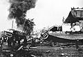
Because Kamaishi was an important city for making iron, it played a big role in Japan's efforts during World War II. The city was targeted by the U.S. Navy. On July 14, 1945, American battleships and cruisers attacked the Japan Ironworks and other important buildings. This was the first time the Japanese mainland was attacked by naval ships. British ships also joined a second attack on August 9. The attacks caused a lot of damage to the city's industrial areas.
Kamaishi After World War II
After the war, Kamaishi helped Japan rebuild and grow. It continued to be known as a "steel town." However, in 1988, the steel mills closed down. This caused a big problem for the city's economy, and almost half of its population moved away. Today, Kamaishi is known more for commercial fishing than for heavy industry.
The 2011 Tōhoku Earthquake and Tsunami
Kamaishi was severely damaged by the powerful 2011 Tōhoku earthquake and tsunami. About 1,250 people in the city were killed or went missing. Many buildings were destroyed, and several schools and evacuation sites were flooded.
A very large breakwater, a wall built to protect the coast from waves, had been finished in 2009. It was 1,950 meters (6,400 feet) long and 63 meters (207 feet) deep. It was even in the Guinness World Records as the world's deepest breakwater. However, the tsunami waves in 2011 were as tall as 14 meters (46 feet) and went right over this huge wall. After the disaster, there was a discussion about whether to rebuild the breakwater, as some people thought it was too expensive and might not work again.
Kamaishi's Economy
In modern times, Kamaishi was famous for making steel. But after the main steel factory closed in 1989, the local economy faced big challenges. Now, the city is working hard to promote eco-tourism, which is travel that helps the environment.
In 2015, the Hashino iron mining and smelting site in Kamaishi became a UNESCO World Heritage Site. This means it's a very important place for history and culture. Commercial fishing and producing shellfish are also very important for Kamaishi's economy today.
Education in Kamaishi
Kamaishi has nine public elementary schools and five public junior high schools. These are run by the city's education board. The Iwate Prefectural Board of Education runs three public high schools. There is also one special education school for students with disabilities.
Sports in Kamaishi
Kamaishi was once home to one of Japan's most successful rugby union clubs, called Nippon Steel Kamaishi. They won many national titles in the 1970s and 1980s. Today, the team is called the Kamaishi Seawaves.
As part of the city's recovery after the 2011 tsunami, Kamaishi hosted some games for the 2019 Rugby World Cup. A new stadium, the Kamaishi Recovery Memorial Stadium, was built for this event. Kamaishi even won an "Award for Character" at the Rugby World Cup 2019 awards for its spirit.
The city also has a semi-professional soccer team, Nippon Steel Corp. Kamaishi S.C.. They play in the 5th division of the Tohoku Soccer League.
Getting Around Kamaishi
Trains
![]() East Japan Railway Company (JR East) - Kamaishi Line
East Japan Railway Company (JR East) - Kamaishi Line
- Rikuchū-Ōhashi - Dōsen - Matsukura - Kosano - Kamaishi
Sanriku Railway – Rias Line
- Tōni - Heita - Kamaishi
Highways
 Sanriku Expressway
 Kamaishi Expressway
 National Route 45
 National Route 283
Port
- Port of Kamaishi
Fun Places to Visit in Kamaishi
- Hashino iron mining and smelting site: This is a UNESCO World Heritage Site where you can learn about the history of iron making.
- Sanriku Fukkō National Park: A beautiful national park with amazing coastal views.
International Connections
Kamaishi has a special friendship with Digne-les-Bains, a town in France. They became sister cities on April 20, 1994.
Famous People from Kamaishi
- Toshiya Miura, a professional soccer manager
- Makoto Sawaguchi, a professional basketball player
- Yu Suzuki, a video game creator
- Katsuhiko Takahashi, a writer
Images for kids
-
A devastating earthquake and tsunami affected Kamaishi in March 1933
See also
 In Spanish: Kamaishi para niños
