1867 Virgin Islands earthquake and tsunami facts for kids

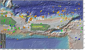
Map of earthquakes around Puerto Rico. The epicenter of the 1867 earthquake is marked in a star located on the right.
|
|
| UTC time | 1867-11-18 18:45:00 |
|---|---|
| 1868-03-17 11:15:00 | |
| USGS-ANSS | ComCat |
| ComCat | |
| Local date | 18 November 1867 |
| Local time | 14:45 |
| Magnitude | 7.5 Ms |
| Epicenter | 18°12′N 65°00′W / 18.2°N 65.0°W |
| Areas affected | Greater Antilles & Lesser Antilles |
| Total damage | Extensive |
| Max. intensity | IX (Devastating Tremor) |
| Tsunami | 18.3 m (60 ft) |
| Landslides | Possible |
| Aftershocks | 6.5 Mw |
| Casualties | >50–"hundreds" dead |
The 1867 Virgin Islands earthquake and tsunami was a powerful natural disaster. It happened on November 18, 1867, at 2:45 p.m. The earthquake struck near Saint Thomas, which was then part of the Danish West Indies. This area is now known as the U.S. Virgin Islands.
The earthquake had a magnitude of 7.5. It occurred just 20 days after a huge storm, the San Narciso Hurricane, hit the same region. The earthquake caused some of the biggest tsunamis ever recorded in the Lesser Antilles islands. Waves reached over 10 meters (about 33 feet) high in some places. While the exact number is debated, at least 50 people lost their lives, and some reports suggest hundreds of deaths.
What Caused the Earthquake?
The U.S. Virgin Islands are located in a very active part of the Earth. This area is where the North American Plate is slowly sliding underneath the Caribbean Plate. Think of it like two giant puzzle pieces of the Earth's crust pushing against each other. This process is called subduction.
Because of this movement, the ground can stretch and break, creating faults. Both the deep subduction zone and shallower faults can cause earthquakes. These earthquakes can also trigger tsunamis, which are giant ocean waves.
The Ground Shakes
The 1867 earthquake actually happened in two main parts, called "shocks." These two shocks occurred about 10 minutes apart. After each shock, a tsunami wave followed about 10 minutes later.
In Frederiksted, people said the shaking lasted for a whole minute. It was so strong that it kicked up a huge cloud of dust, covering the town. The shaking was rated as "Devastating Tremor" on the Rossi–Forel scale, which is a way to measure how strong an earthquake feels. This intense shaking was felt across the Danish West Indies, British Virgin Islands, Puerto Rico, and the U.S. Virgin Islands.
Some people who lived through it said they felt two very clear shakes, about 10 to 15 minutes apart. On another scale, the Modified Mercalli intensity scale, the shaking ranged from "Severe" to "Extreme."
The Giant Waves (Tsunami)
The tsunami was a major part of this disaster. At Saint Thomas, the first wave was described as a "straight white wall" of water, about 4.6 to 7 meters (15 to 23 feet) high. This massive wave rushed into the harbor about 10 minutes after the earthquake. It picked up large ships and carried them along. The wave reached up to 9.1 meters (30 feet) high across the town. A smaller wave followed soon after, pushing even further inland. Sadly, 30 people died in Saint Thomas when the waves swept them away.
In Charlotte Amalie, waves reached 6 meters (20 feet), and 12 people lost their lives. A steamship called the La Plata was swamped by the tsunami, and almost everyone on board died.
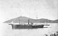
Little Saba island saw the highest waves, reaching an incredible 15.2 meters (50 feet). A US Navy ship, the USS De Soto, had just arrived the day before. The first wave ripped it from its anchors and pushed it onto the land. Then, the second wave pulled the ship back out to sea, but its bottom was badly damaged.
At Christiansted on Saint Croix island, waves between 7 and 9 meters (23-30 feet) high drowned five people. The water flooded the island up to 90 meters (295 feet) inland. The tsunami destroyed 20 houses and left many boats stranded far from the water. In some parts of the island, waves reached 14.6 meters (48 feet). Frederiksted, also on Saint Croix, was hit by waves up to 7.6 meters (25 feet). Another US Navy ship, the USS Monongahela, was pushed onto the beaches there. On Water Island, the tsunami waves were 12 meters (39 feet) high.
In the British Virgin Islands, at Road Town, the waves were smaller, about 1.2 to 1.5 meters (4-5 feet). Still, they swept away much of the low-lying parts of the town. In Antigua, the sea level rose 2.4 to 3.0 meters (8-10 feet) at Saint John harbor.
Eyewitnesses in Basse-Terre, Guadeloupe, saw the sea pull back and then rush in, flooding the area up to 2 meters (6.5 feet) deep. Deshayes was hit by very high waves, estimated at 18.3 meters (60 feet) tall and stretching for 5 kilometers (3 miles). These waves carried away many personal items. However, in Saint-Rose, the waves were no more than 10 meters (33 feet) high. A church located 10 meters above sea level, where people had gone for safety, remained undamaged.
In Puerto Rico, waves between 1 and 6 meters (3-20 feet) swept across the island's coast. A church in Bayamón was damaged by the earthquake's shaking.
 | William Lucy |
 | Charles Hayes |
 | Cleveland Robinson |


