
2016 Kaikōura earthquake facts for kids

|
|
| UTC time | 2016-11-13 11:02:56 |
|---|---|
| ISC event | 615035032 |
| USGS-ANSS | ComCat |
| Local date | 14 November 2016 |
| Local time | 00:02:56 NZDT |
| Duration | ~ 2 minutes |
| Magnitude | 7.8 Mw |
| Depth | 15 km (9 miles) |
| Epicenter | 42°45′25″S 173°04′37″E / 42.757°S 173.077°E 15 km (9 miles) north-east of Culverden |
| Type | Oblique-slip |
| Areas affected | New Zealand |
| Max. intensity | IX (Violent) |
| Peak acceleration | 3.2 g |
| Tsunami | Yes |
| Landslides | Yes |
| Aftershocks | > 20,200 (as of 22 November 2017) |
| Casualties | 2 dead 57 treated for injuries |


The 2016 Kaikoura earthquake was a very strong earthquake that hit the South Island of New Zealand. It happened just after midnight on November 14, 2016. This earthquake was special because it broke many different faults (cracks in the Earth's crust) at the same time. Scientists have called it the "most complex earthquake ever studied."
The earthquake started about 15 kilometers (9 miles) northeast of Culverden. This is about 60 kilometers (37 miles) southwest of the popular town of Kaikōura. The shaking began about 15 kilometers (9 miles) deep inside the Earth. The whole event, with different faults breaking, lasted for about two minutes. The total strength of the earthquake was measured at 7.8 on the Moment magnitude scale. Sadly, two people died, and the earthquake caused over $1.8 billion in damage.
Contents
What Happened During the Earthquake?

The main earthquake started at 12:02:56 AM on November 14, 2016, and lasted for about two minutes. The spot deep underground where the earthquake began is called the hypocentre. It was 15 kilometers (9 miles) deep. The epicentre, which is the spot on the surface directly above the hypocentre, was 15 kilometers (9 miles) northeast of Culverden.
From where it started, the breaks in the Earth's crust (called ruptures) quickly spread northwards. They moved at a speed of 2 kilometers (1.2 miles) per second. The ruptures traveled over a distance of up to 200 kilometers (124 miles). The strongest shaking and most energy were released about 100 kilometers (62 miles) north of the epicentre, near Seddon.
At first, experts thought about six faults had broken. But later, detailed studies showed that an amazing 25 different faults had ruptured! This is believed to be a world record for the most faults breaking in one earthquake. Because of how complicated it was, scientists are now rethinking some of their ideas about how earthquakes work.
How the Land Moved
The earthquake caused big changes to the land. For example, the Kekerengu Fault moved by as much as 10 meters (33 feet) in some places. A new fault was even found in Waipapa Bay.
Cape Campbell, at the very top of the South Island, moved more than 2 meters (6.6 feet) closer to the North Island. It also rose almost 1 meter (3.3 feet) higher. Kaikōura itself moved nearly 1 meter (3.3 feet) northeast and rose 70 centimeters (2.3 feet). Even the North Island moved a little, with the Wellington area shifting a few centimeters north.
Tsunami After the Earthquake
A tsunami is a series of very large ocean waves. A tsunami followed the Kaikōura earthquake. It reached a peak height of about 7 meters (23 feet) in some places. The highest wave was recorded at Goose Bay. At Oaro, the wave was about 5.3 meters (17 feet) high.
After the tsunami, sea creatures and plants were found scattered far inland. They were found up to 250 meters (820 feet) from the normal high tide line on the Oaro River flood plain.
Right after the earthquake, the water level at the Kaikōura tide gauge dropped quickly. It fell about 2.5 meters (8.2 feet) in 25 minutes. This sudden drop is a classic warning sign that a tsunami is coming. Then, the water level rose by about 4 meters (13 feet) in the next 15 minutes. Many more waves followed over several hours.
The Kaikōura tide gauge itself rose about 1 meter (3.3 feet) because the land under it lifted. So, the water level measured at the gauge was 2.5 meters (8.2 feet) higher than it would have been normally. Other places like Wellington Harbour and Christchurch also recorded the tsunami.
A tsunami estimated at 5 meters (16 feet) high hit Little Pigeon Bay on Banks Peninsula. It pushed an empty holiday house off its foundations, causing a lot of damage.
Impact and Damage
Kaikōura and Nearby Areas
Two people sadly died because of the earthquake. One man died when his historic home near Kaikōura collapsed. Another woman died in a damaged log house in Mount Lyford.
Many main roads in the South Island had to close. This was due to landslides and damaged bridges. State Highway 1 between Picton and Waipara was closed. Also, the road between Waipara and Springs Junction was affected. Most roads reopened within a day. However, the main roads into Kaikōura stayed closed for much longer. This included State Highway 1 and the Inland Kaikoura Road. The railway line was also cut off. This meant Kaikōura was completely isolated by land.
It took months to repair State Highway 1. The railway line, which is important for moving goods, took over a year to fix. The roads that were used as detours saw much more traffic than usual.
Water supply was mostly back in Kaikōura by November 19. But the sewage system was badly damaged and couldn't be used. The Inland Kaikoura Road eventually reopened to people with permits on November 30, 2016. It fully reopened to all traffic on December 19, 2016. State Highway 1 south of Kaikōura reopened two days later. However, the section north of Kaikōura took over a year to repair, finally opening on December 15, 2017.
The railway line from Picton to Christchurch was fully restored by September 15, 2017. But passenger trains did not start running again until December 1, 2018.
Effects on Nature
The earthquake lifted the coast at Kaikōura by up to 6 meters (20 feet). This exposed the intertidal zone, which is the area between high and low tide. Many sea creatures and plants, like Durvillaea bull kelp, died because they were suddenly out of the water. This greatly changed the natural balance of the coastal area.
The Hutton's shearwater bird colony in the Seaward Kaikoura ranges was also badly damaged. Large landslides buried up to 20% of the areas where these birds lived. The shaking also damaged their burrows. Many birds were laying eggs when the earthquake hit, so there were likely many losses.
Damage in Wellington
In the city of Wellington, many buildings were damaged. Some were so badly hurt they had to be pulled down. Damage to the docks briefly stopped ferry services across Cook Strait. Container shipping, which moves goods, did not restart for over ten months.
A nine-story office building on Molesworth Street was so damaged it had to be demolished in December 2016. A parking building near Courtenay Place was also pulled down. These building failures caused nearby streets to be closed for a while.
By February 2017, business insurance claims for damage had reached over NZ$900 million. Most of this damage was in the Wellington region. Several buildings that were built only in the last ten years failed. This was because of problems with their design or internal systems.
Christchurch and Other Areas
In the coastal suburb of New Brighton in Christchurch, some houses were robbed. This happened after people left their homes because of the tsunami warning.
Schools and universities across the affected region were closed. This affected the end-of-year NCEA exams for high school students. Exams on the day of the earthquake were canceled in many schools. Students received special "derived grades" for any exams they were supposed to take that week.
Aftershocks
-
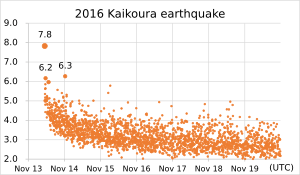
Magnitude of Kaikōura earthquakes
-
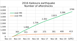
Number of aftershocks within 200 km of Kaikōura


After the main earthquake, there were many smaller earthquakes called aftershocks. More than 20,200 aftershocks were recorded by November 2017. Some of these aftershocks were quite strong themselves. The table below shows some of the larger aftershocks (magnitude 5.0 or higher).
| Aftershocks 5.0 Magnitude or Higher | |||||
|---|---|---|---|---|---|
| Date | Time (NZDT) | Magnitude | Depth | Epicentre | Ref |
| 14 November 2016 | 00:02:56 | 7.8 | 15 km (9 mi) | 15 km northeast of Culverden | |
| 14 November 2016 | 00:16:10 | 5.6 | 2 km (1 mi) | 5 km west of Culverden | |
| 14 November 2016 | 00:19:32 | 5.9 | 12 km (7 mi) | 45 km north of Kaikōura | |
| 14 November 2016 | 00:24:17 | 5.6 | 12 km (7 mi) | 40 km north of Kaikōura | |
| 14 November 2016 | 00:30:25 | 5.0 | 15 km (9 mi) | 30 km north of Cheviot | |
| 14 November 2016 | 00:32:06 | 6.2 | 29 km (18 mi) | 15 km north of Kaikōura | |
| 14 November 2016 | 00:33:49 | 5.5 | 6 km (4 mi) | 25 km southeast of Seddon | |
| 14 November 2016 | 00:41:48 | 5.6 | 9 km (6 mi) | 20 km southeast of Seddon | |
| 14 November 2016 | 00:52:44 | 6.2 | 32 km (20 mi) | 25 km north of Kaikōura | |
| 14 November 2016 | 01:03:53 | 5.2 | 9 km (6 mi) | 15 km southeast of Seddon | |
| 14 November 2016 | 01:04:21 | 5.3 | 10 km (6 mi) | 15 km southeast of Wellington | |
| 14 November 2016 | 01:20:41 | 5.0 | 30 km (19 mi) | 25 km northeast of Kaikōura | |
| 14 November 2016 | 01:25:55 | 5.2 | 30 km (19 mi) | 10 km north of Culverden | |
| 14 November 2016 | 01:27:59 | 5.2 | 30 km (19 mi) | 10 km northeast of Kaikōura | |
| 14 November 2016 | 01:37:43 | 5.2 | 15 km (9 mi) | 25 km west of Kaikōura | |
| 14 November 2016 | 01:38:38 | 5.3 | 7 km (4 mi) | 15 km east of Seddon | |
| 14 November 2016 | 01:52:18 | 5.1 | 17 km (11 mi) | 15 km northeast of Kaikōura | |
| 14 November 2016 | 02:21:11 | 5.7 | 0 km (0 mi) | 25 km southeast of Seddon | |
| 14 November 2016 | 02:31:26 | 6.0 | 25 km (16 mi) | 15 km north of Kaikōura | |
| 14 November 2016 | 02:50:01 | 5.1 | 8 km (5 mi) | 20 km southeast of Seddon | |
| 14 November 2016 | 03:04:04 | 5.1 | 38 km (24 mi) | 35 km north of Cheviot | |
| 14 November 2016 | 04:33:03 | 5.3 | 16 km (10 mi) | 20 km southeast of Seddon | |
| 14 November 2016 | 06:17:39 | 5.1 | 9 km (6 mi) | Within 5 km of Kaikōura | |
| 14 November 2016 | 07:34:26 | 5.2 | 23 km (14 mi) | 20 km southeast of Seddon | |
| 14 November 2016 | 07:58:45 | 5.4 | 19 km (12 mi) | 15 km southeast of Seddon | |
| 14 November 2016 | 07:59:10 | 5.2 | 51 km (32 mi) | 20 km northeast of Kaikōura | |
| 14 November 2016 | 08:09:14 | 5.0 | 17 km (11 mi) | 10 km southeast of Seddon | |
| 14 November 2016 | 08:28:44 | 5.1 | 8 km (5 mi) | 25 km east of Seddon | |
| 14 November 2016 | 09:21:27 | 5.0 | 14 km (9 mi) | 25 km east of Seddon | |
| 14 November 2016 | 09:22:14 | 5.0 | 27 km (17 mi) | 15 km northeast of Kaikōura | |
| 14 November 2016 | 09:51:21 | 5.1 | 82 km (51 mi) | 40 km northeast of Hanmer Springs | |
| 14 November 2016 | 11:19:32 | 5.4 | 45 km (28 mi) | 35 km east of Hanmer Springs | |
| 14 November 2016 | 12:17:32 | 5.2 | 27 km (17 mi) | 35 km northeast of Kaikōura | |
| 14 November 2016 | 12:49:11 | 5.2 | 13 km (8 mi) | 25 km east of Seddon | |
| 14 November 2016 | 12:54:43 | 5.0 | 22 km (14 mi) | 30 km southwest of Kaikōura | |
| 14 November 2016 | 13:33:51 | 5.7 | 16 km (10 mi) | 30 km southwest of Kaikōura | |
| 14 November 2016 | 13:34:22 | 6.3 | 35 km (22 mi) | 30 km southwest of Kaikōura | |
| 14 November 2016 | 14:28:22 | 5.5 | 35 km (22 mi) | 30 km southwest of Kaikōura | |
| 14 November 2016 | 14:30:14 | 5.3 | 45 km (28 mi) | 30 km southwest of Kaikōura | |
| 14 November 2016 | 18:16:31 | 5.0 | 55 km (34 mi) | 30 km southwest of Kaikōura | |
| 14 November 2016 | 19:43:00 | 5.6 | 23 km (14 mi) | 30 km southwest of Kaikōura | |
| 14 November 2016 | 19:47:52 | 5.7 | 53 km (33 mi) | 30 km southwest of Kaikōura | |
| 14 November 2016 | 20:21:04 | 5.8 | 23 km (14 mi) | 30 km southwest of Kaikōura | |
| 14 November 2016 | 22:49:56 | 5.0 | 8 km (5 mi) | 30 km southwest of Kaikōura | |
| 15 November 2016 | 00:16:42 | 5.1 | 25 km (16 mi) | 15 km east of Seddon | |
| 15 November 2016 | 08:17:33 | 5.0 | 19 km (12 mi) | 15 km north of Kaikōura | |
| 15 November 2016 | 14:34:45 | 5.8 | 4 km (2 mi) | 15 km east of Seddon | |
| 15 November 2016 | 14:43:52 | 5.2 | 12 km (7 mi) | 15 km east of Seddon | |
| 15 November 2016 | 18:09:27 | 5.4 | 7 km (4 mi) | 15 km northwest of Kaikōura | |
| 15 November 2016 | 19:30:33 | 5.8 | 7 km (4 mi) | 20 north of Kaikoura | |
| 17 November 2016 | 10:05:00 | 5.0 | 22 km (14 mi) | 10 km southeast of Seddon | |
| 19 November 2016 | 03:22:58 | 5.0 | 21 km (13 mi) | 20 km northeast of Cheviot | |
| 20 November 2016 | 19:52:48 | 5.0 | 21 km (13 mi) | 25 km southwest of Kaikōura | |
| 22 November 2016 | 18:13:34 | 5.7 | 21 km (13 mi) | 15 km southeast of Culverden | |
| 4 December 2016 | 16:15:47 | 5.5 | 12 km (7 mi) | 10 km east of Seddon | |
| 29 December 2016 | 15:34:33 | 5.5 | 15 km (9 mi) | 35 km east of Seddon | |
| 6 January 2017 | 00:17:33 | 5.3 | 13 km (8 mi) | 20 km southwest of Seddon | |
| 11 January 2017 | 13:19:22 | 5.1 | 11 km (7 mi) | 15 km east of Seddon | |
| 1 February 2017 | 23:21:29 | 5.1 | 16 km (10 mi) | 10 km northeast of Kaikōura | |
| 12 February 2017 | 09:18:54 | 5.2 | 9 km (6 mi) | 15 km northwest of Culverden | |
| 2 March 2017 | 08:01:02 | 5.2 | 12 km (7 mi) | 20 km southwest of Cheviot | |
| 20 September 2017 | 14:42:10 | 5.1 | 15 km (9 mi) | 30 km northeast of Seddon | |
| 22 October 2017 | 17:10:59 | 5.6 | 8 km (5 mi) | 10 km west of Kaikōura | |
Gallery
-
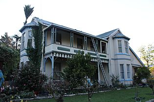
The Elms homestead, pictured here in 2012, collapsed during the earthquake, killing one person.
-
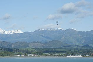
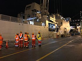
Supplies being delivered by helicopter from the USS Sampson.
-
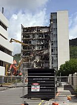
Demolition of a damaged building on Molesworth Street, Wellington.
-
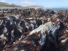
The earthquake lifted the coast, causing many sea organisms like Durvillaea kelp to die.
-
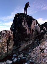
Measuring the uplifted land in the intertidal zone at Kaikōura.
-
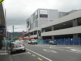
Demolition of the damaged cinema and parking building at Queensgate Shopping Centre, Lower Hutt.
-
Baggage of people evacuated from Kaikōura being unloaded from HMNZS Canterbury.

.jpg)


Images for kids
-
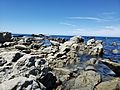
Uplifted shoreline on the Kaikōura Peninsula in 2020.
-
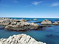
Uplifted shoreline at Ward Beach in 2020.


See also
 In Spanish: Terremoto de North Canterbury de 2016 para niños
