2020 China–India skirmishes facts for kids
Quick facts for kids China–India skirmishes |
|||||||
|---|---|---|---|---|---|---|---|
| Part of the Sino-Indian border dispute | |||||||
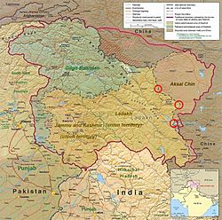
 A CIA map of Kashmir with red circles marking the rough locations. |
|||||||
|
|||||||
| Belligerents | |||||||
| Commanders and leaders | |||||||
|
(Prime Minister of India) |
(CCP General Secretary & CMC Chairman) (CMC Vice Chairman) (CMC Vice Chairman) |
||||||
| Units involved | |||||||
|
|
||||||
| Casualties and losses | |||||||
| 20 killed | Unknown | ||||||
The 2020 China–India skirmishes are part of an ongoing military disagreement between China and India. Since May 5, 2020, soldiers from both countries have been involved in clashes. These events have happened in different places along the Sino-Indian border.
Contents
What Are the China-India Skirmishes?
These skirmishes are small military clashes. They are part of a bigger, long-standing argument about the border between China and India. Both countries have troops stationed along this border.
Why Are These Clashes Happening?
The main reason for these clashes is that the border between China and India is not clearly marked everywhere. This unclear border is called the Line of Actual Control (LAC). It was set up after a war between the two countries in 1962.
Another reason is that both countries are building new roads and other structures near the border. This can sometimes lead to their soldiers meeting in areas where the border is not agreed upon.
Where Have the Clashes Taken Place?
The clashes have happened in a few key areas:
- Near the Pangong Lake in Ladakh.
- At the Nathu La pass in Sikkim.
- Other spots in eastern Ladakh along the LAC.
The Galwan Valley Incident
One serious clash happened on June 16, 2020. This was a hand-to-hand fight in the Galwan Valley. Sadly, 20 Indian soldiers, including an officer, died. Indian news sources reported that at least 43 Chinese soldiers were also killed or hurt. US intelligence sources believed about 35 Chinese soldiers died.
What Happened After the Clashes?
Some reports suggested that China took control of about 60 square kilometers of land that India used to patrol. However, China has said that it did not take any territory. Both countries agreed to pull back their troops by June 2020 to reduce tension.
India's External Affairs Minister, S Jaishankar, stated that the ongoing military standoff is because China has not followed earlier agreements.
Images for kids
-
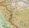
A 1947 map of Republic of China. All the clashes of the 2020–21 skirmishes have taken place outside these boundaries in Indian territory.
-
Fingers 1 to 8 visible on the north bank of Pangong Tso. On the south bank is Gurung Hill with features Helmet, Black Top, Table Top, Camel's Top. Chushul, Chushul/Maldo BPM point and airstrip, Magar Hill, Rechin La, Rezang La, Rezangla War Memorial, Spanggur Gap and Spanggur Tso, visible. Chinese and Indian claim lines (updated to 1992) marked.
-
The site of Galwan clash at the river bend. Also seen are the LAC claimed by China June 2020 in green, and the prevailing LAC marked by the US Office of the Geographer in red
See also
 In Spanish: Escaramuzas entre China e India en 2020 para niños
 | DeHart Hubbard |
 | Wilma Rudolph |
 | Jesse Owens |
 | Jackie Joyner-Kersee |
 | Major Taylor |


