
2023 Hawaii wildfires facts for kids
Quick facts for kids 2023 Hawaii wildfires |
|
|---|---|
|
From top, left to right: Satellite image of Maui • Lāhainā Banyan Court Park • Front Street • Lāhainā Harbor
|
|
| Location | Hawaiʻi, United States |
| Statistics | |
| Total fires | 4+ |
| Total area | 17,000+ acres (6,880+ ha) |
| Cost | ~$5.52 billion (as of August 11) |
| Date(s) | August 8, 2023 – present |
| Cause | Unknown |
| Buildings destroyed | 2,207 |
| Deaths | 115+ (99% of the Lahaina area searched) |
| Non-fatal injuries | 67+ |
| Missing people | 110 |


In August 2023, many wildfires started in Hawaii, mostly on the island of Maui. Strong winds made the fires spread quickly. These fires forced many people to leave their homes. They caused a lot of damage and sadly, at least 115 people died. About 110 people were also reported missing in the town of Lahaina, Hawaii.
The fires spread fast because of dry, windy weather. This weather was caused by a strong high-pressure system north of Hawaii and Hurricane Dora to the south.
On August 8, the governor of Hawaii declared an emergency. This allowed the Hawaii National Guard to help. It also allowed state money to be used for relief. By August 9, the whole state of Hawaii was under a state of emergency. On August 10, U.S. President Joe Biden also declared a major disaster.
In Lahaina alone, over 2,200 buildings were destroyed. Most of these were homes. Many important historic places in Lahaina were also lost. The damage from the fire is estimated to be almost $6 billion.
Contents
Why the Fires Happened
Wildfire Dangers in Hawaii

The amount of land burned by wildfires in Hawaii has grown a lot in recent years. It has almost quadrupled. Experts say this is because of two main reasons. First, non-native plants are spreading. These plants can burn easily. Second, the weather is getting hotter and drier due to climate change.
Experts had warned that large areas of land were not being managed. This was happening because farming in Hawaii had decreased. Invasive plants like guinea grass were growing fast. These plants made the risk of big wildfires much higher. The state government did not make rules for landowners to keep their land clear. This is a common rule in places like California, which also has many fires.
Also, fewer farm workers meant fewer people to help fight fires. These workers used to help put out fires on the land they cared for.
Around the time of the fires, parts of Maui were very dry. Twenty percent of Maui County had moderate drought. Sixteen percent had severe drought. Rainfall in Hawaii has also decreased. This matches what scientists expect from climate change. Water problems also made the drought worse. This meant less water was available to fight the fires.
In 2014, a group warned that most of Lahaina was at a very high risk for wildfires. In 2020, Maui County also said that Lahaina was in a high-risk zone for fires.
In August 2023, experts predicted a higher chance of big wildfires for Hawaii. They noted that a lot of plants had grown during the wet season. They also saw the drought getting worse. They mentioned that tropical cyclones could bring strong winds and dry conditions. This could make fires grow faster.
Before these fires, the danger of deadly wildfires in Hawaii was underestimated. A 2022 report said wildfires were one of the lowest threats for the state. A 2021 Maui County report noted the rise in wildfires. But it said there wasn't enough money to prevent them. It also criticized the fire department's plan for not focusing on fire prevention.
Weather Conditions

In early August 2023, a high-pressure system stayed north of the Hawaiian Islands. This created strong winds. At the same time, Hurricane Dora became a very strong Category 4 hurricane. This hurricane was far from Hawaii. But it may have helped create a big difference in air pressure. This pressure difference made the trade winds even stronger over the islands.
By August 6, very dry air arrived from the East Pacific. This meant almost no rain would fall. Strong winds and very dry conditions continued from August 7 to 8. As the day went on, the winds became even stronger. Humidity levels were much lower than normal. These conditions made it easy for fires to start and spread.
List of Wildfires
| Name | Acres Burned | Start Date | Containment Status | Date of Containment |
|---|---|---|---|---|
| Olinda | 1,081 | August 8 |
90%
|
September 7 |
| Kula | 202 | August 8 |
95%
|
September 7 |
| Lahaina | 2,170 | August 8 | Fully contained | September 3 |
| Pulehu | 3,268 | August 8 | Fully contained | August 12 |
Impact of the Fires

Hawaii's governor, Josh Green, called the Lahaina wildfires the "worst natural disaster" in Hawaii's history. It is the fifth deadliest wildfire in U.S. history. It is also the deadliest U.S. wildfire since the Cloquet fire in 1918.
People Affected
As of September 4, 2023, 115 deaths were confirmed from the Lahaina fire. Also, 110 people were still missing.
Damage to Buildings and History


The main Maui wildfire destroyed much of Lahaina. Over 2,200 buildings were damaged or ruined. Most of these (96%) were homes. Many historic places in the downtown Lahaina Historic District were also lost. The fire was so hot, reaching 1,000 °F (538 °C), that it melted granite counters and engine parts. Melted aluminum was seen under burned cars.
The total damage was first estimated at $5.52 billion. However, some experts believe that many homes in Lahaina were not insured. Or they did not have enough insurance. This means many owners might not have enough money to rebuild. Many Native Hawaiians could afford to live in Lahaina because they inherited their homes. They did not need loans, so they were not required to have homeowners insurance.
The Lahaina Historic District was a National Historic Landmark. It was also the capital of the Kingdom of Hawaii for 35 years. This area was badly damaged. Many important buildings were destroyed:
- The Waiola Church lost its main church and other buildings. This church was founded in 1823. Its cemetery is where members of the Hawaiian Royal Family are buried.
- The Lahaina Jodo Mission, a Buddhist temple, was destroyed. It had been in its current spot since 1932.
- The Pioneer Inn, a famous hotel built in 1901, was lost.
- The Nā ʻAikāne Cultural Center, a local cultural center, was also destroyed.
- The Old Lahaina Courthouse was badly damaged. Its roof was completely destroyed. The Lahaina Heritage Museum, inside the courthouse, and its collection were also lost. Luckily, copies of the museum's documents were saved online.
- The Baldwin Home Museum, built in 1834, burned down. It was the oldest house on Maui. Important items like medical tools and family furniture were lost.
- The Wo Hing Society Hall, built in the early 1900s, was also destroyed. It had been restored as the Wo Hing Museum.
The fires also damaged cell towers. This caused phone service outages. It also made 9-1-1 emergency services unavailable in some areas. The fire near Kula also destroyed at least two homes.
The Maria Lanakila Catholic Church in Lahaina was not destroyed. Its main building and steeple survived. However, the roof and inside may have some damage.
The Lahaina Civic Center was used as an evacuation center. It has not been badly damaged. It is the place for the Maui Invitational Tournament, a college basketball event. It is not yet known if the 2023 tournament will still be held there.
Environment and Water

Lahaina's famous banyan tree is the largest in the United States. Most of its leaves were burned. But the tree itself was still standing. People watered the tree to help it recover. Some green leaves have started to grow back. The roots, trunk, and branches were mostly okay.
After the fires, warnings were given about unsafe water. Residents in Lahaina and Upper Kula were told not to drink or use tap water. Even boiling the water would not make it safe. Water tankers were set up to provide clean drinking water.
Scientists are also worried about the environment. Burned soil and toxic debris could wash into the ocean. This could harm marine life and coral reefs.
Evacuations and Travel
The fires caused thousands of people to leave their homes. Residents and visitors from Lāhaina, Kāʻanapali, Kīhei, and Kula had to evacuate. The U.S. Coast Guard rescued 17 people who jumped into the sea to escape the fires. By August 12, over 1,400 people were staying in shelters on Maui.
About 11,000 people flew out of Maui on August 9. Airlines added more flights to help people leave the island. They also removed fees for changing or canceling flights.
Hawaii state officials planned to house visitors and displaced residents at the Hawaii Convention Center in Honolulu.
After the fire, Maui County blocked roads into West Maui. This made it hard for people to get medicine, food, and fuel. It also stopped people from getting their belongings. The county later reopened one checkpoint to help. But it was closed again because people tried to enter the sealed-off areas of Lahaina.
Wildlife and Pets
The Maui Humane Society said about 3,000 animals from Lahaina were missing after the fires. They received many reports of lost animals. They also created a "Missing Pets of Maui" Facebook page. Found animals are checked for identification. The society asked people not to move or destroy deceased animals. This helps them identify them.
Animal welfare groups and police searched burned areas for animals. They set up feeding and drinking stations. Over 100 shelter animals were flown to Portland, Oregon. This made room for animals affected by the fires. Vets and volunteers gave free medical care, food, and medicine to animals. They also helped police K-9 units working in the recovery efforts.
Scientists are preparing to study water quality changes. They want to see how soil erosion from the fire affects waterways and ecosystems. People were also thankful that the Maui Bird Conservation Center was safe. It houses many alalā birds.
Images for kids
-
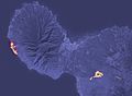
Maui as seen from infrared satellite the night of August 8
-
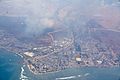
Lahaina from above
-
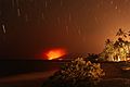
A long-exposure photograph of Lahaina on the night of August 8 to 9 from South Maui — the curved streaks are star trails, not embers
-
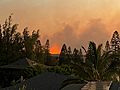
August 8 fire above Kīhei, HI


See also
 In Spanish: Incendios forestales en Hawái de 2023 para niños
- 2023 Canadian wildfires
- 2023 Greece wildfires
- List of wildfires in the United States
- Wildfires in the United States
