2023 Iceland earthquakes facts for kids
| UTC time | 2023-11-10 18:00:56 |
|---|---|
| USGS-ANSS | ComCat |
| Local date | 24 October 2023 (23 days) |
| Magnitude | 5.3 Mw (largest tremor) |
| Depth | 2–10 km (1.2–6.2 mi) |
| Epicenter | 63°51′00″N 22°34′44″W / 63.850°N 22.579°W |
| Areas affected | Reykjanes Peninsula, Iceland |
| Max. intensity | VIII (Severe) |
| Casualties | None |
| 2023 Sundhnúkur eruption | |
|---|---|
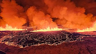
The 2023 eruption taken by the Icelandic Meteorological Office on 18 December 2023
|
|
| Volcano | Svartsengi |
| Type | Fissure eruption |
| Location | Reykjanes Peninsula, Iceland 63°52′44″N 22°23′13″W / 63.879°N 22.387°W |
| Impact | Earthquakes, ground subsidence, lava fountains, lava flows; town of Grindavik heavily damaged and evacuated |
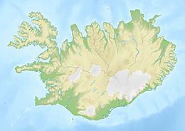
In late 2023, the Reykjanes Peninsula in Iceland experienced many earthquakes. This "earthquake swarm" started on October 24, 2023. It happened because hot, melted rock (called magma) was moving underground.
The number and strength of these earthquakes grew a lot by November 10. More than 20,000 tremors were felt. The strongest one was a magnitude 5.3 earthquake. Because of the danger, the town of Grindavík had to be evacuated. This town is very close to where the earthquakes were happening. The ground in and around Grindavík also sank, causing a lot of damage.
Then, on December 18, 2023, a volcano erupted near Sundhnúkur, just north of Grindavík.
Contents
Why Iceland Has Earthquakes
Iceland is a very active place for earthquakes and volcanoes. This is because it sits on top of two huge tectonic plates. These plates, the Eurasian and North American plates, are slowly pulling apart. This area is known as the Mid-Atlantic Ridge.
While earthquakes happen often in Iceland, this recent swarm was much bigger than usual. Since 2021, there have been three volcanic eruptions on the Reykjanes Peninsula. These happened near the Fagradalsfjall volcano.
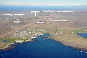
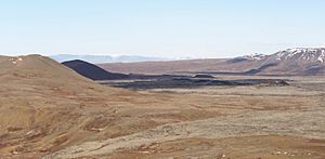
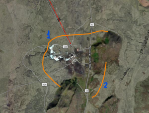
The 2023 earthquake swarm is linked to a long underground magma channel. This channel is about 15 kilometers (9.3 miles) long. It runs under the Sundhnúkur crater chain. The biggest earthquakes started under these craters. Then, they moved southwest, going under Grindavík and out to sea. Grindavík itself is built on old lava from Sundhnúkur, which erupted about 2,350 years ago.
The Earth Shakes: Earthquakes
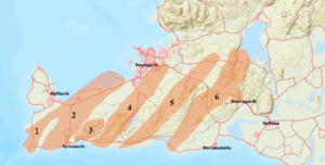
The 2023 earthquakes began almost four years after volcanic activity started near Mount Þorbjörn. This showed that the Reykjanes Peninsula was starting a new period of volcanic activity. The area had been quiet for 800 years. This was the fifth time magma had moved into the Eldvörp-Svartsengi volcanic system since 2019. The earlier magma movements did not lead to eruptions.
October Earthquakes
The earthquake swarm began on the evening of October 24. This was due to magma moving underground. By October 30, the earthquakes became less intense. About 8,000 earthquakes were detected. Most of these tremors happened about 2 to 4 kilometers (1.2 to 2.5 miles) deep. The Icelandic Meteorological Office (IMO) said the swarm was focused near Svartsengi, north of Grindavík. Earlier in October, the area had over 700 earthquakes. The strongest one was a magnitude 3.3.
November Earthquakes
The largest earthquake so far was a magnitude 5.3 on November 10. By this time, over 22,000 earthquakes had been recorded. The IMO thought an eruption was likely. They said it would take days for the magma to reach the surface. The magma was thought to be mostly under the Sundhnúkur crater chain. This is about 3.5 kilometers (2.2 miles) north of Grindavík.
On November 14, scientists found sulphur dioxide gas in the air. This meant magma was only a few hundred meters below the surface. Even though the number of earthquakes went down after November 10, the IMO still recorded 700 to 1,000 earthquakes daily.
Sensors showed that the ground had moved apart by 120 centimeters (47 inches). Satellite measurements showed a large area of land had sunk by about 1 meter (3.3 feet). This area was about 5 kilometers (3.1 miles) long and 2 kilometers (1.2 miles) wide. It ran from the Sundhnúkur craters to the west side of Grindavík. This sinking created a graben-like shape. Scientists estimated that a huge amount of magma had moved underground. The ground continued to sink by about 4 centimeters (1.6 inches) each day.
A large crack opened up through Grindavík. Old maps showed this was an old fault line that had become active again. Scientists at the University of Iceland believe this fault was made by the last Sundhnúkur eruption over 2,000 years ago.
On November 16, sensors found sulphur dioxide in a deep hole near Svartsengi. This is a clear sign of magma being close to the surface. The IMO believed the area around Hagafell mountain, about 2 kilometers (1.2 miles) north of Grindavík, was at the highest risk. From November 18 to 21, the ground in the Svartsengi area quickly rose by 30 millimeters (1.2 inches). This likely meant magma was rising from about 5 kilometers (3.1 miles) deep. An eruption was still expected on November 21. However, as earthquake activity slowed down after November 24, the chance of an eruption also decreased.
Professor Magnús Tumi Guðmundsson, a geophysicist, explained that the magma channel, about two meters wide, quickly became solid. About 90% of the magma hardened within 10 to 15 days. This happened because the Earth's crust is cold. Some magma near Sundhnúkur still poses a risk if underground pressure increases. Magnús noted that while magma cools fast, the surrounding rock stays hot and weak. This keeps the area geologically vulnerable for several months. So, careful monitoring is still needed. If an eruption happens, it will likely be between Sýlingarfell and Hagafell mountains.
The ground around Svartsengi moved a lot. It shifted about 100 centimeters (39 inches) to the west and 25 centimeters (9.8 inches) to the north. When Grindavík was evacuated on November 10, the ground near Svartsengi first sank by 35 centimeters (13.8 inches). Then, it rose by 25 centimeters (9.8 inches). A GPS station east of Grindavík moved 60 centimeters (23.6 inches) east and 40 centimeters (15.7 inches) south. It also moved up by 12 centimeters (4.7 inches). The GPS station in Grindavík, right above the magma path, moved 30 centimeters (11.8 inches) east. On November 10, this spot also saw a dramatic drop of 100 centimeters (39 inches), followed by another 20 centimeters (7.9 inches) sinking.
December Earthquakes
By December 1, "relatively few earthquakes" were happening. But the IMO still said an eruption was possible. It is most likely that magma building up under Svartsengi is feeding the 15-kilometer (9.3-mile) long Sundhnúkur crater chain. Ground changes are still being measured near the magma path. This is thought to be due to the ground rising at Svartsengi.
At the start of December, GPS data showed the land had risen above its level before the earthquakes began. Professor Þorvaldur Þórðarson, a volcanology expert, thought this rise could be from tectonic plate movements and magma building up. The big ground shifts on November 10 might have helped magma move from deeper areas to closer to the surface.
The volcanic activity at Svartsengi entered a new phase. There was a higher chance of magma moving and eruptions. The pattern suggested events might repeat. Magma building under Svartsengi could feed a dike (a sheet of magma) under Grindavík. This would be similar to the one formed on November 10.
The recent earthquake patterns at Svartsengi were like the Krafla Fires that started in 1975. During the Krafla Fires, magma moved 20 times over ten years. Nine of these led to eruptions. In Svartsengi, data showed less magma than before the November 10 event. This was similar to Krafla, where smaller magma amounts were enough to cause new movements and eruptions.
From the start of the earthquakes until November 10, the land at Svartsengi rose by over 10 centimeters (3.9 inches) in 16 days. After a big drop of 35 centimeters (13.8 inches), the land rose again by 20 centimeters (7.9 inches) in another 16 days. Now, the land has risen steadily to about 30 centimeters (11.8 inches) in 30 days. The rate of uplift doubled and went higher than before the magma started moving. The earlier sinking was because magma from Svartsengi moved under Grindavík and towards the Sundhnúkur craters.
The magma flow into the Sundhnúkur crater chain stopped. It is now building up under Svartsengi. The magma is about 5 to 6 kilometers (3.1 to 3.7 miles) deep.
Volcanic Eruption
On the evening of December 18, 2023, a volcano erupted at Sundhnúkur, north of Grindavík. Pictures showed lava shooting out from cracks (called fissures) in the ground. The eruption and earthquakes became less intense early on December 19. Lava was seen spreading sideways from both sides of the new cracks.
The IMO said the eruption happened around 10:17 PM GMT. It followed a series of small earthquakes around 9:00 PM. They said the eruption started near Hagafell, about 4 kilometers (2.5 miles) northeast of Grindavík. The eruption came from a crack about 3.5 kilometers (2.2 miles) long. Lava flowed very fast, at about 100 to 200 cubic meters per second. Earthquake activity seemed to be moving towards Grindavík.
An official told the Icelandic national broadcaster RÚV that the eruption happened quickly and seemed "quite a large event." It was described as the biggest eruption in the area since 2021. It was even visible from the capital city, Reykjavik, which is 42 kilometers (26 miles) away. By December 19, the smell of smoke and ash was detected up to 30 kilometers (18.6 miles) away. This raised worries that volcanic gases could reach Reykjavik the next day.
Impact of the Events
Grindavík Town
After the 5.2 magnitude earthquake on November 10, a state of emergency was declared. Plans were made to evacuate Grindavík. Nearly 4,000 people, about 1% of Iceland's population, had to leave their homes. The Icelandic civil protection authority sent a patrol boat, ICGV Þór, to the area for safety. They also closed all roads to Grindavík, except for emergency and evacuation use.
On November 13, people were allowed to return briefly to get their belongings. Boat owners could also move their boats from the harbor. The Icelandic government is trying to find places for displaced residents to stay. They are using holiday homes and empty properties. The sinking ground, cracks, and earthquakes have caused a lot of damage to homes and roads in the town. The evacuation of Grindavík was the first time a whole community had to leave since the Heimaey eruption in 1973.
Before the evacuation, some people had already moved because the constant tremors made it hard to sleep. During the evacuation, the Icelandic Red Cross helped about 1,700 people. They offered places to stay at three emergency centers. Most people found other places to stay on their own. Everyone in the Grindavík area also got an SMS message from 112, Iceland's emergency service, telling them to evacuate.
The Icelandic government plans to help about 700 residents from Grindavík. This includes buying up to 210 new apartments. These will be mainly in the Reykjanes area and the Capital Region. They will also give temporary money to help with housing costs. This support system is expected to cost a lot each month. It is a big effort to help people find new homes.
The government also started looking for more temporary rental properties. This is to help displaced Grindavík residents. A platform was launched online for residents to find temporary housing. It allows direct renting between residents and property owners. The government helps with rental costs.
Iceland's main banks, Arion banki, Íslandsbanki, and Landsbankinn, agreed to help Grindavík residents. They will not charge interest on housing loans for three months. This helps people with loans up to 50 million ISK. This measure aims to support everyone equally.
The State Commissioner of Police lowered the earthquake risk level in Grindavík. It went from emergency to critical level on November 23. This was based on a new assessment. It meant a sudden eruption in Grindavík was less likely. Residents and businesses can now enter the area during certain hours. They can get valuables, check their properties, and do business. However, the town is still closed to the general public. Safety measures are still in place. The area is still considered dangerous. Residents were told to keep records of valuables and contact their insurance companies. They were also warned that houses might be unsafe.
The earthquakes in Grindavík greatly damaged buildings and homes. About 120 properties were damaged. About 10 to 20 homes were so damaged they could not be lived in. A full damage assessment began two weeks after the earthquakes. The total cost of damages is estimated to be very high.
Blue Lagoon Spa
The Blue Lagoon spa closed to visitors from November 9 to 16. This was a safety step after the earthquakes. Rocks had fallen onto roads in the area. Also, 30 guests left the resort after a 4.8 magnitude tremor on November 9. The closure also aimed to reduce stress on staff. The management said all staff would get their full salaries. Guests who had to leave would get a full refund.
The Blue Lagoon kept extending its closure because of ongoing ground activity. It was expected to reopen on December 17. However, staff members were seen bathing in the spa's hot waters on December 8. Before reopening, staff were trained in evacuation procedures. The administration prepared an evacuation process that would take about two hours in an emergency. Guests would also be told about the situation.
The Blue Lagoon was only open for two days before it had to close again. This happened after the December 18 eruption, which was only 2 to 3 kilometers (1.2 to 1.9 miles) away. The Blue Lagoon is expected to reopen on December 28. All guests and staff were evacuated about one to two hours before the eruption.
Svartsengi Power Station
Since the state of emergency was declared, the Svartsengi Power Station has been empty. It is being controlled from far away by the Reykjanes Power Station. The power station managers expect to keep controlling it remotely until the end of the year. The Reykjanes Power Station can make electricity if the Svartsengi line is cut. However, the Reykjanes facility cannot provide hot water, which is a key job of the Svartsengi Power Station.
Building Protective Barriers
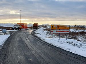
A plan to build protective barriers was made long before the recent earthquakes. This plan was put on hold because there was no immediate threat of an eruption. Also, there were worries about how it would affect the environment. However, on November 10, trucks started bringing materials to the site. This was near the Blue Lagoon and Svartsengi Power Station. This first operation was stopped due to worries about a possible eruption that day.
Construction officially started again on November 13. This was after the Althing (Iceland's parliament) approved a bill. Workers began building barriers. The civil defense department also prepared to extend these barriers to Grindavík if needed.
The Icelandic government added a small extra property tax. This tax will help pay for building lava barriers on the Reykjanes peninsula. It will protect local buildings from volcanic eruptions. This temporary tax will last for three years, starting January 1, 2024. It is expected to raise about 1 billion ISK each year.
After the Eruption
After the volcanic eruption on December 18, the Icelandic Coast Guard sent a helicopter to watch the activity. There were many delays at Keflavík International Airport, but it stayed open. The Blue Lagoon spa, which had just reopened, did not take bookings on the night of the eruption. Police raised alert levels. Civil defense authorities warned people to stay away from the area. Emergency workers were assessing the situation.
More to Explore
- Geology of Reykjanes Peninsula
- List of earthquakes in 2023
- List of earthquakes in Iceland
 In Spanish: Terremotos de Islandia de 2023 para niños


