
Aberdeen, Ohio facts for kids
Quick facts for kids
Aberdeen, Ohio
|
|
|---|---|
|
Village
|
|

Looking east on U.S. Route 52 in Aberdeen
|
|

Location of Aberdeen, Ohio
|
|

Location of Aberdeen in Brown County
|
|
| Country | United States |
| State | Ohio |
| County | Brown |
| Township | Huntington |
| Founded | 1795 |
| Platted | 1816 |
| Incorporated | July 5, 1816 |
| Area | |
| • Total | 1.63 sq mi (4.23 km2) |
| • Land | 1.35 sq mi (3.50 km2) |
| • Water | 0.28 sq mi (0.74 km2) |
| Elevation | 535 ft (163 m) |
| Population
(2020)
|
|
| • Total | 1,515 |
| • Estimate
(2023)
|
1,523 |
| • Density | 1,122.22/sq mi (433.21/km2) |
| Time zone | UTC-5 (Eastern (EST)) |
| • Summer (DST) | UTC-4 (EDT) |
| ZIP code |
45101
|
| Area codes | 937, 326 |
| FIPS code | 39-00142 |
| GNIS ID | 2397905 |
Aberdeen is a small village in Ohio, United States. It is located in Brown County, within Huntington Township. The village sits right along the Ohio River, about 50 miles southeast of Cincinnati. In 2020, the population of Aberdeen was 1,515 people.
Contents
History of Aberdeen
Aberdeen was first started by James Edwards in 1795. It was officially mapped out, or platted, by Nathan Ellis in 1816. This means they drew up plans for streets and building lots. The village became an official town on July 5, 1816.
Aberdeen was an important stop on Zane's Trace. This was an early road through the Northwest Territory, finished in 1797. Today, Aberdeen is connected to Maysville, Kentucky by two bridges. These are the Simon Kenton Memorial Bridge and the William H. Harsha Bridge. The Harsha Bridge is a modern cable-stayed bridge, completed in 2001.
Geography of Aberdeen
Aberdeen is located in a scenic area by the Ohio River. The United States Census Bureau says the village covers a total area of about 1.63 square miles (4.23 square kilometers). Most of this area, about 1.35 square miles (3.50 square kilometers), is land. The rest, about 0.28 square miles (0.74 square kilometers), is water, mainly from the Ohio River.
Population and People
| Historical population | |||
|---|---|---|---|
| Census | Pop. | %± | |
| 1820 | 87 | — | |
| 1830 | 165 | 89.7% | |
| 1840 | 405 | 145.5% | |
| 1850 | 808 | 99.5% | |
| 1860 | 836 | 3.5% | |
| 1870 | 871 | 4.2% | |
| 1880 | 885 | 1.6% | |
| 1890 | 874 | −1.2% | |
| 1900 | 711 | −18.6% | |
| 1910 | 568 | −20.1% | |
| 1920 | 477 | −16.0% | |
| 1930 | 452 | −5.2% | |
| 1940 | 497 | 10.0% | |
| 1950 | 551 | 10.9% | |
| 1960 | 774 | 40.5% | |
| 1970 | 1,165 | 50.5% | |
| 1980 | 1,566 | 34.4% | |
| 1990 | 1,329 | −15.1% | |
| 2000 | 1,603 | 20.6% | |
| 2010 | 1,638 | 2.2% | |
| 2020 | 1,515 | −7.5% | |
| 2023 (est.) | 1,523 | −7.0% | |
| U.S. Decennial Census | |||
How Many People Live Here?
In 2010, there were 1,638 people living in Aberdeen. These people lived in 760 households, with 454 of them being families. The village had about 1,213 people per square mile.
Most people in Aberdeen are White, making up about 96.2% of the population. There are also smaller groups of African American (1.8%), Native American (0.1%), and Asian (0.2%) residents. About 0.9% of the population identified as Hispanic or Latino.
Households and Families
About 26.3% of households in Aberdeen had children under 18 living with them. Nearly 40% of households were married couples living together. Some households had a female head without a husband (14.5%) or a male head without a wife (5.9%). About 35% of all households were made up of people living alone.
The average household had about 2.16 people. The average family had about 2.75 people.
Age of Residents
The average age of people in Aberdeen in 2010 was 41.9 years old.
- About 21.1% of residents were under 18 years old.
- About 9.5% were between 18 and 24 years old.
- About 24.1% were between 25 and 44 years old.
- About 28.8% were between 45 and 64 years old.
- About 16.6% were 65 years old or older.
The village had slightly more females (53.4%) than males (46.6%).
Gallery
-
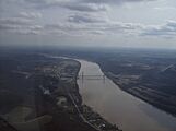
Along the Ohio River at Aberdeen
-
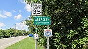
Aberdeen corporation limit sign


See also
 In Spanish: Aberdeen (Ohio) para niños
