Alaska Lake facts for kids
Quick facts for kids Alaska Lake |
|
|---|---|
 |
|
| Location | Kittitas County, Washington |
| Coordinates | 47°27′35″N 121°21′23″W / 47.45974°N 121.35649°W |
| Basin countries | United States |
| Surface elevation | 4,213 ft (1,284 m) |
| Islands | 0 |
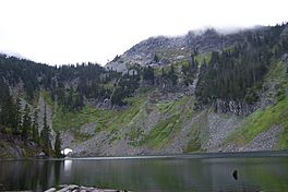
Alaska Lake is a beautiful freshwater lake. It sits on the western side of Alaska Mountain. This lake is right on the border between King County and Kittitas County, Washington. People love to visit Alaska Lake for hiking, swimming, and fishing. Nearby, you can find other mountain lakes. These include the Rampart Lakes, which are south of Alaska Lake. Hibox Mountain is also located to the east.
Getting to Alaska Lake
You can reach Alaska Lake by following the Gold Creek Trail #1314. This trail starts at Gold Creek Pond. Gold Creek Pond is on the north shore of Keechelus Lake. It is also south of Snoqualmie Pass.
The trail takes you through open meadows. These meadows have plants like slide alder and vine maple. You will then come to a waterfall. After that, you'll find Joe Lake. Most people who visit Alaska Lake come for a day trip. However, there are also campsites available. The Gold Creek Trail connects to the Pacific Crest Trail. This connection is found on the north ridge of Alaska Lake.
Weather Around the Lake
Alaska Lake is in a special climate zone. It's called a hemiboreal climate. This is part of the marine west coast climate. This type of weather is common in western North America.
The average temperature around the lake is 3° Celsius (37° Fahrenheit). August is the warmest month. The average temperature then is 16° Celsius (61° Fahrenheit). January is the coldest month. The average temperature drops to −6° Celsius (21° Fahrenheit).
The area gets a lot of rain. The average rainfall is 1687 millimeters (about 66 inches) per year. January is the wettest month. It gets about 396 millimeters (15.6 inches) of rain. July is the driest month. It only gets about 38 millimeters (1.5 inches) of rain.
|
||||||||||||||||||||||||||||||||||||||||||||||||||||||||||||||||||||||||||||||||||||||||||||||||


