
Alaska Mountain facts for kids
Quick facts for kids Alaska Mountain |
|
|---|---|

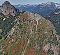
Alaska Mountain, southern aspect
|
|
| Highest point | |
| Elevation | 5,745 ft (1,751 m) |
| Prominence | 505 ft (154 m) |
| Geography | |

Alaska Mountain
Location in Washington (state)

Alaska Mountain
Location in the United States
|
|
| Parent range | Cascade Range |
| Topo map | USGS Chikamin Peak |
| Climbing | |
| Easiest route | Hiking |
Alaska Mountain is a 5,745-foot (1,751-meter) tall mountain in the Cascade Range. It's located in Kittitas County, Washington state. The mountain is part of the Alpine Lakes Wilderness area. This land is managed by the Wenatchee National Forest.
Alaska Mountain sits between Alaska Lake and Joe Lake. It's about 8 miles (13 km) northeast of Snoqualmie Pass. Mount Thomson is its closest and taller neighbor. The famous Pacific Crest Trail goes around its south, east, and north sides. You can also hike off the main trail to reach the top. Rain and melting snow from the east side flow into streams that join the Yakima River. Water from the west side goes into streams leading to the Snoqualmie River.
Contents
Weather at Alaska Mountain
Alaska Mountain is in a "marine west coast" climate zone. This means it gets a lot of influence from the Pacific Ocean. Most weather systems start over the Pacific. They then travel northeast towards the Cascade Mountains.
How Mountains Affect Weather
When these weather systems reach the Cascade Mountains, the air is forced to rise. As the air goes up, it cools down. This causes the moisture in the air to turn into rain or snow. This process is called orographic lift. Because of this, the west side of the Cascades gets a lot of rain and snow. This is especially true during the winter months.
Seasonal Weather Patterns
In winter, the weather is usually cloudy. But in summer, high-pressure systems over the Pacific Ocean become stronger. This often leads to clear skies with little or no clouds. Because of the ocean's influence, the snow here tends to be wet and heavy. This can create a high risk of avalanches.
How Alaska Mountain Was Formed
The Alpine Lakes Wilderness area has very rugged land. You can see jagged peaks, sharp ridges, and deep valleys carved by glaciers. There are also granite walls and over 700 mountain lakes.
Ancient Geological Events
Many millions of years ago, big geological events shaped this area. These events created the varied landscape and huge changes in elevation. These elevation changes also led to different climates and types of plants. The land here ranges from about 1,000 feet (300 meters) in lower areas to over 9,000 feet (2,700 meters) on Mount Stuart.
The Birth of the Cascades
The Cascade Range began forming millions of years ago. This was during the late Eocene Epoch. At that time, the North American Plate was slowly moving over the Pacific Plate. This movement caused many periods of volcanic activity. Also, small pieces of the Earth's crust, called terranes, helped create the North Cascades about 50 million years ago.
The Ice Age's Impact
During the Pleistocene period, which started over two million years ago, glaciers repeatedly covered and uncovered the land. As they moved, they scraped away rock and left behind debris. The last time glaciers retreated from the Alpine Lakes area was about 14,000 years ago. They had moved north of the Canada–US border by 10,000 years ago. The river valleys in this area have a "U" shape. This shape was created by these glaciers. The rising of the land (called uplift) and cracks in the Earth's crust (called faulting) worked with the glaciers. Together, these processes created the tall peaks and deep valleys we see in the Alpine Lakes Wilderness today.
Images for kids
-
Alaska Mountain from Alta Mountain

