Alatna, Alaska facts for kids
Quick facts for kids
Alatna, Alaska
Alaasuq
|
|
|---|---|
 |
|

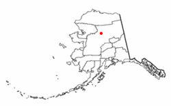
Location of Alatna, Alaska
|
|
| Country | United States |
| State | Alaska |
| Census Area | Yukon-Koyukuk |
| Area | |
| • Total | 36.48 sq mi (94.49 km2) |
| • Land | 36.48 sq mi (94.49 km2) |
| • Water | 0.00 sq mi (0.00 km2) |
| Population
(2020)
|
|
| • Total | 15 |
| • Density | 0.41/sq mi (0.16/km2) |
| Time zone | UTC-9 (Alaska (AKST)) |
| • Summer (DST) | UTC-8 (AKDT) |
| ZIP code |
99720
|
| Area code(s) | 907 |
| FIPS code | 02-01305 |
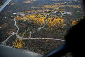
Alatna is a small community in Alaska, United States. Its name in the Iñupiaq language is Alaasuq. It is a special kind of place called a census-designated place (CDP). This means it's a community that the government counts for population, but it's not officially a city.
Alatna is located in the Yukon-Koyukuk Census Area. This area is part of the Unorganized Borough, which is a large part of Alaska without local government. In 2020, only 15 people lived in Alatna.
Contents
Where is Alatna Located?
Alatna is found in a very remote part of Alaska. It sits on the north bank of the Koyukuk River. This is southwest of where the Koyukuk River meets the Alatna River.
Distance from Major Cities
The community is about 190 miles (306 km) northwest of Fairbanks. It is also about 57 miles (92 km) upriver from Hughes. Alatna is just west of the city of Allakaket.
Alatna's Climate and Weather
Alatna has a very cold climate. Temperatures can be extremely different between summer and winter. In July, the average high temperature is around 70°F (21°C). But in January, the average low temperature is much colder than 0°F (-18°C). It's common for temperatures to drop to -40°F/C for long periods.
The hottest temperature ever recorded was 94°F (34°C). The coldest was a freezing -75°F (-59°C). Alatna gets about 13 inches (33 cm) of rain or snow each year. The average snowfall is about 72 inches (183 cm). The Koyukuk River is usually free of ice from June to October.
| Climate data for Alatna | |||||||||||||
|---|---|---|---|---|---|---|---|---|---|---|---|---|---|
| Month | Jan | Feb | Mar | Apr | May | Jun | Jul | Aug | Sep | Oct | Nov | Dec | Year |
| Mean daily maximum °F (°C) | −9 (−23) |
0 (−18) |
14 (−10) |
32 (0) |
51 (11) |
68 (20) |
69 (21) |
64 (18) |
50 (10) |
30 (−1) |
5 (−15) |
5 (−15) |
32 (0) |
| Mean daily minimum °F (°C) | −31 (−35) |
−25 (−32) |
−18 (−28) |
3 (−16) |
30 (−1) |
41 (5) |
44 (7) |
39 (4) |
30 (−1) |
12 (−11) |
−14 (−26) |
−27 (−33) |
7 (−14) |
| Average precipitation inches (mm) | 0.8 (20) |
0.7 (18) |
0.7 (18) |
0.4 (10) |
0.6 (15) |
1.3 (33) |
2.0 (51) |
2.2 (56) |
1.5 (38) |
1.2 (30) |
0.9 (23) |
0.8 (20) |
13.1 (330) |
| Source: Weatherbase | |||||||||||||
History and Culture of Alatna
Many Alaska Native groups have lived in the Alatna area for a long time. These include the Koyukon Athabascans and groups like the Kobuk, Selawik, and Nunamiut from the north.
Early Life and Trading
The Koyukon people used to live in different camps throughout the year. They moved to follow wild animals and fish as the seasons changed. Over time, different groups started to live together in settlements. The old site of Alatna was an important place for trading between Athabascans and Inuit people.
Important Events in Alatna's History
- 1906: The first mission, St. John's-in-the-Wilderness Episcopal Mission, was built on the Koyukuk River.
- 1925: A post office opened in Alatna.
- 1938: The community's name changed to Allakaket. The name Alatna was then used for the smaller Eskimo community across the river.
- 1957: The first public school was built.
- 1964: A big flood, caused by ice jamming the river, covered most of the community.
- 1975: The communities of Allakaket and Alatna officially became one city.
- 1978: A clinic and an airport were built.
- 1979: A new school and community roads were built.
- 1994: Another major flood destroyed almost all the buildings and food supplies. Residents had to rebuild on higher ground. This new location for Alatna is now outside the city limits of Allakaket.
Who Lives in Alatna Today?
Today, Alatna is home to a federally recognized Alaskan village called the Alatna Village. Most of the people living here, about 97.1%, are Alaska Native or part Native. The Alatna population is mainly made up of descendants of Kobuk Eskimos. Athabascan people mostly live in the nearby community of Allakaket. People in Alatna often rely on traditional activities like hunting and fishing for food.
Population Changes in Alatna
The population of Alatna has changed over the years.
Old Alatna (1920-1994)
| Historical population | |||
|---|---|---|---|
| Census | Pop. | %± | |
| 1920 | 32 | — | |
| 1930 | 131 | 309.4% | |
| 1940 | 28 | −78.6% | |
| 1950 | 31 | 10.7% | |
| 1980 | 30 | — | |
| 1990 | 31 | 3.3% | |
| 2020 | 15 | — | |
| U.S. Decennial Census | |||
The original Alatna first appeared in the 1920 census. It was located across the river from Allakaket. In 1930, the population numbers for Alatna and Allakaket were counted together. Alatna was not listed in the 1960 or 1970 census. When Allakaket became a city in 1975, it included Alatna.
In 1980 and 1990, Alatna was recognized as an Alaskan Native Village Statistical Area (ANVSA) within Allakaket. After the big flood in 1994, people moved Alatna to higher ground. This new location was outside the city of Allakaket.
New Alatna (1994-Present)
| Historical population | |||
|---|---|---|---|
| Census | Pop. | %± | |
| 2000 | 35 | — | |
| 2010 | 37 | 5.7% | |
| U.S. Decennial Census | |||
After the 1994 flood, the "New" Alatna village was created. In 2000, it was officially recognized as a census-designated place (CDP). In 2000, there were 35 people living in Alatna. There were 12 households and 6 families.
Public Services in Alatna
Life in Alatna is different from many other places. Residents often carry water to their homes. They use outdoor toilets, sometimes called honeybuckets or outhouses.
Community Facilities
- None of the 12 homes in Alatna have indoor plumbing yet.
- However, new improvements are being made. A new water source, a water treatment plant, and a sewage system have been built.
- There is also a shared electricity connection with Allakaket.
- Residents use the clinic, laundry facility (washeteria), landfill, and school in Allakaket.
- Electricity is provided by the Alaska Power and Telephone Company.
- There are no state-run schools directly in Alatna.
- The Alatna Clinic is a primary health care facility.
Economy and Transportation
The way people make a living in Alatna depends on the seasons. They mostly rely on "subsistence" activities. This means they get most of their food directly from nature.
How People Make a Living
- People hunt for salmon, whitefish, moose, and bear. They also gather small game and berries. Caribou are hunted when they are available.
- Some people earn money from trapping animals or making traditional Native handicrafts.
- During the summer, some residents find jobs in construction or helping with emergency firefighting for the Bureau of Land Management (BLM).
Getting Around Alatna
- Alatna does not have any roads connecting it to other towns.
- In winter, people use trails to travel to places like Hughes, Bettles, and Tanana.
- During the summer, river transportation is very important.
- There is a state-owned airport runway in Allakaket that is 3,500 feet long and has lights. It can be used all year.
- Because the water is shallow, large barges cannot deliver goods to Alatna by river.
See also
 In Spanish: Alatna (Alaska) para niños
 | Madam C. J. Walker |
 | Janet Emerson Bashen |
 | Annie Turnbo Malone |
 | Maggie L. Walker |

