
Albula/Alvra facts for kids
Quick facts for kids
Albula/Alvra
|
||
|---|---|---|

Mon village from the air
|
||
|
||

Albula/Alvra
Location in Switzerland

Albula/Alvra
Location in Canton of Graubünden
|
||
| Country | Switzerland | |
| Canton | Graubünden | |
| District | Albula | |
| Area | ||
| • Total | 93.93 km2 (36.27 sq mi) | |
| Elevation | 1,231 m (4,039 ft) | |
| Population
(Dec 2020 )
|
||
| • Total | 1,295 | |
| • Density | 13.787/km2 (35.708/sq mi) | |
| Postal code |
7084,7450,51,58,59,72,92
|
|
| Surrounded by | Riom-Parsonz, Salouf | |

Albula/Alvra is a town, also called a municipality, located in the Albula Region in the canton of Graubünden in Switzerland. A canton is like a state or province. On January 1, 2015, several smaller towns joined together to create the new municipality of Albula/Alvra. These towns were Alvaschein, Mon, Stierva, Tiefencastel, Alvaneu, Brienz/Brinzauls, and Surava.
Contents
History of Albula/Alvra
Alvaschein
The town of Alvaschein was first mentioned in records around 1154. This was when a nunnery (a place where nuns live) called Alvasinis was being built. Later, in 1282, it came under the rule of the Princes-Bishop of Chur. In 1367, it became part of a group of communities called Gotteshausband. The people of Alvaschein finally gained their freedom from the Princes-Bishop in 1732. Sadly, a big fire in 1745 destroyed almost the entire town. Since 1851, Alvaschein has been the main town for its local area.
Mon
Mon was first mentioned in old writings between 1001 and 1200 as de Maune. In 1281, it was called Mans. The town was known as Mons until 1943.
Stierva
Stierva first appeared in records in 841 as Seturiuo. Like Mon, its name changed over time, and it was known as Stürvis until 1943.
Tiefencastel
Tiefencastel was first mentioned in 831 as in Castello Impitinis. From the 14th century onwards, it became known as Tüffenkasten.
Alvaneu
Alvaneu was first mentioned in 1244 as Aluenude. In 1530, it was called Allweneü. In 2007, a media expert from Zurich was given the special, honorary title of "Prince of Belfort" by the town for one year. His job was to help bring more tourists and improve the local economy.
Brienz/Brinzauls
Brienz/Brinzauls was first mentioned around 840 as Brienzola. By the 12th century, it was an important trading place for the Bishop of Chur. The Lords of Brienz, who owned a strong tower in the village, were first mentioned in 1259. This tower later fell apart and was removed in 1880. Until 1851, the village was part of a territory called Herrschaft of Belfort. Between 1869 and 1883, Brienz/Brinzauls and Surava were joined together as one town. In 1874, a fire caused a lot of damage to the village.
The village church was first mentioned in 840. In 1519, St. Calixtus became the special saint of this church. In 1526, it became its own church area, separate from the church in Lantsch/Lenz. Later, in 1725, Surava also got its own separate church area from Brienz/Brinzauls.
From 1870 to 1873, a road called the Landwasserstrasse was built. This road helped connect the village to other parts of the country. In the 1960s, the number of farmers in the area started to decrease, but farming is still important. In 1990, about 43% of all jobs in the town were in farming. In 1860, everyone in the town spoke the Romansh language. By 1990, only 58% of the people still spoke it.
In May 2023, all the people living in Brienz/Brinzauls had to leave their homes. Geologists (scientists who study rocks and the Earth) believed that a very large amount of rock from the mountain above the village might fall. The village had less than 100 residents at that time. A big rockfall did happen in June, but luckily, it stopped before reaching the village. The residents were allowed to return home in July, but officials said that they might need to leave again in the future if there's another risk.
Surava
Surava was first mentioned around 1580 as Surraguas.
Geography

Based on a 2009 study, the towns that now form Albula/Alvra cover an area of about 93.93 square kilometers (36.27 square miles).
- About 28.1% of this land is used for farming.
- About 46.3% is covered by forests.
- About 2.8% has buildings or roads.
- About 1.1% is made up of rivers or lakes.
- About 21.8% is unproductive land, meaning it's not used for farming or building.
Looking closer at the land:
- Less than 1% of the built-up area is for houses and buildings, while 1.3% is for roads and other transport.
- Most of the forested land (41.3%) is dense forest, and a small part (2.1%) has orchards or small groups of trees.
- For farming, 1.0% is used for growing crops, 8.6% is for pastures (where animals graze), and 18.5% is for alpine pastures (high mountain grazing areas).
- Of the water in the town, 0.2% is in lakes and 0.8% is in rivers and streams.
- In the unproductive areas, 6.4% is unproductive plants, and 15.4% is too rocky for plants to grow.
Demographics
The total population of Albula/Alvra is 1,347 people (as of 2013).
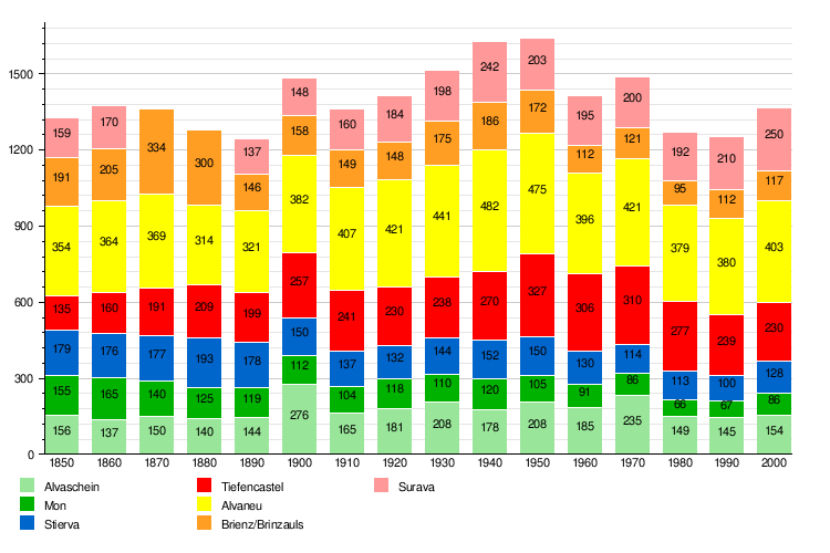
Historic population
The chart below shows how the population of the different towns that make up Albula/Alvra has changed over time:
Climate
Tiefencastel gets rain or snow on about 98.6 days each year. On average, it receives about 784 millimeters (30.9 inches) of precipitation (rain, snow, etc.). The wettest month is August, when Tiefencastel gets about 110 millimeters (4.3 inches) of precipitation over 10.8 days. June has the most days with precipitation, averaging 11.3 days, but with less rain, about 92 millimeters (3.6 inches). The driest month is February, with only about 35 millimeters (1.4 inches) of precipitation over 10.8 days.
Special Heritage Sites
Some parts of Albula/Alvra are very special! The Rhaetian Railway in the Albula / Bernina Landscapes is a UNESCO World Heritage Site. This means it's a place recognized globally for its unique cultural or natural importance.
Several churches in the area are listed as important Swiss heritage sites of national significance. These include:
- The Carolingian-era church of St. Peter Mistail in Alvaschein.
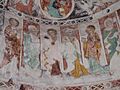
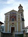
- The Baroque Church of St. Franziskus/S. Francestg in Mon.
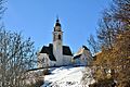
- The parish church of St. Stefan/S. Stefan in Tiefencastel.
The village of Alvaschein itself is also part of the Inventory of Swiss Heritage Sites.
The Church of St. Franziskus/S. Francestg was built by Capuchin monks between 1643 and 1648. It has beautiful frescoes (wall paintings) that were finished by Johann Rudolf Sturn. In 1915, some of these paintings were covered up, but after a restoration in 1975, the original frescoes can be seen again!
The church of St. Stefan/S. Stefan was first mentioned in 1343. In 1650, the Capuchin monks rebuilt and made it bigger. During this time, it was decorated with amazing wood carvings and paintings.
-
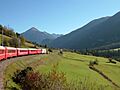
UNESCO World Heritage Site Rhaetian Railway in the Albula / Bernina Landscapes
-
Church of S. Peder E Conturn or St. Peter Mistail in Alvaschein
-
Church of St. Franziskus/S. Francestg in Mon
-
Parish church of St. Stefan/S. Stefan in Tiefencastel


See Also
